
-
 54791 Hits
-
 93.35% Score
-
 42 Votes
|
|
Mountain/Rock |
|---|---|
|
|
46.41480°N / 12.13560°E |
|
|
10393 ft / 3168 m |
|
|
Overview
geographical classification: Eastern Alps > Dolomites > Monte Pelmo
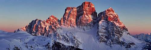
Monte Pelmo is one of the main peaks of the Dolomites mountains, although there are some higher ones.
The Dolomites are subdivided into massifs of limestone rock that are separated from each other by mountain passes, mostly with a good road. Monte Pelmo is a such a massif for its own. So it is also a mountain group such as Civetta Group, Pale di San Martino Group etc. More about the group at the end of the page.
As the mountain stands so alone as a giant block, it can be seen very well from other summits of the Dolomites - and of course it offers a great panorama for those who climb it. Monte Pelmo was the very first high mountain of the Dolomites that was climbed - on September 19th 1857 by the Englishman John Ball who later became the first president of the famous British alpine club - the very first alpine club. With his climb the alpine history of the Dolomites startet. You can still follow his footprints on the normal route, that has not become a via ferrata and requires experience and a good head for heights although no big climbing is demanded.
West of Monte Pelmo summit and separated by a deeply cutted pass (Fisura, 2726 m) is Pelmetto ("little Pelmo", 2990 m). This huge block with a 1100 m high north face is little only in comparison to near Monte Pelmo itself.
From the summit of Mounte Pelmo two ridges spread out and build two shoulders - Spalla Sud (3061 m) and Spalla Est (3024 m). Between them to the south is a huge "amphitheatre" - filled with many rubblestones. To reach this area is the key of the normal route on a passage called "Ball ledge".
If you don't want to climb but only admire this impressive mountain it is great to do the walk around Monte Pelmo, which takes one day with starting point at Forcella Staulanza. This is one of the nicest hikes in the Dolomites.
Difficult rock climbing seems not to be very popular at Monte Pelmo though many routes have been found in the past (see below). The most classic route on Pelmo and the only one Pelmo is famous for in climbing environments is "Rossi-Simon" (TD+), with 850 m drop. More difficult and more famous routes can be found near in Civetta group.
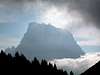
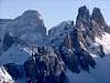
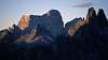
more pictures
many more nice pictures of this beautiful mountain have been posted:
 |
 |
 |
 |
 |
Getting There
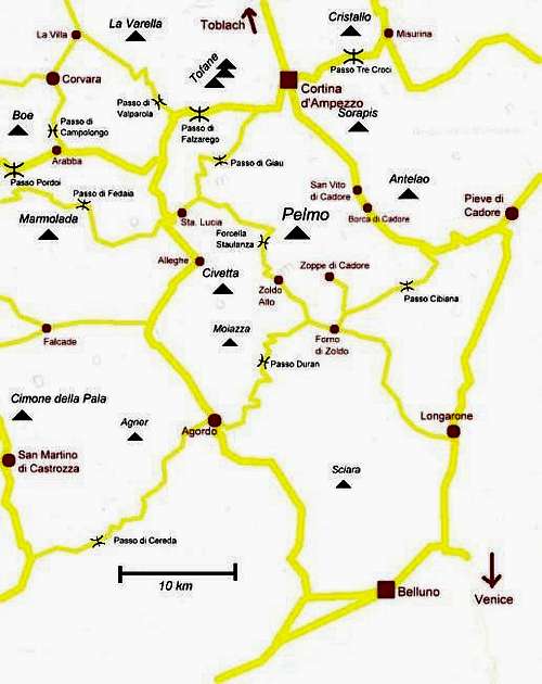
roads sketch
Monte Pelmo is situated between the well-known valley of Ampezzo / Cadore and the not so well-known of Zoldo. These two valleys are linked by the road over the Forcella Cibiana (1530 m) [mountain pass road]. Best starting point is the Passo Staulanza mountain pass (1765 m) west of the mountain.
Hut / Camping
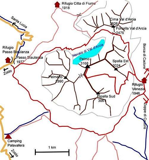
selmade outline
Basecamp for the climb is the mountain hut Rifugio Venezia (1946 m) (another name: Rifugio Alba Maria de Luca) east of the mountain where it is most convenient to stay the night. Two popular hiking routes through the Dolomites (Nr. 1 and Nr. 3) pass the hut, so you should make a reservation
You get there using marked mountain paths in:
· 2 h from the village Zoppe di Cadore
· 2 h 30 min from Passo Staulanza mountain pass - nice walk with great views to Monte Civetta, but often the path is very muddy
· 3 h 30 min from the village Borca di Cadore
· 4 h from Passo Staulanza via Forcella Val d'Arcia (2476 m). Nice walk directly underneath the north face of Monte Pelmo, but a little strenious because of many rubblestones. I recommend this with the shorter way back to Forcella Staulanza, so you have done the walk around the mountain in addition to the climb.
A campground in the upper Zoldo valley is Camping Palafavera (1516 m). You can start you climb directly from there.
routes overview
Normal routes
1. Normal route, Ball ledge; J. Ball 1857; II; 1200 m; 5 h;
2. Grohmann ledge; Grohmann / Lacedelli / Zuliani 1863; II-; 1200 m; 6 h; Variation of the normal route, reaches the amphitheatre by crossing Spalla Sud
3. Cesaletti ledge; Cesaletti /Giacin 1870; II; 1200 m; 6 h; Variation of the normal route, reaches the amphitheatre by crossing Spalla Est
To Spalla Est
4. S dihedral; Menegus/Bonafede 1964; VI A3; 400 m; ?;
5. S edge; Bianchi / Dal Pozzo 1948; V+ A1; 850 m; 10 h;
6. SE pillar; Bellodis / Franceschi 1955; VI; 800 m; 12 h;
7. E edge; Angelini / Vienna 1931; IV; 850 m; 7 h;
8. NE face "Via del Vecio"; Sommavilla / Angelini 1963; IV; 650 m; 5,5 h;
To north summit (between Pelmo main summit and Spalla Est)
9. NE face; Angelini 1932; III; 650 m; 3,5 h;
10. Eastern N face; Phillimore / Raynor / Dimai / Dibona / Colli 1897; IV; 550 m; 5 h; Bad rocks, not common
11. N Spur; Bovolenta / Sommavilla / Mosena / Rizzardini 1972; VI-; 650 m; 8 h;
To the main summit
12. N pillar "Pilastro Fiume"; Haag / Kroh / Schwarzwälder / Steiger 1968; VI; 850 m; ?; First climbers needed 3 days, upper 1/3 is route 13
13. NNW face ; Rossi / Simon 1924; VI-; 870 m; 12 h; The most classical difficult route at Monte Pelmo, some variations exist
14. WNW face "Via dei Bellunesi"; Garna /Gianeselli / Sommavilla Ducappa / Dal Mas 1971; V+ A1; 600 m; 12 h;
15. W edge; Brunhuber / Coletti 1933; VI; 430 m; 3,5 h;
16. W face; Sommavilla / Rizzardini 1970; III+; 350 m from Fisura; 3 h;
To Spalla Sud
17. SW face; Miotti / Bee / Groaz 1977; VI A3; 650 m; ? (3 days for the first climbers)
18. SW edge; Da Damos / Sommavilla / Pianon 1963; VI A2; 850 m;
19. S flank; V./G. Angelini 1925; III+; 950 m; 6 h;
to Pelmetto
20. Normal ; Spada / Panciera / Callegari 1895; III-; 1000 m; 5,5 h;
21. SE edge; Pohoryles 1935; VI-; 770 m; 7 h; Ends at normal route
22. SW pillar; Masucci / Pianon 1965; V+ A1; 900; 11 h;
23. WSW face; Grohmann / Leiß / Möhling / v.Siemens 1925; V+; 800 m; 6,5 h;
24. W face; Piva / Angelini 1948; IV; 780 m; 7 h;
25. S face, W face; B./E. Catiglioni 1923; III; 1000 m; 6 h;
26. Left W face; Gianeselli / Sommavilla / de Marchi / Dorotei / Sovilla 1933; V; 850 m; 8 h;
27. NW edge; Casara / Visintin 1936; IV+; 900 m; 10 h;
28. N face "Via dei Veneziani"; Masucci / Miconni 1962; V+; 1000 m; 17 h; Very wet
29. N edge; Reiner / Wairinger 1921; V+; 900 m; 10 h;
summit views
summit pano at www.alpen-panoramen.de
still no SP member has climbed Monte Pelmo on a day with a fine panorama view. If you can fill this gap - go ahead and post pictures!
 |
 |
Red Tape
no limits known to me
When To Climb
July to September is the normal season. The Ball ledge should be free of snow.
Maps / Books
Best map is Tabacco map 1:25000 Nr. 025 "Dolomiti di Zoldo, Cadorine e Agordine", available in almost every shop in the area.
A good hiking map for the center of the Dolomites is 'Freytag & Berndt 1:50.000 Nr. WKS 5 "Cortina d'Ampezzo - Marmolada"
A little map can also be found here on "www.planetmountain.com"
guidebook in german:
Dolomiten – Pelmo (with Bosconero, Moiazza, Tamer - Cime di San Sebastian) by Richard Goedeke, Bergverlag Rother München, 1st edition 1981 (still no newer one, but still available), ISBN 3-7633-1306-0
Monte Pelmo GROUP
As said in the overview, Monte Pelmo mountain group consists mainly of Monte Pelmo itself.
Boundaries of the group are:
- Passo Staulanza (mountain road)
- the Zoldo valley
- Forcella Cibiana (mountain road)
- the Cadore valley until San Vito di Cadore
- Forcella Forada (1977 m) north of Monte Pelmo
The only village inside the group is Zoppe di Cadore (1460 m), SE of Monte Pelmo
The whole area between Monte Pelmo and Passo Cibiana hardly reaches an altitude of 2000 m. So main parts here are forests.
As mountains can be called:
- Monte Penna (2195 m): a short hike from Rifugio Venezia at Monte Pelmo
- Monte Punta (1952 m): in the branch between Zoppe di Cadore and the Zoldo valley. A nice easy hike to the most central viewpoint of the Zoldo area
- Monte Rite (2182 m) - directly above Passo Cibiana, also a perfect viewpoint. In the first world war Italian troups built a road to and a fort on the summit.
 |
 |
Messner Mountain Museum
In 2002 famous mountain climber Rheinhold Messner opened a museum on Monte Rite. Because of it's height this "museum in the clouds" is open only in summertime from June until the first snowfall in fall. Access to the museum is possible in a 90 min walk from Passo Cibiana or with a bus shuttle service from there.
Homepage (unfortunately only in italian language): www.monterite.it
External Links
none at present