
|
|
Mountain/Rock |
|---|---|
|
|
38.08310°N / 119.3574°W |
|
|
12323 ft / 3756 m |
|
|
Overview
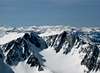
Twin Peaks is a mysterious mountain that guards the uppermost reaches of Virginia Canyon in Yosemite National Park. Unlike most mountains along the crest in the immediate vicinity, Twin Peaks is difficult to identify from the east along US 395, and many people frequently misidentify other peaks as "Twin Peaks".
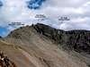
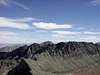
As the name implies, Twin Peaks has two summits, although they are hardly twins. The west summit is the high point at 12,323', which makes it slightly higher than its more famous neighbor, Matterhorn Peak (12,279'). The north side of Twin Peaks falls away in a series of cliffs and couloirs to the head of Horse Creek Canyon, which drains down in the R.V. hellhole known as Mono Village (at Twin Lakes). The south side of Twin Peaks is a jumble of nifty looking pinnacles and tedious talus slopes that drop down to Virginia Canyon. The south ridge connects to Virginia Peak. The saddle in between the two is known as "Twin Peaks Pass", which is easily reached from Virginia Canyon or from Spiller Creek. The south ridge offers a mostly class 2 route to the summit (with some class 3 scrambling around the prominent pinnacles high on the ridge). The west face offers a few challenging (and loose) looking chutes above upper Spiller Creek. The southeast side of the mountain (directly above Virginia Canyon) provides a class 2 gully (in between the "twin peaks") that extends all the way up to the broad summit plateau.
 |  |  |  |  |
Getting There
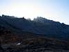
The north face of the mountain is approached via Horse Creek Canyon, which shares the same approach as Matterhorn Peak. Consult that page for a detailed description of the use trail up Horse Creek from Twin Lakes. The west face can be approached via Horse Creek Pass at the head of Horse Creek Canyon. The west face lies directly above the pass, opposite the SE slope of Matterhorn Peak. The south ridge starts at Twin Peaks Pass, which can be accessed either from the north via Horse Creek Pass and Spiller Creek, or from the east via Green Creek and Virginia Pass. The SE gully is most easily accessed via Green Creek and Virginia Pass. Of course any of these south and west side routes can also be accessed by a very long approach up Virginia and/or Spiller Canyons from Tuloumne Meadows.
 |  |  |  |
Red Tape
Twin Peaks straddles the Hoover Wilderness and Yosemite NP. Permits are required for overnight camping in these areas. Hoover permits may be picked up at the Toyaibe NF station on US 395 in Bridgeport. Yosemite permits can be obtained at Tuloumne Meadows station. No permits are required to dayhike.
When To Climb
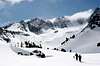
Anytime of year is a good time to climb. Summer is the most popular time, but Twin Peaks has also been skied in winter (usually as part of a Tioga to Twin Lakes ski tour). The fall is quite beautiful in this area, with no bugs, nice cool temperatures and easily obtained wilderness permits.
 |