
|
|
Mountain/Rock |
|---|---|
|
|
49.18722°N / 20.06000°E |
|
|
Mountaineering, Trad Climbing, Big Wall, Mixed, Scrambling |
|
|
7999 ft / 2438 m |
|
|
Overview
|
||
|
||
|
||
|
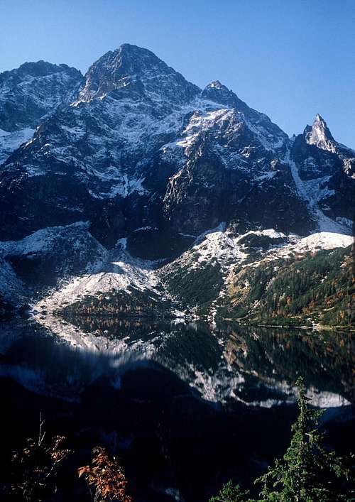
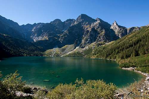
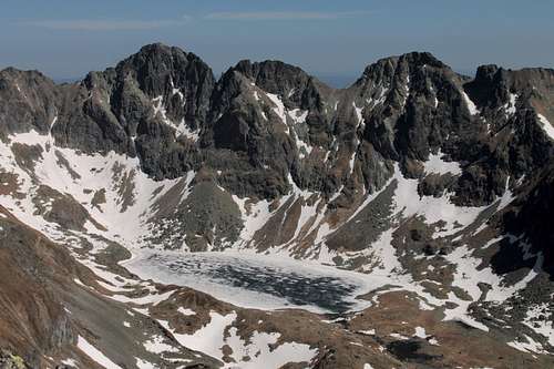
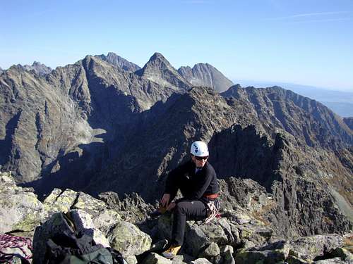
Mięgusz/Mengusák stands
|
||
|
Technical Climbing
|
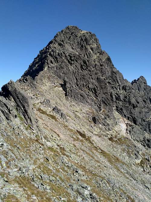
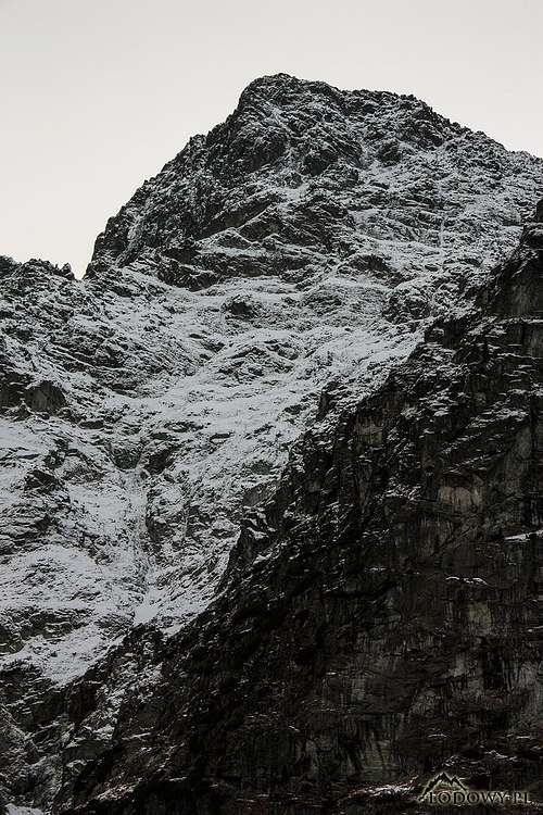
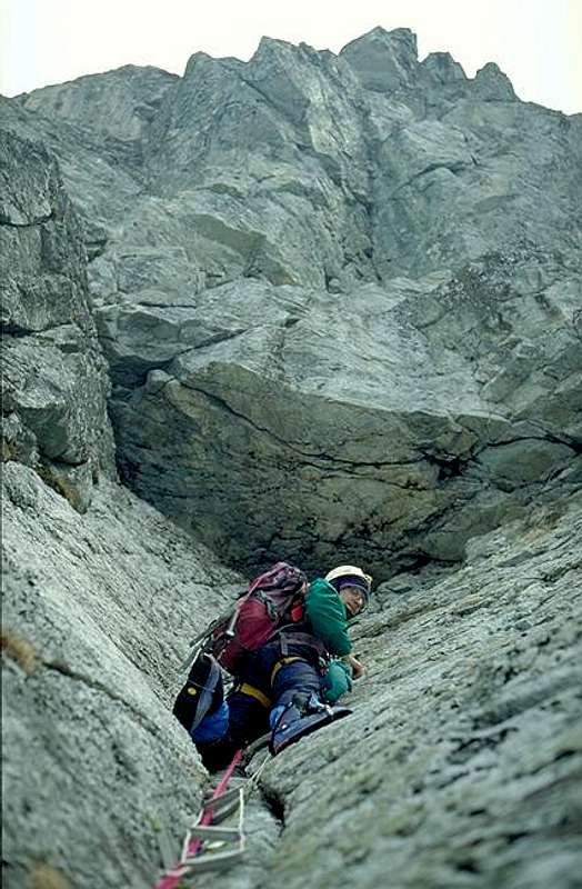
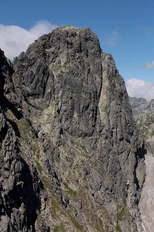
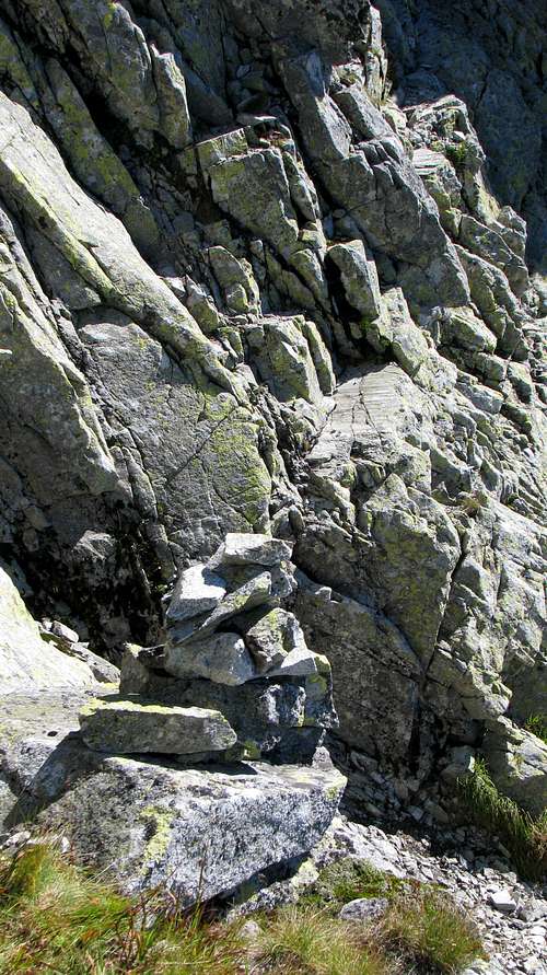
The north face of MSW, 880m tall, is the largest wall in Poland and the third largest wall in all of the Tatras. It is crumbly and grassy in many places, mainly climbed in winter and easily accessible from the south bank of Morskie Oko (approx.1hr from the hut). Here is the topo on www.taternik.net. Unlike the north face, the east face, whose height is 400m, is usually climbed in summer. There was a major rockfall here in 2009. Another one occurred in October 2021 and it is still active, so one had better keep away from the wall. The most popular with rock climbers is the 230m tall wall, called 'Czołówka MSW', at the base of the northeast buttress. The wall is easily accessible from the south shore of Morskie Oko, features solid rock and boasts about 30 routes (including variants), of which none is less difficult than UIAA grade VI.
|
Scrambling Routes
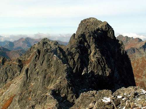
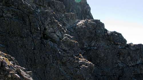
Remarks on rock difficulty ratingsAlthough the rock difficulty scale traditionally used in Polish guidebooks to the Tatras is said to be identical (at least towards the bottom of the scale) to the UIAA scale used in Slovakia, in practice it does differ from the latter in that it - or at least its bottom, which I have investigated - seems to be tougher, which means that a Polish grade 0+ ('easy') can actually be an equivalent of a UIAA grade I and a Polish grade I ('a bit difficult') will often be like a UIAA grade II. Differences between the ratings of a particular route can be from half to one and a half grade points. So, I have come to think that if you want to get a fairly 'safe' UIAA grade for a scrambling route in the Tatras, the following formula will work, most of the time: UIAA grade = Polish grade + 1From N (Poland)Route 1 The most interesting of the three routes: via waymarked trails to Dolina za Mnichem, then Via Galerie Cubryńskie to Hińczowa/Hincovo Pass. From the pass you can follow the ridge to the very summit, but this will entail a short UIAA III (at least YDS 5.3) climb up the first crag on the way, i.e. Mięguszowiecka Turniczka/Mengusovská vežička 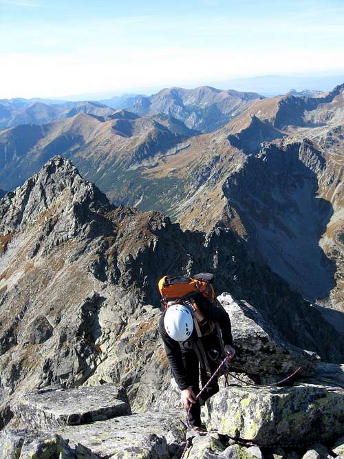 Ivona on W ridge Ivona on W ridgeor take the path which runs across the south, Slovak side of the ridge, almost horizontally towards the base of the step in the rib descending from the summit of the above-mentioned crag. Traverse the rib there (in August 2015 a rockfall barred the way, in August 2016 the passage was easy, further rockfalls there seem to be a matter of time though). When you have passed the rib, either a) go up directly to the crest, then follow it to the summit as the following picture illustrates  Route 1a by dynercia Route 1a by dynerciaor b) go diagonally up for about 20m until you get to a little cairn (next photo), then traverse two ribs – in the couloir dividing them you will see a chockstone several metres above you. Via the next, steep couloir (Polish grade 0+) move up for about 25m until you see a distinct horizontal ledge to your right. From that spot traverse the wall for about 70m, more or less horizontally via a system of ledges (Polish grade I), heading for Mięguszowiecki Balkon (first photo below). At that 'balcony' this route joins Route 2 ('Droga po głazach').
I have done variant b. Even though I had excellent descriptions of it (the guidebook by W. Cywiński - see References/Guidebooks) and the weather was perfect, I would say route finding was still a bit of a problem. Especially the very last couple of meters of the traverse turned out to be tricky to me. I stuck to the ledge that ran horizontally and at the crux I had to rely on a hold which was a bit loose. I guess I should have backed up several metres to try another solution, perhaps the path that ran just below mine, dipping a tad then going up a large slanting slab. Variant a – despite being more exposed and probably a little more technically difficult – is shorter, obvious and belaying, if needed, would be much easier.
Route 1 statistics Time up: 5hrs from Morskie Oko Hut Net elevation gain: 1043m Total elevation gain: approx. 1150m Rock difficulty: Polish grade I / my opinion UIAA II
Route 2 Via waymarked trails to Przełęcz pod Chłopkiem/Mengusovské sedlo, then Droga po głazach, where navigation can be surprisingly difficult and under unfavourable weather conditions becomes a nightmare. 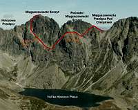 Route 2 by dynercia Route 2 by dynerciaRoute 2 statistics Time up: 5hrs from Morskie Oko Hut Net elevation gain: 1043m Total elevation gain: approx. 1200m Rock difficulty: Polish grade I / my opinion UIAA I-II  Routes 2 & 0 by Gorzi Routes 2 & 0 by GorziFrom S (Slovakia)Route 0 ('via normale') This is the easiest route to the summit: Via a waymarked trail to the south shore of Veľké Hincovo pleso, then along its east shore, later diagonally up across talus cones until you get to the top of the great talus cone that has formed below Mięguszowiecki Szczyt Pośredni/Prostredný Mengusovský štít. Still diagonally up a little across some grass, then about 150m up via a set of three chutes (this stretch of the route is far from obvious, especially on descent - you may put yourself in trouble if you have not done it upwards; the third, highest chute is unpleasantly crumbly) and rocky/grassy steps between them to the lower end of a major ramp called Veľká Mengusovská lávka/Wielka Mięguszowiecka Ławka. The rest of the route is part of "Droga po głazach' (see Route 2 above). 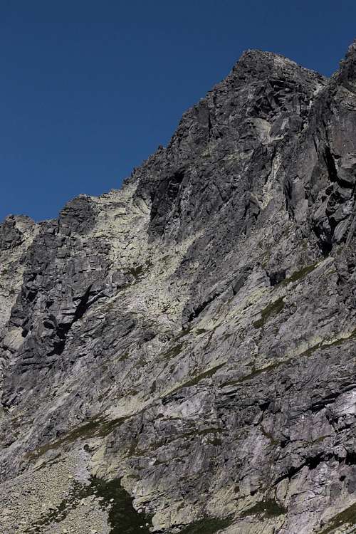 The talus cone and the light-coloured ramp above it - photo by Gorzi The talus cone and the light-coloured ramp above it - photo by GorziThe normal route is marked with yellow dots here on www.sprievodca.ta3.szm.com/ Route 0 statistics Time up: 3.5hrs from Popradské Pleso Hotel Net elevation gain: 944m Total elevation gain: nearly the same Rock difficulty: Polish grade I / Slovak sources UIAA I-II |
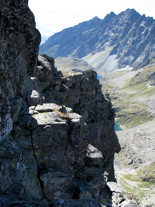
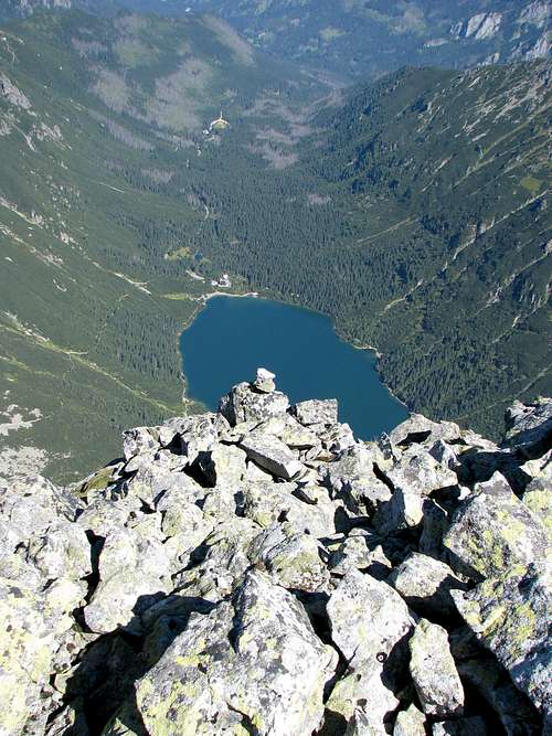
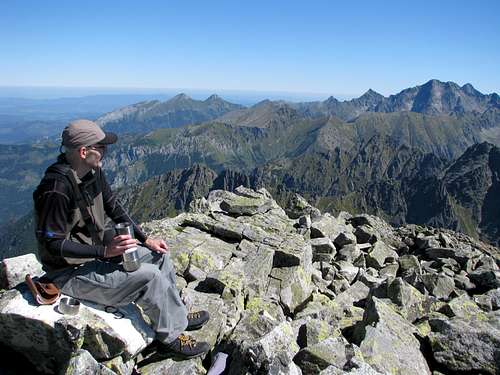
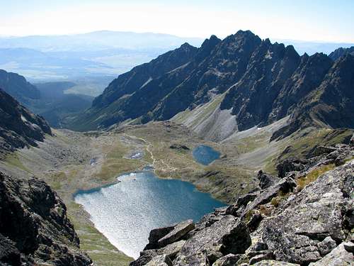
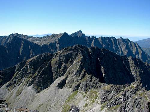
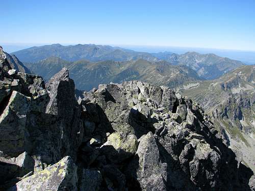
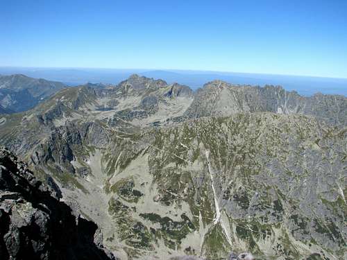
Summit Views
|

Getting There (to Nearest Hut)
|
Poland   Polana Palenica, where you will most likely be entering the national park, lies east of Zakopane, 12km away as the crow flies and nearly 25km away by road. Zakopane sits at the foot of the Tatra Mountains about 100km south of Kraków, where there's an international airport. (BTW The city of Kraków certainly boasts one of the most interesting old towns in East Central Europe.) It should take you less than two hours to drive from Kraków to Zakopane, but at the weekend or in high season, it often takes more than 3.5hrs, which is how long a journey by train lasts. As for the buses, check out this website. (The station adjoins the central railway station 'Kraków Główny'.) In Zakopane, minibuses to Polana Palenica (car park and bus/minibus terminus) leave from in front of the entrance to the railway station. Polana Palenica sits in the valley of River Białka, at about 985m. If you go by car, the only possible way to pay for parking is online. From Polana Palenica you walk up the valley along the same tarmac road (later with several shortcuts marked with red stripes) for about 1hr 45min (nearly 9km), making an ascent of 410m, until you get to the hut that sits by Morskie Oko. (About 25min before Morskie Oko is Polana Włosienica, where you can also get by horse-drawn wagon. A few hundred metres past the place is a restaurant with decent toilets next to it.) Slovakia   From a resort called Štrbské Pleso, built at the namesake lake (1346m), or the train (tram) stop Popradské Pleso (1245m) you will be walking north for about 1hr 15min (5 or 4km) along a waymarked trail until you get to the hut by a tarn called Popradské pleso, which sits at 1494m. The trail from Štrbské Pleso, marked with red stripes, is just a tad longer but it is very scenic.  |
Huts and Campsites
|
Poland
Slovakia
In high season expect all the huts (and the campsite) to be fully booked. You must book a bed online. In the good old days the huts normally offered a place on the floor but this isn't the case any longer. |


Maps
|
As for the analog maps, there are plenty of options. I would recommend the plastic 1:25,000 map of the Polish and Slovak Tatras by WiT. It has a large scale, is waterproof, durable and cheap. |
Red Tape
HikingPoland You must keep to waymarked trails. Bivouacking is not permitted. After dark you are supposed to leave the national park (unless you are staying in a mountain hut). Slovakia The same as in Poland plus that the trails above huts are closed for hikers from 1 November to 15 June. Rock ClimbingPoland You don not have to be a member of a rock climbing club. Just before your climb, you should write it into the register kept in a nearby mountain hut. (Make sure you sign it on return too!) During the approach you must stick to the traditionally used routes described in rock climbing guidebooks. Bivouacking on the wall is only allowed in an emergency. Slovakia You must be a member of a rock climbing club. Just before your climb, you should write it into the register kept in a nearby mountain hut/your hotel. (Make sure you sign it on return too!) During the approach you must stick to the traditionally used routes described in rock climbing guidebooks. Bivouacking on the wall is only allowed in an emergency. Except for winter, you must not do a route that is easier than UIAA grade III (approx. YDS grade 5.3) unless on the descent. The funny thing is that the last rule does not apply to those hiking/scrambling with a licensed guide whom they have paid some €200 for looking after them. 
|
Mountain Conditions & Rescue
|
The peak can be climbed all year round. As for scrambling, July to October, but it all depends on the weather. It is essential that you check the weather forecast. In high season as well as at weekends expect huge crowds on both the Polish and the Slovak approach trails described in the next chapter. 
|
References/Guidebooks/TRs
|
Unfortunately, none of the guidebooks listed below is available in English. J. Chmielowski and M. Świerz. Tatry Wysokie, przewodnik szczegółowy, vol. 1-4, Kraków 1925-26. W. Cywiński. Tatry przewodnik szczegółowy, vol.10 (Mięguszowieckie szczyty), Poronin 2003. W. H. Paryski. Tatry Wysokie, przewodnik taternicki, vol. 6, Warszawa 1954. Photo TR by R. Szadkowski, Tatra guide. TR by Michał - Projekty Przygodowe. 
|