

-
 36930 Hits
-
 80.97% Score
-
 14 Votes
|
|
Mountain/Rock |
|---|---|
|
|
47.41560°N / 121.5383°W |
|
|
5241 ft / 1597 m |
|
|
Overview

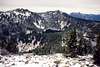
Bandera Mountain is another well travel classic in the I-90 corridor. Located between Mount Defiance and Granite Mountain this mountain receives a relatively heavy volume of traffic especially on it's western false summit.The larger eastern summit receives less traffic due to the fact that there is no trail to that summit and during summer the scramble is a Class 2 boulder scramble. In winter however is large snowbridge can form making head to the eastern summit a little easier.
 Bandera and Mason Lake
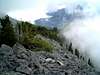
The route up to the false summit starts of very easy with the well grated Mason Lake Trail. This new trail goes past a beautiful waterfall and breaks out into the beautiful bear grass at about 4500 feet. There will be a spur trail (marked) that will go from there very steeply (but with good footing) up to the false summit of Bandera. Once on top of the false summit look for a boot path and then head down to the ridge up another false and then to the true summit of Bandera.

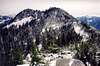
Views on both the false summit and the true summit on a clear day are very rewarding. Both provide greats shot of Rainier! The false summit gives good shots of Mason Lake and Defiance while the true summit gives a good closeup shot of Bandera and West Granite.
As for times to the top of Bandera it will take you roughly between 1 to 2 hours to the false summit and 30 minutes or more to the true summit. You will noticed the marked difference in the amount of people on the two summits.
 |  |  |  |  |
Getting There
VIA THE MASON LAKE TRAILHEAD: Take I-90 east from Seattle to exit 45. Cross north under the freeway and head west 3.8 miles to an obvious parking lot / trailhead (Mason Lake TH). |
Red Tape
Parking requires Northwest Forest Pass. Dogs are not recommended.When To Climb

This mountain can be climbed anytime. However in winter an ice axe and crampons are required for this trip. There is a cornice between the false and true summits that in winter can be dangerous, but in spring can actually offer a nice snowbridge to the true summit. Use caution and check conditions before attempting. Also in winter be aware of avalanche danger. The bear grass section is very steep leaving it prone to avalanches.
Camping
Follow regulations in Mount Baker-Snoqalmie National Forest.Mountain Conditions
Check with NOAA forecasts for western Cascades or Snoqalmie Pass. | 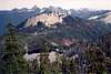 | 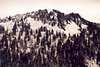 |  |
External Links
 alt="Click for Snoqualmie Pass, Washington Forecast" height=60 width=468>
- Washington Online Weather
Check for weather conditions here.
- Seattle P-I Description of Bandera Mountain hike.
wildstar - Nov 1, 2004 10:23 pm - Voted 10/10
Untitled CommentThe WSDOT web cam for I-90 can be found here.
wildstar - Jun 16, 2005 12:58 pm - Voted 10/10
Untitled CommentNOAA Weather

wildstar - Feb 19, 2007 10:46 pm - Voted 10/10
Road 9031 is closedAs of Feb 19, 2007 road 9031 is closed because it is washed out.