
|
|
Mountain/Rock |
|---|---|
|
|
47.76800°N / 15.80570°E |
|
|
Hiking, Trad Climbing, Sport Climbing, Via Ferrata, Skiing |
|
|
Spring, Summer, Fall, Winter |
|
|
6811 ft / 2076 m |
|
|
Overview
Schneeberg with the summit Klosterwappen is the highest mountain of Lower Austria (Niederösterreich) and the most eastward 2000m mountain of the alps. Nearly the whole region is a water protection area (1 st Vienna water supply)Near Fischerhütte is the summit Kaiserstein - named after emperors Franz I sucessful ascent in 1805 and 1807.Schneeberg is often underestimated (rapid weather changes - with snow, heavy rain, fog, strong winds) - orientation might be very difficult. This YouTube video shows some strong wind near Fischerhütte strong wind near Fischerhütte
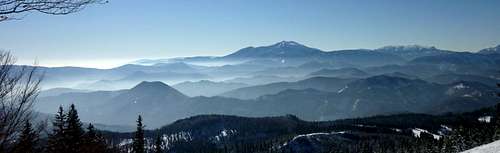 Schneeberg from Untersberg Schneeberg from Untersberg |
|---|
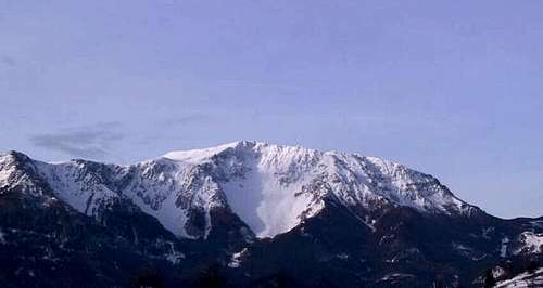 Schneeberg from Puchberg/Schneeberg Schneeberg from Puchberg/Schneeberg |
In summer (May to November) the rack railway (starting in Puchberg am Schneeberg) is the easiest ascent (about 1 hour walk to the summit).
 near Damböckhaus near Damböckhaus |
|---|
South side - Climbing
Very nice climbs in Höllental (near Reichenau an der Rax)
 Stadelwand Stadelwand |  Stadelwandgrat Stadelwandgrat |  Vordere Stadelwand Vordere Stadelwand |
|---|---|---|
 Grossofen Grossofen |
North Side - Skitouring
in spring time several nice steep ski descents.In winter ski touring starts usually at Losenheim (near Puchberg am Schneeberg).
 Fadensteig near Edelweisshütte Fadensteig near Edelweisshütte | 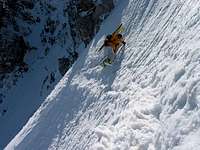 Fadensteig Fadensteig |  Fadensteig Fadensteig |
|---|---|---|
 Rote Schütt Flanke Rote Schütt Flanke |  Lahning Ries Lahning Ries |  Schneeberg Plateau Schneeberg Plateau |
Hiking
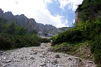 Schneidergraben Schneidergraben |
|---|
Getting There
North side: Puchberg am SchneebergSouth side: Reichenau an der Raxby car: Form Vienna on the highway (Südautobahn - A1) to Wiener Neustadt - continue via Ternitz to Puchberg am Schneebergor (for the south side of Schneeberg) from Ternitz (continue an Semmeringschnellstraße - S6) to Gloggnitz to Reichenau an der Raxby train: from Vienna (Südbahnhof) via Wiener Neustadt (you have to change the trains) to Puchberg or to Reichenau. Puchberg and Reichenau bus transfer to the mountains (sometimes!!!)
Rack Railway
The rack railway was built between 1985 and 1897. The line is 9.85 km long and climbs 1.218m to its final destination at 1,795m. The line has a rail gauge of 1.000 mm and uses the Abt rack systems. Opertion of the rack railway started in 1897 with coal-powered steam locomotives, which have been in use until 1999. The steam locomotives are still in use for nostalgia trains. In 1999 new diesel operated Multiple Units called Salamander, which meet strict environment protection regulations, have been introduced. After World War II until 1996 the rack railway was operated by the Austrian Federal Railways (ÖBB). Since 1997 the rack railway is operated by the Niederösterreichischen Schneebergbahn GmbH (Lower Austrian Schneeberg Railway Company Ltd.) - 50% held by the ÖBB and 50% held by the federal state of Lower Austria
 old steam locomotive old steam locomotive |  new diesel MU new diesel MU |
|---|
Red Tape
More or less the whole area is a water protection area (first Vienna Water Supply)Krummbachgraben (near Kaiserbrunn) strictly no trespassing!!
When To Climb - Winter + Spring
Ski Touring
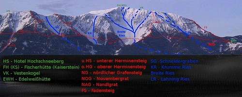
The steep descents on the north side in springwestward descents: Schneegraben: starts directly at Klosterwappen summitWurzengraben: starts at FischerhütteSalvisgraben: near Schauerstein to DreibrunnekesselHoyosgraben: starts near Vestenkogel to Dreibrunnenkessel Fadengraben: starts near P. 1723 (Fadensteig) In Hoyosgraben (also in Salvisgraben) is a cuesta/cliff (skiing around is usually possible)
 Wurzengraben (Feb. 2008) Wurzengraben (Feb. 2008) |  Ascent to Fischerhütte Ascent to Fischerhütte | 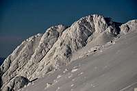 View from Schneegraben to Schauerstein View from Schneegraben to Schauerstein |
|---|
Info to "Breite Ries": descents from left to right:
 ski descents Schneeberg
Narrndattl Rinne, Privat Ries, Breite Ries, Vestenkogel Ostrinne, Rote Schütt Flanke
| Lahning Ries - April 2006 |  Breite Ries - June 2006 Breite Ries - June 2006 |
|---|
When To Climb - Summer
Climbs on the north side
- Herminensteig
- Novembergrat
- Gamsgartlgrat
- Bürklesteig
 Bürklesteig Bürklesteig |
|---|
Climbs located in Stadelwandgraben (south side)
(all information in German):
- Plattensymphonie - first climbed in Aug. 2007
- Des Kessels neue Kleider - route first climbed in Oct. 2006
- Neuer Zimmerweg first climb in Stadelwandgraben (first climbed 1906) - "reopened" (cleaned, straightened, bolts etc.) in Oct. 2005
- Bruderherz - a new route (first climbed in 2004) near Richterkante
- Richterkante - this climbing route (first climbed in 1929) has been cleaned, straightened in 2002 (also a lot of bolts now)
| Daham is Daham |  Richterweg Richterweg |  Durststrecke + Des Kessels neue Kleider Durststrecke + Des Kessels neue Kleider |
|---|
Huts (+ Camping)
no camp sites - camping is forbidden due to water protectionall huts except Edelweisshütte are closed in winter (on weekends a team of mountain rescue members are at Heinrich Krempel Hütte)
Edelweißhütte: 1235m (closed in November)Sparbacherhütte: 1248m has been sold and is no longer openboth huts near Losenheim (45 minutes walk)www.alpenverein.at - Edelweißhütte
 Edelweisshütte Edelweisshütte |
|---|
Kienthaler Hütte: 1380m usually, open from the beginning of May to end of October on the weekend2,5 - 3 hours from Losenheim, 2,5 hours from Weichtalhaus www.kienthaler.atHeinrich Krempel Hütte: 1561mhut of the Austrian Mountain Rescue (Bergrettung) - the hut is not open to the public (no sleeping facilities, no food - in winter ski tourist may get a hot tea)2 hours from LosenheimThe hut is named after Heinrich Krempel (1880 - 1935) - a cofounder of the Austrian Mountain Rescue Service.
 Krempelhütte (May) Krempelhütte (May) |  Krempelhütte (Mar) Krempelhütte (Mar) |
|---|
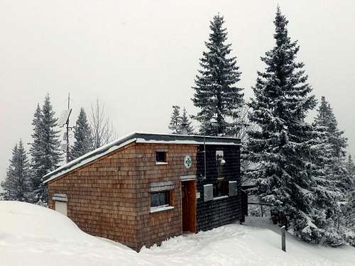 The rebuilt Krempelhütte
Weichtalhaus: 563m near Reichenau near the road starting point for climbs in the Höllentalwww.weichtalhaus.at
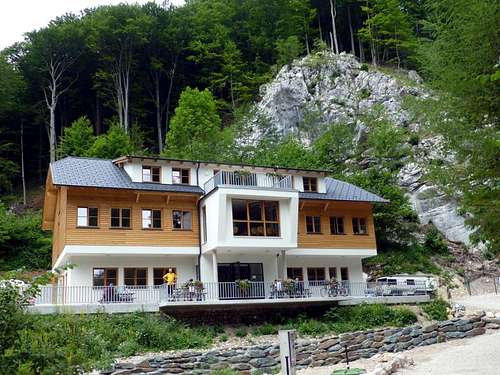 Weichtalhaus
Fischerhütte: 2049mnear the summit of Kaisersteinopen from beginning of May to end of October1 hour from the top station of the rack railway2,5 hours from Losenheim (on Fadensteig)3,5 hours from Losenheim (via Heinrich Krempel Hütte)Fischerhütte is named after Fischer von Röslerstamm, who wrote the first guidebook of Schneeberg.
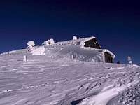 Fischerhütte Fischerhütte |  Fischerhütte Fischerhütte |
|---|
Damböckhaus: 1810m15 minutes from rack railway stationclosed in winter
 Damböckhaus Damböckhaus |
|---|
Naturfreundehaus Knofeleben (Friedrich Haller Haus): 1250 mclosed in Winter2 hours from Reichenau3 hours from Kaiserbrunn
Mountain Conditions
Usually the hut wardens give information
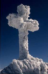 Klosterwappen - Summit Klosterwappen - Summit |  |
|---|
Links (Webcams) - Books etc.
Webcams
www.schneeberg.tvseveral Webcams - www.schneeberg.tv (from Fischerhütte, Damböckhaus etc.)www.bergsteigen.at have a look at the "Touren" section of www.bergsteigen.at - sorry only in German.
Maps
detailed map online: Austrian Map Online
Books
Skiführer Schneeberg the most comprehensive Alpine Touring Ski Guide Book (by Wolfgang Ladenbauer)