

|
|
Mountain/Rock |
|---|---|
|
|
40.52300°N / 118.171°W |
|
|
Pershing |
|
|
Hiking |
|
|
Spring, Summer, Fall, Winter |
|
|
9836 ft / 2998 m |
|
|
Overview
Star Peak is the highest peak in the Humboldt Range in Pershing County, north-central Nevada, about 30 minutes north of the town of Lovelock. From below, Star Peak looks to be an unremarkable peak, but looks can be deceiving: it is truly a hidden gem should you take the time to explore the range and hike the summit. It is a classic Great Basin Nevada mountain, with all the sage slopes and impressive vistas you could hope for.
Star Peak is one of just 57 peaks in the Lower-48 that exceed 5,000 feet of prominence, and "ultra" peak by that standard. It is also popular with range and county highpointers as well. A poor-quality dirt road works its way high into the range, almost near the range crest, allowing for an easy hiking route, although many people choose to approach this peak from any number of cross country routes.
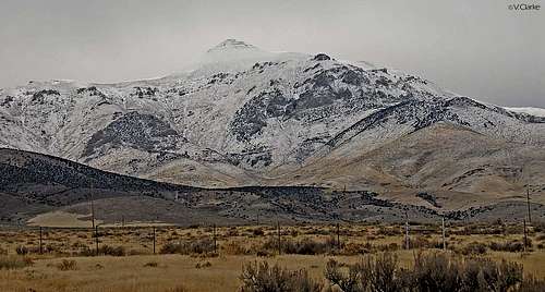 January 2012 picture taken by uziduzit
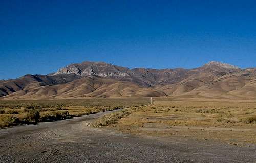 Star Peak is to the left (photo by Dean Molen)
Getting There
Exit Interstate-80 at the Humboldt Exit (#138, I believe), about 30 miles north of Lovelock (nearest full-service town) and about an hour south of Winnemucca. The interstate here runs essentially north-south. Get onto the east side of the exit and follow a frontage road south a few miles to where it ends. Proceed eastwards along a reasonable-quality dirt road into El Dorado Canyon.
Most passenger vehicles should be able to get to within the canyon near some abandoned buildings at approximately 5,700 feet elevation in dry conditions. The last mile or so has some boulders in the road. On my visit here in 2002, I found the route with no troubles but did note there were other roads criss-crossing herein, so pay attention and stay on the main route and you should be fine.
(Have the USGS "Rye Patch Reservoir South" and "Star Peak" maps handy to trace your route)
Depending on your vehicle, courage or lack of good judgment, you can continue up this road to almost 9,000 feet, from whence the summit is just a simple one-mile trek amid open sage slopes. However, most people start hiking from somewhere farther down. My Nissan Frontier 4wd truck got us up another 1,100 feet before I parked at a hairpin turn. Smaller jeeps can get higher. I do not believe the road is maintained. The upper-most sections are extremely rocky and exposed ... probably rate a 6 or 7 on the 4wd-road scale.
Black Canyon approach: Rob Woodall posted a great description/trip report of how he went up via the Black Canyon approach. He also posted a GPS track and a link to his photos so well worth checking out. See it HERE
The east side Star City route has been done by Dean Molen (see route to the left) and Gerry Pennington who posted his TR on peakbagger.com
Red Tape
None. This is BLM country. Enjoy. Winnemucca has a BLM office where up to date information might be obtained.
Google Winnemucca BLM district office for more information.
When To Climb
In dry conditions (Generally May - Oct) it is an easy, steep hike, nothing more. Since you hike a road and the slopes up high are generally gentle, this peak can potentially be hiked in snow conditions assuming you allow for the snow to settle a bit.
Camping
I did not see any developed camping nearby. There seems to be some active mining in the area. On the other hand, car-camping in out-of-the-way areas is possible. Lovelock is a small town but is the county seat of Pershing County. It has groceries, hotels, gas and restaurants.
Weather

Click for weather forecast
Click for weather forecast
Updated Trailhead Information (2005)
Petter Bjorstad's Star Peak report has an alternative route that appears to be viable, and includes some excellent links to photographs
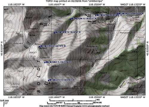 Dean's route from the NE. We followed the road shown coming from the W. (Image by Dean)
External Links
• Pershing County (NV) Highpoint Trip Report This is a description of my hike in 2002, with more photos.
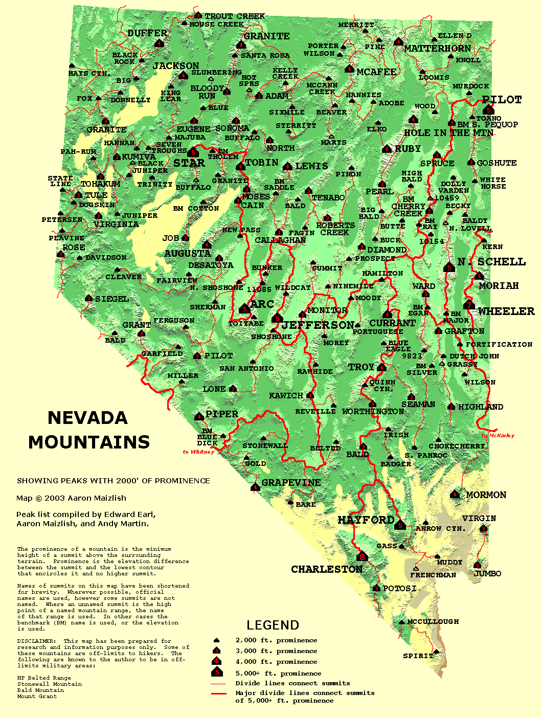
• The 57 Peaks with 5,000 feet of Prominence in the USA (Greg Slayden's www.peakbagger.com site)
• Locator Map of Nevada's many 2K Prominent Peaks A nifty and well-done map put together by Aaron Maizlish
Dean - Jan 28, 2006 11:29 am - Voted 10/10
Untitled CommentStar Peak is also one of the sought after prominence peaks in Nevada as it ranks #6 on the list. While it is not one of the highest peaks in Nevada, it stands out rather dramatically from valleys around it, giving it 5400 feet of prominence. This prominence puts it in an elite group of peaks in the USA that have a prominence of over 5000 feet and those can be seen on this neat MAP HERE. If you don't understand what prominence is all about, here is a good explanation. Adam Helman recently authored a book completely dedicated to prominence.
MoInfo - Nov 14, 2011 11:59 am - Hasn't voted
Getting there updatedThe parallel (to I-80) service rd going back south from Exit 138 has been extended (there is much mining in the area). Further there are several roads going east off of the service road - it's easy to get a little lost in you haven't been there before. You want to go precisely 4.5 miles south from the freeway exit and take the road that goes east from there. It veers off to the left as the service road itself is making a left hand jog.
Moogie737 - Oct 10, 2017 1:39 pm - Hasn't voted
Key point along the roadThe crazy "jeep" road leading up from the hard switchback at the old mining camp is quite drivable in 4WD low gear up to a point. Pick your point. We drove to 6,800' in a Toyota 4Runner and felt like we could have gone further but chose to park where it was easy to turn around. At about 7,700' there is a long more-or-less level stretch with several nice places to pull off. Upon reaching an elevation of approximately 9,000' there is a one-foot-high cairn on the right. At this point the "main" road continues north, but if you look back toward the SE you can see another jeep-type trail/road heading up a slope which steepens quickly. It isn't nearly as well-defined as the road you have been walking but it IS the correct way to go. After taking this road (it's a hard right switchback at the cairn) you will soon see an antenna ahead, but that is not the summit antenna. The summit antenna comes into view occasionally and it is south and slightly west of the lower antenna. For us, descriptions of leaving the road and heading straight up were a bit confusing, and to our knowledge, nobody had said anything about the cairn and the hard right switchback. We chose to proceed straight along the "main" road past the cairn and soon afterward the road went around a bend and petered out completely. So we had to head south over a bump and from there we could see both the lower and the summit antennae clearly. The boondoggle cost us about 30 minutes of time, but the experience taught us a little bit more about the things to look for heading up.