
|
|
Mountain/Rock |
|---|---|
|
|
42.13820°N / 74.1745°W |
|
|
3840 ft / 1170 m |
|
|
Overview
Plateau Mountain is located in the Catskill Park. in Greene County. Nearest towns are Hunter and Tannersville.
 Map of the route
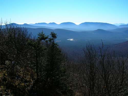
Plateau Mountain is the eastern mountain rising up from Stony Clove or Devil's Tombstone. The summit is at the eastern edge of the two-mile-long plateau. There is a view at the western edge of the plateau from a ledge that overlooks Stony Clove and Hunter Mountain, and another viewpoint to the east, just above Mink Hollow. The shortest access is from the east via Mink Hollow and the Devil's Path. However, the best view is at the western end of the summit ridge. Access from the west is from Devil's Tombstone via the Devil's Path.
Quad Info
USGS Quad 24k, Hunter, Quad # = o42074-b2
USGS Quad 100k, Pepacton Reservoir, Quad # = f42074-a1
USGS Quad 250k, Binghamton, Quad # c42074-a1
 |
Getting There
North Approach to Devils Tombstone.Exit I-87 at exit 20 (Saugerties) and turn left on route 32 then take the first right after crossing the NY Thruway. Follow route 32 for a total of 6.2 miles at which time you will want to stay left on route 32A at the “Y”. Follow this to Palenville for 1.9 miles at which time you will want to stay left on 23A at the “Y”. Follow route 23A for 9.2 miles while passing through Haines Falls and Tannersville to route 214 at the bottom of the hill. Follow route 214 up and over the Notch and down to the parking lot on the right at Devils Tombstone. (parking fee)
South Approach to Devils Tombstone.
Exit I-87 at exit 19 (Kingston) and turn right (traffic circle) on route 28, follow route 28 west for 22 miles. You will pass through the towns of West Hurley, Shokan, Boiceville and Mt. Tremper before reaching Phoenicia. Exit route 28 at Phoenicia for route 214. After weaving through town head northeast along the Stony Clove Creek for 10 miles to the parking lot on the left at Devils Tombstone. (parking fee)
Mink Hollow Via Tannersville.
At the only (as of 2002) traffic light in Tannersville head south or down hill on County route 16, after about 0.3 of a mile stay right at a “y” intersection, follow route 16 (Spruce Street) for 1 mile to a sharp turn to the left, stay left on route 16 for 0.4 of a mile to another “Y”, stay right on Elka Park Road for 0.4 of a mile to the Elka Post office, stay straight. Continue for another 0.5 miles to a left hand turn (Roaring kill road). Turn left and follow the Roaring kill for 0.3 of a mile. Turn right onto Mink Hollow road, follow this to its terminus at about 1.4 miles
 |
Red Tape
See the NYS Dep. of Environmental Conservation Web SiteRed Tape and info about Back Country Camping.
Camping
Camping at Devils Tombstone CampgroundClick on link for more information
Devils Tombstone.
Back Country Camping
Red Tape and info about Back Country Camping.
When to Climb
This Mountain peak or the portion of Devils Path (from route 214 to Mink Hollow) can be climbed all year around. Spring through summer is typically the busier time of the year. The west approach from Devil’s Tombstone will hold snow and ice, due to the shadowed exposure and steepness. I‘ve been on this mountain in all conditions, so with the appropriate gear for the elements it can very enjoyable.Crampons for either approach (Devils Tombstone-West, Mink Hollow-East) in the winter months and standard weather gear (in case of rain) in the other three seasons.
Misc.
Devils Path – Partial LoopI usually did this peak as a morning outing. I would have someone drop me off at the Devils Tombstone trailhead (route 214) and hike over to Mink Hollow and walk or hitch hike back to town.
Another option is a shuttle, Leave one car at either end of the Devils Path trail (Prediger Road or Route 214). This would entail about 13.75 miles of hiking with only about 4,550 of total elevation gain.
In the early eighties I worked on a development project that almost created hundreds of building lots and a possible ski resort in the bowl coming off the northern portion of Plateau Ridge line. It would have bordered state lands on the south and a portion of the east and west sides. The housing development would have reached all the way to the Schohaire Creek. So consequently I have walked almost every square foot of this mountain.
Mountain Biking
Rules of Mountain BikingRules of Mountain Bike
If looking for a place to stay and have a guided ride contact Mountain Bike Inn and ask for Ernie. Tell him Rik sent you, either you'll get a deal or a screwing. Regardless of the out come you'll have fun.
Weather
Weather in the CatskillsSpecial Thanks
Special thanks to grandwazoo for his original submission of this beautiful mountain.External Links
- The Catskill 3500 Club Peaks
Descriptions of all 35 of the Catskill Peaks that exceed 3,500 feet elevation.