
|
|
Mountain/Rock |
|---|---|
|
|
48.13000°N / 120.675°W |
|
|
8400 ft / 2560 m |
|
|
Overview
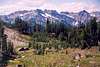
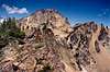
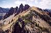
Pinnacle Mountain doesn't look like a pinnacle but there are plenty of spires and pinnacles on its flanks that apparently lend it its name. For sure Pinnacle is one of the highest summits in the region and the state in general (it is approximately 76/100 on the Washington Bulger Top 100 list). The mountain is located in the Chelan Mountains, which border the west side of Lake Chelan. Pinnacle is the north-end anchor of this chain but it sits a little farther away from the lake than peaks along the divide to the south--peaks such as Saska, Emerald, and Cardinal peaks. These three are less than five miles away to the southeast. Also nearby to the west are Spectacle Buttes and peaks of the Fernow Group.Pinnacle has two overall facades: a steep scree and talus west side and a precipitous (possibly even overhanging) east side. The upper East Face is really quite spectacular and probably remains unclimbed, which is too bad considering the rock is comprised of that stuff rock climbers love so much: granite. The north-south ridgeline of the peak jerks along for quite a distance all the way to the North Summit. Further, the summit area itself is laid out more like a fin than a pinnacle. As you scramble the relatively benign west side of the crest the last few paces to the summit, you realize just how close you are to an entirely different scene on the other (east) side. There are no glaciers surrounding Pinnacle but there is a decaying sheet of ice in the cirque on its east. The mountain's overall appearance is of a scrofulous patriarch of the Entiat. Nope, not even the pumice depositions from nearby Glacier Peak have scrubbed this bad boy clean.
 |  |  |  |  |
Getting There
There are three general trail approaches to the immediate vicinity of Pinnacle: 1) The Entiat River Trail to the Sheep Driveway Trail, 2) The Entiat River Trail to the Snow Brushy Creek Trail, and 3) the Emerald Park Trail to Milham Pass. Each of these will be treated below. Another cross-country approach that I will not elaborate on is via the Tumble Creek drainage on the peak's NNE. This route would start from Railroad Creek (from the trail between Lucerne and Holden that parallels the south side of Railroad Creek). One should expect brush low in the Tumble Creek valley, but open terrain farther up. This approach/deproach can be combined with the Emerald Park approach to make for a long loop trip.To get to the Entiat River Trail, exit Alt.US-97 just south of the town of Entiat on the west side of the Columbia River and take the Entiat River Road northwestward. Keep on the road (paved for most of the way) for 38 miles to its end just past Cottonwood Camp. Elevation = 3,140 ft.
To get to Lucerne for the Emerald Park route, it will be necessary to take The Lady of the Lake to Lucerne and start from there. This slow boat leaves from the south end of Lake Chelan once a day. Faster boats make two trips a day.
 |  |  |
Sheep Driveway Approach
Note: this area had a major forest fire about 2001 so some of the trail markers may now be missing.This is an old abandoned trail that was once used as its name implies, to drive sheep from one side of the Chelan Mountains to the other. The full name of the trail is "Forty Five Mile Sheep Driveway Trail, No 1432." The start of this trail can be hard to find...
Start out on the Entiat River Trail. In 8.1 miles and about 100 yards before the clearing camp on the left and 72 paces past a sign on a tree announcing that "our recreation fees helped improve this site" there is another old wood sign on a tree that reads Entiat Meadows to the right (north) and Cottonwood Campground to the left (south toward the trailhead). This marks the junction with the 45-mile Sheep Driveway Trail. This trail is beginning to be overgrown, so, without the signage, you would be apt to missed it.
The SDT climbs steeply out of the valley south of Aurora Creek for about half-a-mile to a flat area at 4,900 ft just left of an avalanche swathe. The trail then is hard to follow for a spell but it basically parallels the left (north) side of the avalanche swathe for another half-mile to about 5,600 ft whereupon it veers left to obscurely cross a windfall-strewn forest meadow. At the far north end of the meadow, the trail crosses Aurora Creek (might be the last good water later in the season). The trail then parallels the north side of the creek (some brush encroachment problems) and subsequently meanders through a sub-alpine meadow (look for cairns in the grass if the cairns are still there). The trail re-enters the woods on the far right side of the meadow. In another quarter-mile or so the trail crosses Pinnacle Creek in a picturesque basin below Borealis Ridge. After ascending directly up the basin for about a quarter-mile, the trail then turns left (north) at 6,900 ft and climbs through a saddle with large solitary trees at its head. This saddle (just east of Pt. 7495) is really the drainage for a small meadow on the divide between Pinnacle and Candy creeks. The trail crosses the meadow on the left (west) side then climbs up and around to the right to Borealis Pass (7,680+ ft). The total distance from the Entiat Trail junction to the pass is about 3.5 miles. Total distance from the trailhead is then appoximately 12 miles. Elevation gain is ~4,600 ft.
For a description of the route to the summit, see the route page.
 |  |
Snow Brushy Creek Approach
Hike the Entiat River Trail for 6.5 miles to 3,980 ft. The Snow Brushy Creek Trail junctions off to the right. Hike SBCT for five miles to 6,080 ft. A trail will junction off to the left (north). This trail (may be hard to follow at times) leads up to Borealis Pass (7,680+ ft) in 1.2 miles. Total distance from car to Borealis Pass is approximately 13 miles. Elevation gain is ~4,600 ft.For a description of the route to the summit, see the route page.
 |  |
Emerald Park Approach
From Lucerne (1,100 ft), find the trail up to Domke Lake. In about 1.5 miles at 2,180 ft, stay right at the junction (the left fork goes to the lake). In another 0.5 miles is another junction. The right fork becomes the trail that parallels the south side of Railroad Creek. That trail can be used to access the Tumble Creek drainage for an approach from the NNE. For Emerald Park, this time take the left fork and climb the long forest slope above Domke Lake until the trail comes to Emerald Park Creek, whereupon it follows the creek southwestward. Emerald Park (5,400 ft) is reached in 6.5 miles. Probably good camping here. Milham Pass (6,663 ft) is two miles further on. Beyond the pass it is the Snow Brushy Creek Trail. If you descend on the trail one mile you will come to a junction at 6,080 ft. The trail to the right (north) leads up to Borealis Pass (7,680+ ft) in 1.2 miles. Total distance from Lucerne to Borealis Pass is approx. 9 miles. Total elevation gain is ~7,100 ft.Alternate shortcut: To save time, distance, and elevation, it should be possible to contour west cross-country from Milham Pass to Borealis Pass, traversing at approx. 6,600 ft to the basin immediately east of the latter. This cross-country route is about one mile shorter one-way and loses 500 feet less elevation than the trail route.
For a description of the route to the summit, see the route page.
 |
Red Tape
This peak resides in the Glacier Peak Wilderness, therefore the "leave no trace" policies, etc. apply here. There would probably also be a Trail Park Pass requirement for the Entiat River trailhead. If taking the ferry up Lake Chelan, be prepared to fork over moola in order to park your car at the terminal. It might cost you $6 per day.When To Climb
Spring to fall. Fall would be good for viewing the autumn colors (red heathers and yellow larches).Camping
See the approach descriptions for campsites. Most of the terrain is fairly open, meaning you could camp just about anywhere. But for the sake of erosion, it is best to select unvegetated ground. There are plenty of campsites along the Entiat River Trail. Camping is also easy at the heads of Pinnacle and Candy creeks near Borealis Pass.Mountain Conditions
Localized ForecastStehekin weather (the nearest town with weather info)