
|
|
Mountain/Rock |
|---|---|
|
|
37.95000°N / 23.81000°E |
|
|
3366 ft / 1026 m |
|
|
Overview
Imittós is one of the four mountains surrounding the city of Athens. Egaleo on the west, Parnitha on the northwest, Penteli on the northeast and Imittós on the east encircle Athens on three sides, creating the Athens basin - the Lekanopedio as it's called in Greek - which opens like an amphitheatre onto the Saronic Gulf to the south.
The highest peak, Evzonas, is inaccessible because of the radar installation located there. There is also an "antenna park" on the shoulder N-NE of Evzonas peak and an other installation on Stroma peak.
In the past the slopes of Imittós were densely forested. During the German occupation (1941-1944), when the electricity and gas infrastructure was neglected, the starving citizens of Athens turned to the nearby forests to seek food and firewood for heating and cooking. Now days, only small patches of pine forest remain.
Although it isn't very high, it is ideal for last minute day (or even half-day) trips. There are also many rock-climbing sections and sites of tourist interest (arcaeological sites, monasteries, recreation areas etc).
 |  |  |  |
Getting There
If you are in Athens, you are already there! The eastern and northeastern suburbs of Athens reach the foot of the mountain. There are towns on the other sides too, making for a wide choice of starting points.
It is probably the first Greek mountain you will see (from the ground at least) if you arrive to Athens International Airport.
 |  |  |
Rock Climbing - Caving
Having a typical, for Greece, limestone composition Imittós has mild slopes interrupted by vertical cliffs and many carstic formations.
Crags
Douka
Sesi
Vrahokipos
Lelaki
Karavi
Korakovouni
Kareas
Terpsithea
Caves-potholes
At least 20 caves and potholes are mapped and explored by the Hellenic Caving Society. Many more have been destroyed by the construction of roads and quarries. According to estimates there used to be around 80.
The most famous is the Koutouki cave in Paiania.
 |  |  |  |
When To Climb
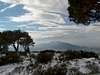
Imittós is a three season mountain, in the sense that it is rarely covered with snow. It sees 5-10 days of snowfall every year but it never takes more than one sunny day for all the snow to melt.
Early in the summer the trails that move through forest are pleasant, but in August you would be better off swiming in a nearby beach. North facing craggs make rock-climbing bareable in the summer.
Camping
Camping on Imittós isn't required since the longest route (crossing the hole mountain) takes 6hrs. Also at any time you are no more than 1-1½ hours away from the city streets.
Mountain Conditions
Ancient Athenians used to forecast the weather by looking at the peak of Imittós. So, checking the weather report for Athens in the news or the National Observatory of Athens will do.
General 72hr forecast for Athens. Courtesy of the National Observatory of Athens
 |
Literature
 | Anavasi Editions: Map 1.2: "Northern Imittos", Topo 10 series in 1:10.000 scale. Available at UK Amazon Map 1.22: "Central Imittos", Topo 10 series in 1:10.000 scale. Available at UK Amazon Both are very good maps. |
| Climbing in Athens by Dimitris Titopoulos - Paul Bailey (Greek & English). Published by the Mountaineering Club of Athens (site only in Greek). The second edition is in press. | |
 | Attica Rock by Yiannis Alliyiannis |