
|
|
Mountain/Rock |
|---|---|
|
|
48.58000°N / 66.01°W |
|
|
3740 ft / 1140 m |
|
|
Overview
This is the last peak from the Gaspe region that I am going to submit... mostly becasue its the last peak I know anything at all about and because the area now has adequate representation here on SP.Mont Xalibu is located in the National Park de Gaspesie in the McGerrigle section of the Chic Chocs. Mont Xalibu is one of the higher peaks in the park rising to a healthy 1130m, yet it sees only a moderate amount of activity compared to its neighbour Jacques Cartier. In the winter Xalibu is a more popular destination because its steep, virgin slopes appeal to backcountry skiers. The view of Xalibu from the summit of Jacques Cartier also draws many skiers and hikers alike to want to visit its craggy slopes.
Mont Xalibu is named in honour of the caribou that inhabit the region. The name Xalibu is the Algonquin word for caribou which means 'he who scartches the earth for food'. While the peak is named in honour of the caribou it also comes by the name honestly as the peak is a popular haven amongst several of the small bands that live in the park. Xalibu is located to the southwest of Jacques Cartier and due north of Mont Richardson. Xalibu is one of the most rugged peaks in the Chic Chocs; its western slopes are some of the steepest and craggiest in the park.
The Chic Chocs are the northern extension of the Appalachian Mountains, and contain over 25 peaks 1000m or higher.... making it quite possibly southeastern Canada's most mountainous area. The Chic Chocs are known for their steep ridges and broad, flat summit plateaus. The summits of all of the higher peaks are bereft of trees, containing only tundra, ground hugging plants and broken, weathered rock.
Mont Xalibu is usually climbed in conjunction with Jacques Cartier via the McGerrigle Trail. The trip is 35km roundtrip and usually requires an overnight stay at the Tetras Sheter located between the summits of Cartier and Xalibu. This is one of the most demanding hikes in the park, and offers some of the best scenery around.
From the Tetras Shelter (located near Lac Samuel Cote)its a 20km hike to the summit and then return to the La Galene parking lot at the Park Info. Center. The trail rises about 650m from the shelter to the summit, making the hike in places surprisingly demanding (for the Chic Chocs).
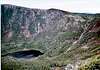
From the summit the views are breathtaking. You can drink in beautiful views of Cartier, Richardson and distant Mont Albert. Also the views of the Riviere-Ste-Anne Valley and Lac aux Americains are particularly impressive. You can also make out the glistening waters of the St. Lawrence on especially clear days.
 |  |  |  |  |
Getting There
From Quebec City it takes 5-5.5 hours by car to get to the park Information Center located in the heart of the Provincial Park de la Gaspesie. Take highway 73 south to highway 20 east (the Trans-Canada highway). You will stay on this highway for three hours until you reach Riviere-du-Loup where the Trans-Canada branches south into New Brunswick. In Riviere-du-Lopu jump on highway 132 east, you will remain on this road for 1.5 hours until you reach Ste-Ane-des-Monts passing through Rimouski and Matene along the way. From Ste-Anne take route 299 for 40km until you reach the Park Information center located at the heart of the park.The mountain trails are open in the summer from June 24 to September 30 and then re-open after Christmas, before closing again in the spring when the caribou return to the main peaks region. The animals are very sensitive to to people and their needs come first as this is one of the last pockets of woodland caribou in south-eastern Canada.
The route to the summit follows the McGerrigle Trail and starts at the Tetras Shelter located near Lake Samuel Cote. From there is a 20km roundtrip to the summit and then back to the Park Info. Center. The trail has some tricky, steep sections and involves clambering up and over some interesting craggy sections... similar to what may encounter on Mont Albert.
If interested in summitting both jacques Cartier and Xalibu, come prepared to spend the night at the Tetras Shelter or haul from sunrise to sunset as it a heck of a slog. The trail is 35km roundtrip (maybe even closer to 40) and should be taken seriously despite not just for its length, but also for its ruggedness.
 |  |  |
Red Tape
To use the trails one must purchase a day permit which costs between $6-8. There are 4 designated areas near the main peaks region where one can camp. In winter it costs $18 per night and in the summer it costs $21 per night per site. There are also huts on some of the mountains which costs $20 per night per person.For information on shelters one can call 1 800 665 6527. For Park information one can call 1 418 763 7811 or 1 418 763 3181. You can also email for information at parc.gaspesie@sepaq.com. For more information on the park you can check www.sepaq.com which is the official website for Quebec's parks. SEPAQ is an acronym which stands for the Society for the establishment of clean (plein in french) air.
When To Climb
The best time to the visit the park depends on the type of experience you are looking for. If you wish to cross country ski or snowshoe up to the summit and enjoy pristine winter weather at its finest, then the best time to visit is from January to March.If one is wishing to visit the park during more temperate times then the best time to visit (the only real time) is from June 24 to September 30. when the mountain trails are open.
The temperature can still drop below freezing up above the trees so come prepared for weather extremes; also serious storms frequent the region throughout the year so be sure to know the weather before you leave. For info. on trails you can call 1 866 727 2427.
Camping
Camping is allowed in the park, the prices are already outlined in the Red tape section and the necessary phone numbers are provided there as well.There are 4 major campgrounds in the park:
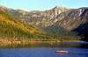
La Riviere has 40 sites and offers access to canoeing and easy hiking trails.
Mont Albert has 82 sites and offers easy access to many of the major mountain trails. This is one of the two recommended sites for those wanting to get away from the droves of family campers that can be found in the park... though the only way to avoid them entirely is to stay at one of the huts.
Lac Cascapedia has 74 sites and offers access to canoeing and moderate hiking trails.
Mt. Jacques Cartier is the other recommended site with access to several of the other mountain trails. It offers 27 semi-primitve sites and is perhaps the best place to camp if one needs to bunk down for the night.
Mountain Conditions
To find out the current weather condtions for the park and the long term forecast you can visit www.theweathernetwork.com and check the Parks forecast for Gaspe. You can also find out weather condtions for several of the nearby cities such as Ste-Anne-des-Monts or New Richmond.Also weather conditions can be found on the SEPAQ website if one checks for the specific park you are looking for.
Flora and Fauna
Over 500 woodland caribou call the park home and you can sometimes spot extended groups of up to a dozen together at one time. The park is also home to Virginia deer and moose... making it one of the few remaining places where these three large grazing animals inhabit the same area. The park is also home to black bear, wolves, coyotes and foxes. There are also 150 species of birds in the park including golden and bald eagles as well as several species of hawks and falcons.When hiking up the mountain trail it is not uncommon to pass through four vegetation zones. The tree line is very low, between 750-900 meters, and all of the sumits are covered in tundra. Though on the summits there are over 150 varieties of plants that are usually only found much further north.
 |