

-
 27697 Hits
-
 88.83% Score
-
 28 Votes
|
|
Mountain/Rock |
|---|---|
|
|
43.84400°N / 103.586°W |
|
|
Download GPX » View Route on Map |
|
|
Custer |
|
|
7000 ft / 2134 m |
|
|
Overview
Located in the famous Black Hills of South Dakota, Sylvan Peak is only about 4 air-miles west of the state highpoint at Black Elk Peak, and itself is the highpoint of Custer County. A thickly-forested peak, the summit ridge features many gigantic stone spires and cliffs, which make for interesting views and some hiking challenges, although the usual route to the top requires nothing more than simple scrambling at worst.
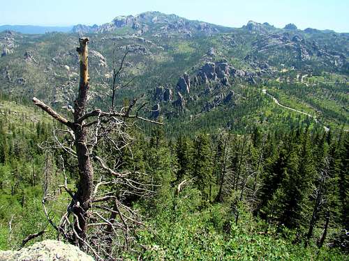
The usual hiking route is fairly short - about 1.5 miles one way with almost 800 feet in altitude gain from the parking area. However, most of the route is through tangled forest and requires attention to detail to stay on route. Sylvan Peak has not escaped the pine beetle devastation of forests in the western USA. To compound that, Winter Storm Atlas in 2013 downed many more trees, increasing the deadfall on Sylvan Peak. There are some small aspen groves on the mountain and with the destruction of parts of the pine forest, this mountain will likely see an increase in aspen over the next 20 years.
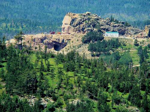
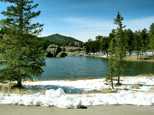
Sylvan Peak is not heavily promoted and probably does not see more than a handful of visitors per year, mainly county highpoint enthusiasts or Black Hills residents desiring a challenge. Summit views of Black Elk Peak, Little Devils Tower and Cathedral Spires are outstanding. Also clearly visible nearby are St. Elmo Peak to the north and Buckhorn Mountain to the south-southwest. The Crazy Horse Monument is located to the west-southwest. For those who would like to avoid crowded trails, who enjoy off-trail hiking, and who like a little solitude in reaching one of the Black Hills few 7,000-foot summits, this summit is a solid bet.
Getting There & Route
If coming from Custer, head north on SD-89 about 6 miles to the 89/87 junction. Go left onto SD-87 a little less than a mile to the pullout, on your left.If coming from the US-16/SD-87 junction (i.e. from the Crazy Horse and Rushmore Monuments), go south on SD-87 about 5 miles to the pullout. Steep switchbacks occur at about 3.5 miles, and the short tunnel is passed at about 4.5 miles.The “trailhead” is at a pullout and gate along highway SD-87 just under a mile north of the junction with SD-89, the road one normally takes to the Black Elk Peak trailheads (#9 and #4) at Sylvan Lake. The pullout is about 0.5 mile south of a short tunnel and will be on the west side of the road. There is now room for at least a dozen vehicles, due to recent parking lot work. Please be sure to park in such a way that you do not block the gate.
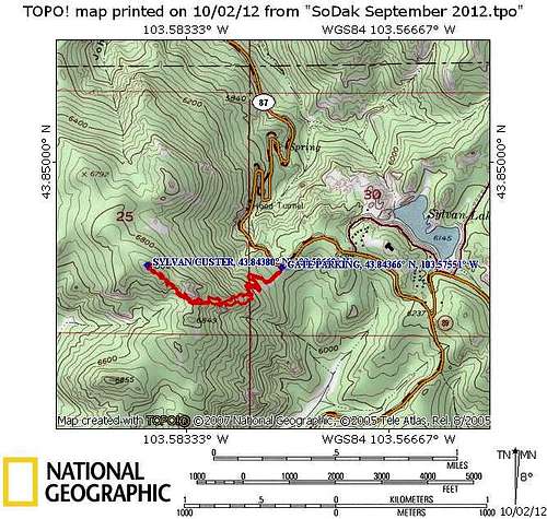
The usual route up the mountain is shown on the map on this page. It utilizes a short road up to a water reservoir building. From there on it is a bushwhack to the summit. At the water supply building, one can see two massive rock formations up the slope to the southwest. Climbers can head for these and pass between them as they go on up the center of the ridge toward the summit. Many choose to follow the ridgeline on the south side because of a little less vegetation and a little more light. There is a massive rock formation on the ridge that fools some climbers into thinking that is the summit. While it is fun to climb, getting to the top of that rock will quickly reveal there is still further to go to get to the true summit block. By patiently sticking to the top to the ridge, one will eventually get to the summit, and that same ridge will help guide the route back down..
The GPX file, attached, outlines the route to the summit from SD-87. Expect 2.1 miles roundtrip, and allow 90 minutes (roundtrip) at a moderate pace.
Red Tape
No fees or permits are required. There are no signs prohibiting access at the gate. Public access is allowed, just not promoted. Sylvan Peak is on public lands managed by the national forest service.Please note that the parking lot on the Highway 87 turnout is technically in Custer State Park. For the most part, they do not have any different restrictions, other than a prohibition against carrying handguns.
The forest service office in Custer can be reached at: 605-673-9200
The forest service district ranger's office can be reached at: 605-673-4853
The main office in Custer State Park can be reached at: 605-255-4515
When To Climb
The winter snows may make the roads impassable at times, and the route messy. Highway 87, from Highway 16A to Sylvan Lake, is usually closed from about November 1 through April 1. But, after roads are cleared following a storm, 87 is open from Hill City to Sylvan Lake. Highway 89 from Custer to Sylvan Lake is normally open all year. The best times to climb are usually from late April to late October. Summer can be pretty warm in the Black Hills, though at Sylvan Peak's altitude it will rarely exceed the high 80's. Beware of thunderstorms that can develop quickly. Mid-afternoon lightning can be treacherous.
For those who want to hike during fall colors season, late September through mid-October are the best times. But, significant snowfall can also occur at those times, sometimes with not much advance warning.
Camping
Camping and lodging can be found near Black Elk Peak and Sylvan Lake. The nearest towns are Custer and Hill City, though the whole Black Hills region has many camping areas and many inexpensive hotels in Rapid City, Hot Springs, Deadwood, Lead, Keystone, and Sturgis.
Links to camping and lodging very close to Sylvan Peak include these:
Mountain Conditions
For the latest weather forecast and conditions for the area, click here:
Weather Information for Sylvan Peak - Custer, South Dakota area
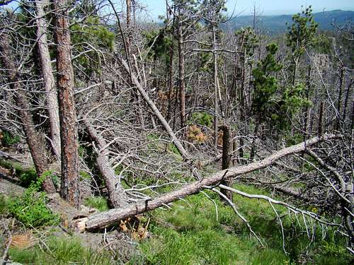
The pine beetle infestations plaguing the Black Hills, have hit Sylvan Peak pretty hard in recent years. This means snag dangers for years to come. Winter Storm Atlas, in October 2013, caused widespread damage to the Black Hills National Forest. Many trails were almost impassable, due to downed trees. This took the forest service a long time to clean up. Check out the link to the Custer Forest Service office for the latest conditions at this link:
Custer, SD Forest Service Office