
|
|
Mountain/Rock |
|---|---|
|
|
43.12768°N / 19.03317°E |
|
|
Hiking, Sport Climbing, Big Wall |
|
|
Spring, Summer, Fall |
|
|
8274 ft / 2522 m |
|
|
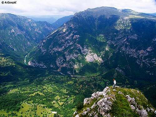
Bobotov Kuk (2522m)
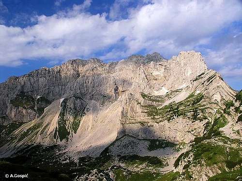
Bezimeni Vrh, Bobotov Kuk and Djevojka create a wall called Soa Nebeska
Bobotov Kuk is highest peak of Durmitor mountain and 4th highest peak in Monte Negro. But in many publications you will find info that Bobotov Kuk is highest in Monte Negro. It is because those 3 peaks that are higher are placed in Prokletije massif and are on the border with Albania while on the other side Durmitor is in central Monte Negro, it is beauty symbol of the country and because of that closest to the heart of Montenegrins.
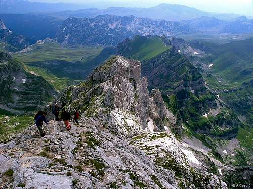
Position: Its rocky pyramid is placed in the central part of the mountain and roughly in the middle of the main crest which stretches in NW-SE direction. Like a high throne it overlooks magnificent surroundings. From three sides its neighbors are attractive and equally sharp and wild rocky peaks. Two of those three peaks are in main crest: on the NW is Bezimeni Vrh (2487m), while on the SE is Lucin Vrh (2396m), which is separated from Bobotov Kuk by deep Velika Privija pass (2351m). On the SW, separated by narrow Skrcki Pogled pass, is Soa or Djevojka (2440m), wild rocky peak which stands on the beginning of streak of peaks that are perpendicular on main crest.
Bobotov Kuk above Velika Privija
Peak & Surroundings: Northern and eastern sides of here compact summit pyramid, which is around 200m high, rises above steep scree slopes that descent into large rocky basin Valoviti Do (between 2000 and 2100m), which is strewn with huge boulders and partially covered with snow remains whole summer. Western side of Bobotov Kuk is most impressive. Together with Bezimeni Vrh and Djevojka peaks Bobotov Kuk, which is between them, form biggest wall (sort of amphitheater) of Durmitor. It is around 400m high and almost 2km wide. Below the wall are immense scree slopes, equally high, that descent steeply towards the bottom of amazing Skrka valley, which contains Veliko Skrcko Jezero (1686m) and Malo Skrcko Jezero (1711m) lakes. This is most beautiful part of Durmitor! On the south Bobotov Kuk falls steeply towards the basin of Zeleni Vir (2028m) lake, which is placed at the bottom of the beautiful amphitheater above which walls of Bobotov Kuk, Lucin Vrh, Minin Bogaz (2387m) stretch. South of the lake are Zupci (2309m), fantastic string of cliffs that look like teeth of some dangerous dinosaur. Lower 300m of this side of Bobotov Kuk is mix of steep rocky terrain with lot of grass and scree. Above it is summit pyramid.
Short history: Due to isolated position, wild surroundings and volatile history of continued liberation struggle Durmitor and its highest peak were very lately discovered, both scientifically and esthetically. Scientists came first, of course. They were very rare. First of them was Amie Boue who wrote about geology of Durmitor in his book ‘Geological Excursion in Turkish Europe’ in 1840m. In 1883 Bobotov Kuk was first climbed by Dr. O.Baumann. Those were the years of more intensified scientific research of Durmitor. In 1895 German geographer Kurt Hussert wrote first book about physical geography of Durmitor. At the end of 19th century Serbian botanist Josip Pancic discovered many endemic and rare floral species. Extraordinary karts phenomena on Durmitor was first described by Serbian scientist Jovan Cvijic, who was then known in the world after his Das Karstphanomen dissertation from 1893. Then came volatile part of early 20th century and everything was stopped for a while. First organized mountaineering group visited Durmitor in 1926. They were members of Sljeme club from Zagreb, Croatia. In the same year first climbs in the eastern face of Bobotov Kuk were done. In 1931 2 Austrians, Bauer and Obersteiner, did first winter ascent via NW ridge of Bezimeni Vrh and some other peaks. In 1933 group of Slovenian climbers first climbed highest faces of Durmitor, those of Bezimeni Vrh and Bobotov Kuk above Skrka valley. Group of Slovenians also did first winter climbs in the faces of highest peaks of Durmitor in 1940. Only after the II World War Durmitor became well know destination for tourists, hikers, climbers and skiers.
Today: Durmitor is quite visited and well marked mountain for hikers during short summer. Bobotov Kuk is probably most visited peak, if we exclude Savin Kuk, whose summit has almost been reached by chair lift. Bobotov Kuk can be ascended via 4 different routes. 3 that lead from south and west are: Sedlo route, which begins on Sedlo pass, highest point of Zabljak – Trsa macadam road, Dobri Do route, which also has a trailhead on Zabljak – Trsa route, and Skrka route, which leads from famous Skrka valley. These 3 routes meet at Zeleni Vir lake and continue as one route till the Velika Privija pass. On the pass they join the only northeastern approach which leads from Zabljak. In the mid part this route has 2 variations, via Ledena Pecina cave or via Lokvice valley. Zabljak approach is considered as classical. See best combinations in hike advices section.
On Durmitor there are only 3 mountain objects: mountain hut in Skrcka Dolina valley, refuge in Lokvice valley and bivouac in Velika Kalica valley. Latest one is not suitable for Bobotov Kuk visit. Their capacity is greatly insufficient. There was also a refuge on Kleknata Glavica, rocky head at the edge of Valoviti Do basin, just below Bobotov Kuk, but it burned and is still waiting to be rebuilt. In the wider area there is also mountaineering hut in the Susica canyon but it is not suitable as base to visit central Durmitor. Most hikers and visitors are placed in hotels and private apartments in Zabljak town, at the NE edge of central part of Durmitor. Because heart of Durmitor is relatively small and suitable for daily trips from Zabljak this is good because mountain is not ‘polluted’ by unnecessary objects and still everything is close.
 |
 |
 |
 |
 |
 |
 |
Summit View
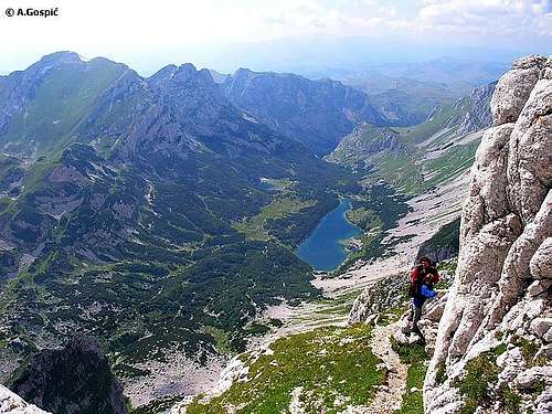
Prutas and Skrka valley from Bobotov Kuk summit climb
View from Bobotov Kuk is fantastic! Peak dominates surroundings so view stretches freely in all directions, at least hundred kilometers. On all sides, as far as eye can see, mountains rise but none is higher than your standing point. Most of Montenegrin mountains are visible from Bobotov Kuk. Farthest visible points are: Kopaonik (2017m) in Serbia (E, 150km), Lovcen (1749m) above Montenegrin coast (S, 100km), Cvrsnica (2222m) in Bosnia Herzegovina (W, 125km) and Tara (1544m) in Serbia (N, 100km). But most amazing are close views of Durmitor’s diverse terrain and canyons. Of ‘closer’ surroundings it is worth to mention:
W: below your feet is amazing Skrka valley which harbors two deep blue lakes. From the opposite side it is closed by green wall which is dominated by Prutas (2393m), largest peak on Durmitor. Through the opening of Skrka valley, which is beginning of Susica canyon, view extends towards large and high undulating grassland of Pivska Planina mountain. Behind it, divided by the Piva River canyon, high group of mountains rise. Those are: Volujak (2336m), Bioc (2397m) and Maglic (2388m). Maglic is border mountain with Bosnia Herzegovina and its highest peak of, here it show Montenegrin side.
N: below your feet is large basin Valoviti Do, strewn with large boulders and partially covered with snow remains during whole summer. Behind it is Rbatina (2401m) and further back SE reddish face of Crvena Greda (2184m). Behind the Tara River canyon is grassy Ljubisnja (2238m) mountain. Little bit right, towards NE, Valoviti Do is still below your feet. Central part of Durmitor gradually descends till it melts into huge grassland that Jezerska Povrs plateau is. Where central part and plateau touch scattered houses of Zabljak town stand. Behind plateau, further back, is Tara River canyon.
E: cliffs of Lucin Vrh (2396m) are in foreground. Left of them is eastern direction. Long ridge of Medjed (2287m) is hardly recognizable from this perspective as it is melted into the background. Behind it is dome Savin Kuk (2313m) with undulating grassland and forests of Jezerska Povrs plaeau and large Sinjajevina (2277m) mountain. Right of Savin Kuk long NW wall of Sljeme (2455m) stretches. Below it are numerous snow fields. On the right it ends with rounded Milosev Tok (2426m). Right of Milosev Tok begins SE direction and Durmitor changes its color from white to green. In the foreground are beautiful Zupci (2309m), (small teeth) 14 lined up smooth and sharp towers. Behind them are green (grass) and white (twisted rocky layers) waves of Vjetrna Brda (2231m) and elegant Sedlena Greda (2227m) further back, with its long and sharp summit ridge. Behind Sedlena Greda are high green or rocky peaks of central Montenegrin mountains.
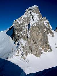
 Lucin Vrh winter view towards S-SE (similar to Bobotov Kuk view)
S: right of Sedlena Greda is white (rock) and dark green (dwarf pine) NE side of Boljska Greda (2091m). On its right end is sharper peak with high face. That is just a glimpse of huge 700m high SW face which is few kilometers wide and falls into the Komarnica canyon. Right of that sharp peak is wider opening. That is beginning of Komarnica canyon. In front of it is large undulating grassland of Dobri Do. Behind opening, further back, is wild northern side of Vojnik (1997m) mountain. Right of the opening is Lojanik (2091m), with its white and dark green side and exact same height it looks like copy of Boljska Greda, which is left of Komarnica canyon. Behind Lojanik is grassland of Pivska Planina with Golija (1942m) mountain further behind.
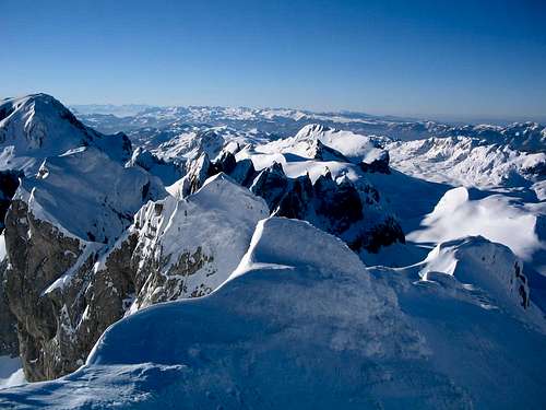
 Above Durmitor splendor
 |
 |
 |
 |
 |
 |
Hike Advices
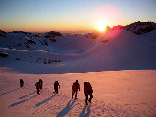 Early morning start from Valoviti Do
Both northern and southern Bobotov Kuk approaches are so beautiful and very different that it is hard to recommend one. Southern approach leads over open grassy/rocky terrain while northern begins in dense conifer forest at Crno Jezero Lake and ends in bare rock land above Valoviti Do basin. Most beautiful way to climb Bobotov Kuk is to cross whole central Durmitor in a daily trip, using one route to go up and the other to go down. Zabljak (northern) approach is considered to be classic. It is much longer and lasts over 5 hours while two southern approaches last between 2.30 (from Dobri Do) and 3 hours (from Sedlo). If you are placed in Zabljak probably best combination is to leave car parked at Crno Jezero Lake and take taxi to Sedlo pass (1907m) where classic southern approach begins. In 2004 summer taxi from Zabljak to Sedlo pass cost 20€. To Dobri Do trailhead, which is 3km further down the road, must be just a bit more. From Bobotov Kuk use Zabljak route to descent to your car at Crno jezero.
Here is one beautiful 2day combination. Take taxi to Dobri Do trailhead of Skrcka Jezera lakes route. Via Skrcko Zdrijelo pass climb Prutas (2393m). This route has best panoramas on Durmitor! From Prutas descent to valley and the lakes and sleep over at the hut. Tomorrow over Samar pass join two southern approaches at Zeleni Vir Lake. From there continue to the summit and descent to Crno Jezero via Zabljak route.
 |
 |
 |
 |
 |
 |
Short About Durmitor
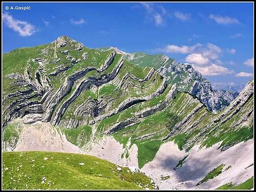
Stit and its famous Zeleni Pasovi (Green Layers)
Durmitor is mountain of dreams! Some, especially Montenegrins, say Durmitor is most beautiful mountain in former Yugoslavia. To claim that status in a country that was so rich with natural diversity and fantastic mountains is not an easy task. Slovenians would certainly dispute saying Julian Alps are more beautiful or Croats would say maybe our Velebit is more beautiful. Probably none is right as it is matter of taste. But certainly those 3 mountains, with their natural richness, diversity and value probably stick above numerous other beautiful mountains of ex YU.
Beauty gathered on a relatively small place, that Durmitor is, is simply breathtaking. Mountain is placed in the NW corner of Monte Negro and as most of Dinaric Alps, to which it belongs, is made of limestone. It is second highest mountain of Dinaric Alps, behind Prokletije mountains. Durmitor, in wider sense, is surrounded by deep valleys and canyons from all but one side. On the N is deepest canyon in Europe, the one of amazing Tara river. On the W is canyon of Piva river and Pivska Planina mountain, which is in a way part of Durmitor. On the S canyon of Komarnica river, which later flows into Piva river, and valley in which is Savnik town. Above those canyons rises Jezerska Povrs (Plateau of lakes), huge open undulating grassland. Only on the E Jezerska Povrs doesn’t end like cut off by a canyon but is closed by nearby Sinjajevina mountain. Central part of Durmitor rises around 1000-1100m above Jezerska Povrs, as plateau is at around 1400m. Central part of Durmitor is amazing and magical mountain world of deep glacial valleys, sharp, soft or cut off peaks, twisted and distorted rock layers, needles, lakes, high pastures and fluorescent green slopes, all created by wild tectonics and glacial work as mountain was heavily glaciated during last Ice Age. Glaciers covered 230 square km’s of Durmitor and on some places descend all the way to only 700m of altitude.

Cuvarkuca
Flora is also very rich. Green slopes of Durmitor are in summer also amazing carpet of flowers which represent almost all colors of spectrum. On Durmitor there are 10 endemic species! Here are few: Glisicevo Zvonce (Edraianthus Glisicii), Durmitorska Divizma (Verbascum Durmitoreum), Durmutorski Trputac (Plantago Durmitorea) and so on.
Central part of Durmitor is placed above Jezerska Povrs plateau, which is huge, almost treeless, undulating grassland. On it there are very few trees, mostly of beech. Along the northern edge of central part conifer forest grows. It mostly consists of spruce and fir. It climbs up the mountain but also covers part of the plateau, closer to central part. At around 1600m it begins to mix with beech, which ends at around 1750m. Above it is area of dwarf pine and grass, later bare rock. Eastern side also has some beech along the edge of plateau but it doesn’t ascend up the slopes, which are mostly grassy with occasional cliffs, rock and scree. Southern and western sides of central part are completely treeless. These are beautiful fluorescent grassy slopes mixed with cliffs, rock and scree. Higher up are bare peaks.
Sides of Jezerska Povrs plateau, which descent or fall into canyons and valleys of rivers that surround Durmitor, are partially or mostly under beech, spruce, fir, pine, maple and oak forests.
Climate of Durmitor is very harsh! During the year mountain receives 1750mm of precipitation. If it wasn’t made of limestone that would be sufficient for many surface flows but everything goes underground. Most part of the year Durmitor is under deep snow. There is no data for high parts of the mountain but in Zabljak town, at the edge of central part, snow is on the ground around 5 months. Highest snow depth measured in Zabljak was 198cm. These numbers are way higher in higher parts of Durmitor as there are several meters of snow each season. Even in August one can see remains all over the central part, even on Sun exposed southern slopes, as low as 2000m. High part of Durmitor is under snow from October to June while snow can fall in any time of the year. In Velika Kalica valley, under the cliffs of Sljeme, last remains of glaciations stand in form of Debeli Namet snowfield. Annual temperature average for high parts of Durmitor is 0°C. Lowest monthly average has January, -8°C while during same month Zabljak has average of -5°C. Highest monthly average is in July, 8°C, on Zabljak 14°C.
Because of its amazing beauty and value in every sense Durmitor was declared a national park in 1952 (there are 4 NP’s in Monte Negro today). In 1978 unique canyon of Tara river was added to the national park as it is integral part of Durmitor. Since then national park covers the area of 350 square km’s. In 1977 UNESCO added Tara river to the network of ecological preserves of the world. In 1980 UNESCO declared Durmitor and canyon of Tara a part of world heritage and is protected as such by the organization.
Durmitor has around 50 peaks that rise above 2000m mark. Here is list of the highest ones:

Zupci
01) Bobotov Kuk (2522m)
02) Bezimeni Vrh (2487m)
03) Sljeme (2455m)
04) Soa or Djevojka (2440m)
05) Milosev Tok (2426m)
06) Bandijerna (2409m)
07) Rbatina (2401m)
08) Lucin Vrh (2396m)
09) Prutas (2393m)
10) Minin Bogaz (2387m)
11) Planinica (2330m)
12) Kobilja Glava (2321m)
13) Savin Kuk (2313m)
14) Supljika (2310m)
15) Zupci (2309m)
16) Obla Glava (2303m)
17) Terzin Bogaz (2303m)
18) Gruda (2302m)
19) Medjed (2287m)
20) Suva Rtina (2284m)
21) V.Previja (2255)
22) Stit (2248m)
23) Suvi Klek (2238m)
24) Vjetrna Brda (2231m)
25) Sedlena Greda (2227m)
Name Durmitor, it seams, comes from Celtic phrase Dru-mi-tor what means water-from-mountain. Before Slavs came here settlers were Illyrians and Celts. With time they were assimilated by Slavs.
Hystory of People. Durmitor area is mostly settled by Drobnjaci tribe of Slavic people. According to word of mouth there are two versions how they came to Durmitor area. One says they are ancestors of big Slavic tribe Novljani who came to today’s Monte Negro in 8th century. Other says they came here from Kosovo and Turkish repression. Drobnjaci permanently settled on Durmitor in 16th century. History of Drobnjak’s is one bloody epic, said Nikifor Ducic in 1865 and who could have imagine what was yet to come. People of Durmitor, as on most of Balkan’s, always had to fight for their freedom. For hundreds of years they fought against Turks, who many times killed entire families, villages, took away cattle, and burned everything. This area also paid heavy price during II world war. Once Germans killed 400 persons in a day, burned 5500 houses and took away 67000 cattle. Zabljak was 3 times occupied by Italians or Germans and 3 times liberated, last time on September 17th 1943. 1028 people lost their lives in Partisans and 1413 civilians were killed only on Durmitor area and we know how rarely populated whole area is. 14 fighters from Durmitor were declared national heroes.
 |
 |
 |
 |
 |
 |
Durmitor Lakes
In last ice age Durmitor was heavily glaciated. When ice melted 18 beautiful lakes where born. People call them Gorske Oci or Mountain Eyes. They are scattered all over mountain and Jezerska Povrs (plateau of lakes). Lakes add even more beauty to what is already amazing mountain. Here is list of lakes, according to altitude at which they are placed (in second brackets is their depth), and something about most important ones.
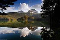
Crno Jezero (Black lake)
01) Zeleni Vir (2028m) (2.5m)
02) Jablan Jezero (1791m) (8.5m)
03) Malo Skrcko Jezero (1711m) (15.2m)
04) Valovito jezero (1695m) (3.5m)
05) Vir u Lokvicama (1693m) (4m)
06) Veliko Skrcko Jezero (1686m) (17.2m)
07) Srablje Jezero (1623m) (2.5m)
08) Modro Jezero (1609m) (3.3m)
09) Suva Lokva (1593m) (2.5m)
10) Zminje Jezero (1520m) (7.7m)
11) Barno Jezero (1489m) (2m)
12) Poscensko Jezero (1487) (3.6m)
13) Zabojsko Jezero (1477m) (18.8m)
14) Crno Jezero (1416m) (49m)
15) Vrazje Jezero (1411m) (10.6m)
16) Riblje Jezero (1409m) (5.5m)
17) Zminicko Jezero (1285m) (3.8m)
18) Susicko Jezero (1150m) (5m)
 Crno Jezero (1416m) (Black Lake) is second largest glacial lake in Monte Negro and largest on Durmitor. It enjoys legendary status and rightfully so. There is no book about Monte Negro or tourist brochure without its photo. Safely dipped into deep conifer forest with perfect background provided by Savin Kuk and Medjed peaks, Crno Jezero deserves every superlative it gets. It got its name because of the conifer forests that surround it. Around the lake build path goes. When staying in Zabljak walk around Crno Jezero is perfect way to end a day. From center of Zabljak road leads 3km to Crno Jezero. Last 800m are closed for traffic, there is parking there. Crno Jezero (1416m) (Black Lake) is second largest glacial lake in Monte Negro and largest on Durmitor. It enjoys legendary status and rightfully so. There is no book about Monte Negro or tourist brochure without its photo. Safely dipped into deep conifer forest with perfect background provided by Savin Kuk and Medjed peaks, Crno Jezero deserves every superlative it gets. It got its name because of the conifer forests that surround it. Around the lake build path goes. When staying in Zabljak walk around Crno Jezero is perfect way to end a day. From center of Zabljak road leads 3km to Crno Jezero. Last 800m are closed for traffic, there is parking there.Crno Jezero is placed on the NE side of rounded central part of the mountain, at the edge of Jezerska Povrs plateau, 3km from center of Zabljak town. By two peninsulas lake is divided in two parts: smaller and larger lake. Between peninsulas is narrow and shallow passage Struga which connects them. Sometimes during summers water level can drop a bit, leaving Struga dry and Crno Jezero split in two. Lake is 1155m long and 810m wide. Larger lake is 855m long and 615m wide, while smaller lake is 605m long and 400m wide. Length of the coast line at maximum water level is 4395m. Depth of the smaller lake is 49m and 24.5m of the larger lake. In mid summer water temperature in upper layers along the coast can reach 20°C or more so is suitable for swimming. Lake is filled by few creeks and sources of which most powerful is Celina source and the steep slope of Medjed peak. In time of rapid snow melting appearance of the water is accompanied by powerful blast, like a mine explosion. At such times when water tributaries are abundant Crno Jezero looses water via Otoka creek at NE corner and flows towards Zabljak but goes underground few kilometers behind the lake, on the meadows below Pitomine hills. |
 Skrcka Jezera (Lakes of Skrka) are placed in deepest and most beautiful glacial valley on Durmitor, Skrka valley, which is from 3 sides surrounded by high and wild peaks of various colors and textures, including highest one who shows its most powerful face above Skrka, Bobotov Kuk (2522m), and immense scree slopes. It is only open towards the canyon of Susica on the NW and this was direction where Skrka glacier headed. Veliko Jezero (1686m) (Large Lake) is elongated and placed in the middle of the valley. It is 580m long and up to 165m wide, 17m deep and has 1720m long coastline. Part of the coast is under stunted beech trees. Malo Jezero (1711m) (Small Lake) is rounded and placed below the cliffs of mighty Prutas (2393m). It is 225m long and up to 94m wide, 15m deep and has 440m long coastline. Between the lakes is grassy plateau on which mountaineering hut stands. Beginning of the Susica canyon is few hundred meters below the edge of Skrka valley, under the steep face. Skakala waterfall decorates the face during stronger waters, which comes underground from Veliko Jezero. Skrcka Jezera (Lakes of Skrka) are placed in deepest and most beautiful glacial valley on Durmitor, Skrka valley, which is from 3 sides surrounded by high and wild peaks of various colors and textures, including highest one who shows its most powerful face above Skrka, Bobotov Kuk (2522m), and immense scree slopes. It is only open towards the canyon of Susica on the NW and this was direction where Skrka glacier headed. Veliko Jezero (1686m) (Large Lake) is elongated and placed in the middle of the valley. It is 580m long and up to 165m wide, 17m deep and has 1720m long coastline. Part of the coast is under stunted beech trees. Malo Jezero (1711m) (Small Lake) is rounded and placed below the cliffs of mighty Prutas (2393m). It is 225m long and up to 94m wide, 15m deep and has 440m long coastline. Between the lakes is grassy plateau on which mountaineering hut stands. Beginning of the Susica canyon is few hundred meters below the edge of Skrka valley, under the steep face. Skakala waterfall decorates the face during stronger waters, which comes underground from Veliko Jezero.Skrka valley is not easily accessible to non hikers as it is surrounded by mighty peaks. This is most beautiful corner of Durmitor mountain. |
Jablan Jezero (1791m) (Poplar Lake) is placed at the bottom of amphitheater which is formed by picturesque cliffs of Crvena Greda (2184m) and large scree slopes below it, on the N and W. From the other two sides it is surrounded by conifer forest. Lake is 255m long, 155m wide and up to 8.5m deep. Much of its 730m long coastline is made of smooth boulders.
Jablan Jezero is beautiful and highly recommended half day trip from Zabljak. If you add Crvena Greda it turns to most of the day trip which is well worth it because of fantastic panoramas from crvena Greda towards central part of Durmitor.
Zeleni Vir (2028m) (Green Whirlpool) is one of the smallest but highest placed lake on Durmitor. It fills the bottom of the highest part of Mlijecni Do glacial basin, a fantastic amphitheatre of wild peaks, scree slopes and huge boulders. Around the lake are: Djevojka (2440m), Bobotov Kuk (2522m), Lucin Vrh (2396m), Minin Bogaz (2387m) and fantastic Zupci (2309m) (teeth). Zeleni Vir is rounded lake with diameter of 80m. It is up to 2.5m deep and has green color.
All 3 southern Bobotov Kuk approaches meet at Zeleni Vir. Lake is great refreshment before the final push to the highest peak of Durmitor. During some summer it can dry out. On the northern shore, between the rocks just above the lake, is also water source.
 |
 |
 |
Tara River
On the edge of amazing Tara canyon
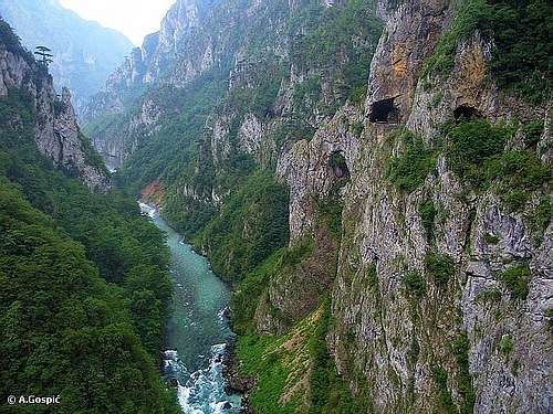
Tara, the name itself is a legend. There is so much more people around the world that have heard about Tara River than about Monte Negro. It is also called the jewel of Europe or tear of Europe and rightfully so. With the length of 140km Tara is longest river in Monte Negro. Tara springs in Komovi mountains, near the border with Albanija, on the east of Monte Negro. It generally flows towards northwest. Its last 80km, before it meets Piva river at Scepan Polje and they make Drina river, Tara spends in Europe’s deepest canyon, also called the Colorado of Europe. On some spots canyon is 1300m deep while below Veliki Stuoc (2104m) peak on Durmitor side of Tara’s canyon is 1600m high! Crystal clear waters of Tara, which have light blue and green color, made its canyon in rough limestone mountains even before the Ice Age. Water has carbon dioxide in it which turns calcium carbonate into calcium bicarbonate that dissolves in water.
Tara got its name after Autarijati tribe of Illyrian people that lived here before Slavs came.
In the beginning Tara flows towards north, through gentle and fertile valley between Sinjajevina mountain on the west and Bjelasica mountain on the east. It passes through towns of Kolasin and then Mojkovac where it suddenly turns towards west-northwest. Dozen kilometers after Mojkovac, after the spot where it is joined by Bistrica river, Tara enters its canyon which is a deep scar between Sinjajevina, Durmitor and Pivska Planina mountains on the south and Lisac, Obzir and Ljubisnja mountains on the north. Sides of the canyon are very steep; their upper edges are around 2-3km apart. On some spots even the river bed is very narrow. Near Bistrica, the Tara riverbed is so narrow that local people used to jump across it when necessary. Place is called Djavolje lazi (Devil’s lanes). Between the cliffs and scree slopes dense vegetation grows. With the altitude it changes. At lowest level hornbeam, ash, linden and elm grow, on some places beech too. Most interesting is black pine which grows from river banks to the edge of the canyon. On Crna Poda location trees reach height of 50m while some are up to 400 years old. Higher up oaks, maples and beeches take over while in highest areas of the canyon spruce, fir and beech are predominant trees.
Through first third of the canyon (30km) road leads from Mojkovac till the legendary bridge on Djurdjevica Tara where it joins Pljevlja – Zabljak road. During this stretch road is most of the time close to the river and this is the only place where those who have no rafting ambitions can get to know part of Tara’s canyon. Sides are on places very wild, rising 1000m above river. On sides, among cliffs, high black pines grow while on other places it is beech jungle along the river. After Djurdjevica Tara bridge canyon is hardly accessible as no roads descent into it and plateaus above the river are not very populated which means not too many roads above the river too. Only one road descends partially into the canyon, the one which leads from Zabljak to Tepca village that is scattered on the sides above Tara, which are here widest along whole canyon. Also 15km long road lead along the Tara from Scepan Polje border crossing with BiH. It is used for shortened version of rafting.
 Legendary bridge on Djurdjevica Tara was build between 1938 and 1940. Luckily it wasn’t destroyed in II world war. Its 5 elegant arches connect 2 banks of the river and Zabljak and Pljevlja towns. Bridge is 366m long. Arc above the river is widest and 150m above the river. Legendary bridge on Djurdjevica Tara was build between 1938 and 1940. Luckily it wasn’t destroyed in II world war. Its 5 elegant arches connect 2 banks of the river and Zabljak and Pljevlja towns. Bridge is 366m long. Arc above the river is widest and 150m above the river. |
 At the beginning of the canyon Tara is on 800m while it meets Piva River on altitude of 440m. During that 80km long stretch there are 40 rapids. Some of them are wild but canyon is safe for rafts or kayaks. Rafting on Tara is organized since 1964. Till some time ago river descents were organized on Splav. It is a raft made of 12 to 14 logs that are parallel and connected one to another in such way that front is bit narrower than back. Splav is rowed by brave and skilled people who used to transport timber in the lower course of the river this way. In the middle of it there were three benches which were stacked like square open towards front side. This was first class attraction as Splav could submerge completely into the water on wilder rapids and tourists would find themselves in the water up to waist. But these traditional rafts are now almost completely replaced by standard rubber rafts for 10 persons. Rafting is very popular tourist attraction and usually combined with Durmitor visit. Long rafting version lasts 3 days, it begins 3km upstream from Djurdjevica Tara bridge and ends on Scepan Polje where Tara and Piva rivers meet to form Drina river. Places to sleep are two terraces by the river called Radovan Luka and Brstanovica. Shorter version lasts 3 hours and begins 15km upstream from Scepan Polje. At the beginning of the canyon Tara is on 800m while it meets Piva River on altitude of 440m. During that 80km long stretch there are 40 rapids. Some of them are wild but canyon is safe for rafts or kayaks. Rafting on Tara is organized since 1964. Till some time ago river descents were organized on Splav. It is a raft made of 12 to 14 logs that are parallel and connected one to another in such way that front is bit narrower than back. Splav is rowed by brave and skilled people who used to transport timber in the lower course of the river this way. In the middle of it there were three benches which were stacked like square open towards front side. This was first class attraction as Splav could submerge completely into the water on wilder rapids and tourists would find themselves in the water up to waist. But these traditional rafts are now almost completely replaced by standard rubber rafts for 10 persons. Rafting is very popular tourist attraction and usually combined with Durmitor visit. Long rafting version lasts 3 days, it begins 3km upstream from Djurdjevica Tara bridge and ends on Scepan Polje where Tara and Piva rivers meet to form Drina river. Places to sleep are two terraces by the river called Radovan Luka and Brstanovica. Shorter version lasts 3 hours and begins 15km upstream from Scepan Polje. |
Sadly there are always stupid people so recently there are ideas to build a dam for hydro power plant on Tara! Considering that Tara and its canyon are world class attraction and immeasurable natural value, national park and area under protection from UNESCO this is nothing but sick idea worthy of war starting if it goes into realization. Currently there is action and petition signing in Monte Negro named Hocu Taru a ne Baru, which means I want Tara not a swamp!
But with the breath of huge relief there is good news to write now for the beauty of Monte Negro and Europe. The idea to make a dam which would turn the happy Tara into the static lake was abandoned! I want Tara not a swamp campaign called gave results! To strengthen the protection for the times to come there is now the idea to merge the Durmitor – Tara national park with Sutjeska national park, which is in neighboring Bosnia and Herzegovina. Idea has been backed up by the EU commissioner in Bosnia.
 |
 |
 |
 |
Piva River
Amazing Piva canyon, what is left of it
Piva is one of few spectacular rivers in Monte Negro. It flows in western part of the country finding its way through high mountains. Between them it carved spectacular canyon, over 1000m deep. Piva makes western border of wider Durmitor (2522m) area that includes Pivska Planina mountain (which is east of river) and also takes water from one of Durmitor’s rivers, Komarnica, on the south. West of the river are equally high Golija (1942m), Bioc (2397m) and Maglic (2388m) mountains. From its source Sinjac it used to flow 33km towards north till Scepan Polje where its waters are joined with those of Tara to form Drina river. Between 1967-1975 huge 220m high dam was build 10km upstream from Scepan Polje and spectacular 180m deep Pivsko Jezero lake was born but sadly river killed and lot of canyon submerged. Lake extends even into part of Komarnica river canyon. Well, not only canyon was submerged but also source of Piva and Pluzine town found themselves under water. Very important Pivski Manastir monastery was moved from Piva source to higher location and new Pluzine were built. Pivski Manastir monastery dates from 1573 and has 1260 square meters of very valuable frescoes, which were drawn in 1604 and 1605. It is dedicated to ‘Ascent of mother of God’. Its careful moving to higher location and reconstruction of frescoes, stone by stone, lasted over a decade.
Part of the road from Niksic town towards Scepan Polje border crossing with Bosnia Herzegovina leads through the canyon of Piva, along the Pivsko Jezero lake and later (behind the dam) through the rest of ‘how it originally looked’ canyon. This is spectacular and breathtaking drive. Beautiful mountains rise above the lake which has amazing blue color. First you are high above the lake and get the views of Durmitor behind the lake. At Pluzine town road descends into the side valley and continues by the lake. It enters the canyon of Piva behind the bridge that crosses it (Piva comes from right), few kilometers behind Pluzine, and now it gets even more beautiful. Road now goes through numerous rocky tunnels through the cliffs of the canyon, by the lake. Occasionally, on wider places, you see peaks which soar towards sky. Most spectacular part comes after the dam, through untouched canyon, where crystal clear green and blue Piva runs deep below fantastic road while cliffs tower wildly above.
 |
 |
 |
Zabljak
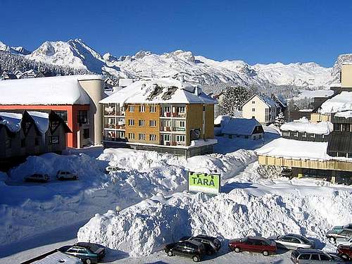
Winter on Zabljak
From tiny regional market and village Zabljak has grown into highest placed urban settlement on the Balkans. It is placed on the altitude of 1450m, at the NE foot of central part of Durmitor and at the edge of Jezerska Povrs plateau. Only larger buildings in Zabljak are hotels while private houses are quite small, which is unusual. Such houses, scattered on the green or white hills around center, look like picturesque models. Zabljak began to develop into urban settlement in 1871. Since then it has become best know and most loved mountain center of Monte Negro. Zabljak has few thousand inhabitants and everything small town needs. There are 6 hotels in a town and almost every house takes guests. Over 10 years of stagnation and crisis in whole country which followed after the dissolvent of former Yugoslavia led to deterioration of the state in which tourist objects on Zabljak are. Anyway one cannot expect Zermatt or St.Moritz type of accommodation here but Zabljak makes it up with the beauty of the landscape, warmth of the people and fantastic food, especially milk products. This also doesn’t mean accommodation is bad. In recent years things are gradually getting better so in couple of years one can only expect improvements. Around Zabljak, on the slopes of Durmitor, there are several chair lifts or ski lifts. Also there are several camps.
Zabljak is fantastic place to spend your vacation at, breathing crisp and crystal clean mountain air, walking around Durmitor, rafting on Tara River and learning more about rich, volatile and bloody history of the local people.
 |
 |
Getting There
Gateway to Durmitor is Zabljak town. Here is information how to get there.
By Plane
Air gateway to Monte Negro is capital Podgorica. Information about flights find on the sites of Serbian JAT Airways, a former Yugoslav airlines, or on Montenegrin Montenegro Airlines. Once in Podgorica by plane you’ll have to take a bus or rent a car.
By Bus
Buses go to Zabljak from Podgorica, Niksic, Pljevlja and Mojkovac several times per day.
By Car
Niksic – Savnik (47km) – Zabljak (37km): 84km –> before tunnel on Vojnik mountain was opened this was normal Niksic to Zabljak approach from south. It is beautiful but hard to drive mountain approach as road is slow and narrow with two major ascents. First it ascends from Niksic (649m) to Krnovo pass (1487m). Behind is steep descent to Savnik (824m) town and then long ascent via bad and narrow road to Zabljak (1450m).
Niksic – Savnik (35km) – Zabljak (37km): 72km -> since road and tunnel on Vojnik mountain, which connects Niksic – Piva river road with Savnik town, was opened this is normal Savnik and Zabljak approach from Niksic (649m) as one avoids Krnovo pass. Head towards Piva River. 17km’s behind Niksic, at Jasenovo Polje, turn right towards Savnik. Road ascends up the Vojnik mountain till 1500m where is short tunnel below the main crest. Behind is steep descent to Savnik (824m). From Savnik bad and narrow mountain road leads to Zabljak.
Podgorica – Niksic: 55km –> Add this length if you are going to Zabljak from Podgorica via Niksic. Road to Niksic from Podgorica is good.
Podgorica – Kolasin (71km) – Mojkovac (21km) – Zabljak (67km): 159km -> road is good all the way to Zabljak. Behind Podgorica (56m) you gradually go inside Moraca River canyon which gradually turns ever more spectacular. Canyon of Moraca is one of spectacular Montenegrin canyons. It is up to 1000m deep and has wild sides. After exiting the canyon there is short section of wider valley, by the road is famous Moraca monastery. Soon long and steep ascent over Crkvine pass (1045m) begins. From it is amazing view towards beautiful and wild surrounding mountains and from top into the Moraca River valley. Behind Crkvine pass there is short descent to Kolasin town. By the Tara River road continues to Mojkovac town. Till here you are on main Montenegrin road which connects Podgorica with Serbia so expect traffic, especially during summer. From Mojkovac you leave the main road by going left towards Zabljak. Road follows Tara River and after some 12km through wide valley Tara enters its spectacular canyon which is 1000m deep on this section. After 32km you are at legendary bridge on Djurdjevica Tara. From the bridge road ascends in many bends out of Tara’s canyon and after 23km you are in Zabljak. Once on Jezerska Povrs plateau peaks of Durmitor enter the view, they act magnetically. This is amazing drive all the way.
Maps
On Zabljak you can buy very good maps of Durmitor (1:25000 scales) in almost every store.
 |
 |
When to Climb
Durmitor is typical summer hiking mountain. From October to June it is under snow whose depth grows towards spring to few meters. Then very few visit central part of Durmitor. Of course, as any mountain Durmitor can be climbed during whole year including mid winter, but in Monte Negro such activity is not yet well developed so it is quite unlike that you will meet someone, except at the edge of central part where people ski. Full winter equipment is necessary; don’t need to say what that includes. Temps can drop to -30°C! Large open slopes of central part, which are under deep snow that covers even large boulders making them smooth, must be paradise for extreme and tour skiers in amazing scenery. During short summer temperatures are pleasant which means it is not hot to die and it is not that cold to be in long sleeves and trousers. Anyway as soon as clouds cover the Sun and there is little wind warm clothes is necessary so always have a jacket in backpack. Snow is possible even in mid summer. At the summit of Bobotov Kuk expect temperature during sunny summer days to be around 10°C or bit more. Cloud development above central Durmitor is daily routine during summer. Completely cloudless days are rare. Afternoon showers are frequent so it is best to start early when weather is clear and already have summit behind before afternoon activity increases.
 |
 |
 |
Mountain Conditions
Weather forecast and conditions can be found for Zabljak at Accuweather site.
On WeatherOnline there is no Zabljak but you can find forecast for various Monte Negro towns. Of them Pljevlja is closest to Zabljak (some 30km to the north).
Accommodation & Camping
As said in Bobotov Kuk section there are 3 mountaineering objects in central Durmitor. One bivouac, one refuge and one hut. See more info there. They are insufficient but most people sleep in Zabljak which has more than enough beds and do daily trips all over Durmitor. More about Zabljak and accommodation see in its own section. Camping is allowed near those 3 objects on Durmitor. Camping is also allowed on this spots: Donja Alisnica, Dobri Do (trailhead for Dobri Do approach of Bobotov Kuk), Surutka (along Sedlo route to Bobotov Kuk), Zeleni Vir Lake (point where two southern routes meet), Todorov Do and Vodeni Do.
Red Tape
Durmitor is national park but no entrance fee is charged. It is expected from visitors to behave on Durmitor like in any national park in the world, to protect nature (not to start open fire, pick flowers and so on) and to take their garbage from the mountain.
External Links
- Durmitor photos
Some photos from Durmitor and other mountains