
-
 18219 Hits
-
 79.78% Score
-
 11 Votes
|
|
Mountain/Rock |
|---|---|
|
|
46.07000°N / 7.12000°E |
|
|
8110 ft / 2472 m |
|
|
Overview
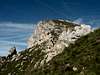
The summit of Pierre Avoi is a limestone tower of 170 m, good visible from the Rhone Valley.
The north west face provides a nice but difficult climb. The access is easy from Verbier and the cablecar of Savoleyres.
Nice view point over the Rhone Valley, the Grand Combin and the Mont Blanc.
The normal route is easy thanks to scales and steps cut into the stone slab during the 19th century.
In the south west, the nice Clochetons de Pierre Avoi are a pleasant climbing school with a lot of route of all difficulties.
Pierre Avoi comes from Pierre Avoua, petra acuta (latin) = sharp stone.
Webcam of Pierre Avoi
 |  |  |  |  |
Getting There
Start point : Verbier
To reach Verbier :
- Nearest airports : Sion, Geneva Cointrin
- Nearest stations : Le Châble, Martigny
- By the road :
Highway A9 to Martigny, E 27 to Sembrancher, turn left to Le Châble. From here turn left to Verbier
Distances :Martigny 27 km Lausanne 100 km Genève170 km Bern 160 km Milano 270 km Zurich 300 km München 520 km Frankfurt 540 km Paris 700 km Bruxelles 750 km Amsterdam 950 km
- By cable car : from Le Châble to Verbier
You can climb from Verbier or use the cable car of Savoleyres.
 |  |
Red Tape
No red tape
When To Climb
Pierre Avoi is a summer climb
 |
Mountain Conditions
Weather in Switzerland
Routes Overview
1) Normal route : South east face
- from Savoleyres
- from Verbier
2) North west face : TD climb (climbing sector D)
3) Clochetons (sectors A and B)
 |  |  |  |
The summit of Pierre Avoi
 |  |  |  |  |
Clochetons de Pierre Avoi
The Clochetons, the little bells of Pierre Avoi provide nice climbs on good equiped but short routes.
Infos :Olivier Roduit, mountain guide
 |  |  |  |  |
Climbing photos
 |  |  |  |  |
Camping
CHAMPSEC-LASASSE CAMPING SITE
(Verbier 20 min ) ++41 (0)27 778.13.23
FORÊT DES MELEZES CAMPING SITE (ASC*) BONATCHIESSE
(Verbier 30 min ) ++41 (0)27 778.12.40
CARAVANEIGE CAMPING SITE (Winter), LE CHÂBLE ++41 (0)27 776.20.51
The path of the senses
Access by the telecabins of Savoleyres/La Tzoumaz
This path enables an appreciation of nature by the use of our senses (smell, touch, and hearing). It has been developed in conjunction with the school for children handicapped by short-sightedness in Lausanne and aims to provide a bridge of communication between the blind, the semi-blind and those with normal sight.
At a height of 1700 metres the path starts at the Forest House (open mid-June until end of September).
In a first chalet is to be found a "Museum of the Senses" with the flora and fauna of the region. A second chalet displays plants with medicinal uses.
From the Forest House the path rejoins the Bisse de Saxon. It runs alongside the forest and comes out into the fields. A last bend winds through subalpine forest and more fields and rejoins the bed of the Fares.
Over the distance of 2.7 km of the walk, the rambler is invited to participate in one game and questions at 12 stations. Everyone is asked to describe the impressions and sensations aroused in him by the flora, the forest, the earth, the water and the birds which are met with.