

|
|
Mountain/Rock |
|---|---|
|
|
35.55720°N / 89.57700°E |
|
|
Mountaineering |
|
|
20685 ft / 6305 m |
|
|
Overview
 Early morning, very cold
The mountain was probably first seen by a westerner in 1896.
Sven Hedin, the Swedish cartographer, explorer, adventurer and map maker was on a quest of crossing the northern uninhabited part of Tibet, (the Chang Tang) but had to give up the project due to many deaths of support animals and starvation.
He was struck by the peak's beauty and wanted to give it a special name. As part of his expedition was sponsored by the King of Sweden - King Oskar II and because he saw himself as a royal supporter he baptized the peak Konung Oscars II Fjäll (King Oscar's Peak). The name is still to be found on older maps, even if the official name nowadays is Kangzhagri. To be 100% correct the name should probably be Kangzhag Ri, but usually the name is spelled in on word.
The Chang Tang is one of the world's most barren and desolate parts of the world and very few people has seen the peak at all. There are hundreds of kilometres to the closest road and conditions on the high plateau is harsh to the extreme.
The mountain is officially located in the Kokoshili/Hoh Xil Shan, which in turn (arguably) is a sub range of the Kunlun Shan.
Climbing history
A Japanese expedition lead by famous mountaineer and explorer Shigeru Masuyama visited the mountain in the winter of 1998/1999. They managed to make a first ascent of Kangzhagri East, but failed to climb the main summit because of the fierce cold.In 2003 Nadios and got close to the peak. After 25 days in the wilderness we were 19km from the foot of it, but decided not to attempt to climb it. Fatigued and with not enough food, we felt it had been an idiotic idea to give it a go.
Swedish adventurer Ola Skinnarmo organized an expedition to the peak in early 2007, but they failed to even get close to the mountain.
Kangzhagri finally got climbed by a two person party during the summer monsoon in 2007. It took them 27 days to reach the peak and it was climbed in alpine style.
Getting There & When To Climb
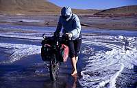 Crossing a frozen river
Many peaks has been dubbed to be the most difficult to reach, but I have to put my vote on Kangzhagri.
The way we choose, it was 420 kilometres through pure wilderness from where we left the road. You have to cross many high and steep passes, cross big rivers, deal with salt swamps and lots of mud. When on the actual plateau the altiude never drops below 4700 meters.
Simply put: just to reach the peak is an expedition in itself and you for sure put your life at risk making an attempt.
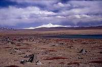 Kangzhagri seen from afar
From the north
Mangnai Zhen, a small mining town on the border between Xinjiang and Qinghai province is the closest settlement. You need an so called "Alien's Travel Permit" from the PSB (Public Security Bureau) in Golmud or Qiemo to even get into the last habited area. The reason for this is the extensive oil prospecting. Small truck paths leads you through the first ranges of 6000m peaks, but disappear gradually.
In order to get to the mountain, you basically need a GPS and a good map.
Which wild yak trail?
Take your pick. The direct line is not always the best and to avoid too steep passes or wild imposible-to-cross rivers, you have to choose your route with care. During the summer months the area is full of mud and I would say it's impossible to reach the mountain then. The spring is dangerous as you may get there, taking your changes driving on the frozen rivers, but you may get stuck out there when the melt off season starts.
The fall is unpredictable as flash floods and heavy precipitation can occur.
The winter months are frigidly cold. Temperatures down to -40C are to be reckoned with and a constant SSW of at least 20m/s is the norm.
 Negotiating mud fields
From the south
The last settement on the southern brink of the Chang Tang is a small village called Shuanghu (Twin Lakes).
There is a road that takes you 35 km north, but after that you have to do as on the northern approach - find your own way through the wilderness. A tip is to leave the road at Aru Lake/Tso and travel on the eastern side of it.
Huge river crossings south of Dogai Coring is one of the main obstacles and large fields of salty swamps further north makes the trip hard. The Dongbolhai mountain range has very steep passes.
If you have an interest in trying to reach the peak, please drop me a line and I can help you out with GPS coordinates and a more detailed description of the route.
Camping
 Camp close to Kangzhagri
As there are only 30 000 inhabitants living on the whole of the 600 000 km/2 (larger than France) Chang Tang plateau there are plenty of space. Pitch your tent anywhere. Be sure not to leave any food or even bags outside the tent. Ravens and Pikas will go for it at once. It may also attract bears and wolves, which are common in the area.
It's close to impossible to find any shelter from the ferocious wind and the ground is often very hard. A good option is to use a tent with so called storm-mats, so you can pin it down with sand, snow or mud.
Wildlife
The area around Kangzhagri and large parts of the Chang Tang has a unique wildlife.Wild yak, Kiyang (Tibetan wild donkey), Chiru (Tibetan antelope), wolf, bear, two different types of fox are common encounters.
Lynx, marmots, Tibetan gazelle, whooly hare, whistling hare and pole cats are not as common but the chances are quite high that you'll see them now and then if you spend some time on the plateau.
The most common mammal is the Pika, a little furry hole-digging creature which seems to be everywhere.
Most of the lakes en route has a high salt content and attracts sea birds. Cranes, goose, ducks, Himalayan snow cocks and of course gulls are common.
Lots of bird of pray inhabits the plateau.
Did we felt threatened by any animal up there?
Before the first encounter with a bear we were a bit worried about meeting one. One day we all of a sudden stood face to face with a large bear on approx. 40-50 meters distance.
I gripped my ice ax. The bear ran off in panic and it was a great feeling to to know that bears were much more scared of us, than the opposite.
The wolves were a little bit afraid, but most of the time they treated us with indifference.
The only time threatful situations occured was when a wild yak male wanted to show us who the boss was. He stood his ground and challenged us to come closer, blowing air hard through the nostrils.
We never accepted the challenge and found it better to make a large circle around the 1000kg heavy animal.
Red Tape
 Kangzhagri
The peak fee is $5000.
Arriving from the north or east national park fees has to be paid for Kokoshili NP and Altun Shan NP. In addition to that you also have to pay for The Chang Tang Natural Preserve fee. This is thousands of dollars per fee. On top of that you also have to pay for official guides, a liaison officer, transport etc. etc.
It's probably one the world's most expensive peaks when you've gotten the total sum of an expedition to the peak.
For ex. not even the travel to Shuanghu can be done without a steep fee. The cost for this according to the police boss in Shuanghu is $2300 (incl. the permit to visit Shuanghu).
As usual, the CTMA (Chinese Tibetan Mountaineering Association) are hard to deal with and they will not sell the peak cheap. They are the only ones which officially can sell you a permit though. Cowboy agencies in Xinjiang (Kashgar) may tell you they have the right to do so, but it's all in the grey zone. The QMA (Qinghai Mountaineering Association) can sell you a permit to Kangzhagri's lower neighbor Kangzhagri East, but not for the main peak this page is about. The reason the QMA can do so is because Kangzhagri East is located in Qinghai, but Kangzhagri is firmly located on Tibetan soil and therefore they can't help you with official permits.
That said, it's not even sure you can get the permits at all regardless of the amount of money you offer the authorities.
A certain climber from the Tirol wanted to cross the Chang Tang, but never got the permits.
Quotes about the area
 Desolation
A couple of words from some of the few persons who have been on the Chang Tang Plateau.
There is another Tibet, much of it above fifteen thousand feet, with treeless steppes and windswept ranges where only nomadic pastoralists with their herds of yaks, sheep, and goats can exist, and where there are vast tracts so barren that even they cannot survive. This is the Chang Tang.
George Schaller, National Geographic Society, 1997
"It is probably the hardest area of the world to get to - Bill Tilman and I had hoped to get there but it is too far in"
Eric Shipton, about reaching the Arka Tag, one of Kunlun's sub-ranges.
I have climbed the highest mountains on earth, but the Chang Tang sucks me dry of all energy"
Rick Ridgeway, climber of K2, Everest etc. Comment about being on the Chang Tang Plataeu and crossing the Kunlun.
"When on the plateau, my only thought is; Away, away, away from the Chang Tang."
Sven Hedin, 1896.
The film about the expedition
We brought a small video camera and shot about 15 h during the travel before, on and after the plateau. We did not particulary like the result and almost forgot about the films. When we got to know a sub-contractor to National Geographic was interested, we first hesitated to hand over the films, as we were quite disappointed about the result. Finally, we sent them the films, they liked the footage and a film was made.It's shown on National Geographic's international core channel, world wide now and then.
Later on, if anyone is interested in a copy of the film, drop me a line.