
|
|
Mountain/Rock |
|---|---|
|
|
47.65130°N / 121.4801°W |
|
|
5706 ft / 1739 m |
|
|
Overview
"Canoe Peak" is an unofficial name for Pk 5706 1.2 miles south of Lennox Mountain on the west fringe of the Alpine Lakes Wilderness. The name Canoe is associated with nearby Lake Kanim since kanim is an Indian word for canoe.Though the mountain is lower than Lennox--the highest peak in the area--it is, however, rockier with narrower ridges. There are three ridges to speak of (West, Northeast, and South). The first of these provides the easiest ridge route to the summit.
I first climbed this peak with two friends back in 1999. We were heading for Lennox but ran out of time. We then did Pk 5706 as a consulation prize. At the time I wasn't really a peakbagger hence didn't even know it had a name or was significant enough to be called a "peak". Two people prior to us (not sure of the year) had left a small piece of paper in a film cannister. They didn't know if the peak had been climbed before (likely it had) so christened it with a toponym that was some combination of their last names.
It should be noted there is a Pt. 5743 shown on maps one mile south of Canoe (Pk 5706). 5743 is an error. The contours at that point indicate only 5,640+ ft.
 |  |  |
Getting There
There are at two ways to hike up this mountain: from the east and from the west. I've successfully summited from the west during a failed attempt of Lennox Mountain. Probably the easiest route is from the west.Route from the West
This climb is slightly shorter than that of the eastern one in terms of distance but feels longer due to the complexity of the route. It is also a shorter approach from Seattle than for the east route (by about 45 minutes). Moreover, it starts about 800 feet higher than the east route. If you were so inclined, you could combine this climb with that of Lennox Mountain, which is 1.2 miles to the north.Car approach
The beginning of this approach is at North Bend or Snoqualmie (a shortcut from the west you can look into if you have a map; I won't elaborate here). The approach from there can be tricky. You will be traveling through some private timber lands. There are some gates but these are generally open. A logging permit shack passed en route does not apply to those going up that way to climb.
For the North Bend start point, take Exit 31 off of I-90 and proceed to the traffic light on the main street (Twede's Cafe on the right). Go straight (north) through the intersection 3 blocks to the major corner where Hwy 202 goes left to Snoqualmie. Go right at this corner and continue 2 blocks to a T-junction. Go left. In 0.4 miles the road bends right. In 1.0 mile the road goes back left. The road continues north past the western base of Mt. Si and crosses the Middle and North forks of the Snoqualmie River. In 2.4 miles (from where you left Hwy 202) the road goes past a junction on the left. Stay straight. The road bends to the right and goes to Ernies Grove (4 miles) where there is a fork. Go left. Wind your way up the hill beyond Ernies Grove then eventually go north for a ways. This is FR-57. In ~8 miles reach a major 4-way junction. Fuller Mountain (1,880 ft) will be off to the NNW. The logging permit shack is at this junction I believe. This is mentioned as Spur-10 Gate in Beckey's Cascade Alpine Guide.
Now you used to be able to take two continuances from here but I think the right one (right at the 4-way) is now gated. Instead, you have to go straight.
In 6.5 miles from the 4-way junction (~14.5 miles from North Bend) the road crosses over the North Fork Snoqualmie at Wagner Bridge. From Wagner Bridge continue up-valley for 5.5 miles to where the road turns left (1,585 ft) and crosses Lennox Creek. On the other (north) side of the creek a road almost immediately junctions off on the right. This is Lennox Creek Road. Take it. Drive 3.2 miles more (~23 miles from North Bend) to the Bare Mountain Trailhead (2,120 ft).
The hike
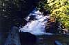
Note: The trail crosses Bear Creek in about 0.5 miles. This crossing, which is right below a picturesque slabby watercourse, can be difficult--especially for dogs or those who can't jump large distances. There is no footbridge or there did not use to be. I will check on this. If there still isn't a bridge, there is a way to circumvent the problem: Instead of starting at the trailhead, you can continue (drive) down the road to its end at the damaged/closed bridge across Bear Creek. You can still cross the bridge on foot. Once on the other side, simply hike northeastward up through forest for 400 vertical feet until you arrive at the trail. Stay as close to the creek as possible.
The trail crosses into the Alpine Lakes Wilderness shortly after the creek. In about 2 miles from the car a trail junction is reached (c. 3,480 ft). The trail going back left up the hill is for Bare Mountain. The trail going straight (east) continues to mines at approximately 4,000 ft south of Bear Lakes. Take the trail to the east. It will end eventually (at the adits?) at which point simply hike upward through mostly alpine terrain, passing Bear Lakes (4,660 ft) on the west. Scramble up to the minor saddle north of the larger lake. This is the saddle between Pt. 5449 on the west and "Canoe Peak" (Pk 5706) on the east.
From the saddle (5,400 ft) simply follow Canoe's West Ridge to the summit. The trees along the ridge become tight monkey squeezes but the climbing is otherwise straightforward (Class 3 max). A steep descent down treed gullies on the southwest side of the peak can be made to avoid the chapparals on the ridge. Beware of steep, slippery duff, though. These gullies could also be used for an ascent..
Total distance from the car = 3 miles. Gain = 3,600 ft. Time = 3-4 hours.
 |  |  |  |  |
Route from the East
This is a good spring snowshoe route. There is some overgrown road walking to a basin then minor cliffs (Class 3?) around the basin to climb through. The upper slopes are then east until the final ridge to the summit. If you were so inclined, you could combine this climb with that of Lennox Mountain, which is 1.2 miles to the north.Car approach
You need to take Miller River Road to the start point. Miller River Road junctions off of Stevens Pass Highway (US-2) between the towns of Baring and Skykomish--about 4.8 miles east of the former and 2.8 miles west of the latter. Look for the sign to Money Creek Campground, which is just across the river from the highway. The junction is just west of a highway tunnel. Alternately, if coming from the east, a 1-mile shortcut can be taken by crossing the river at Skykomish then proceeding along the road on the southside of the river.
Proceed past Money Creek Campground for about 0.9 miles to a junction on the right. In about 400 feet there is another fork. To the right is Money Creek Road (FR-6420). To the left is Miller River Road proper (FR-6410). Go left (straight). Pass Miller River Campground (1,020 ft) in 3.2 miles from the highway. In 4.5 miles (1,280 ft) an old road goes off on the right (goes up the West Fork Miller River valley). Park here as you cannot drive the road.
The hike
Hike the West Fork road SW for 2.6 miles to the Coney Creek crossing (2,040 ft). An old mine road (can be hard to find but is shown on maps) continues up the north side of Coney Creek for about half-a-mile. The old road makes two switchbacks in that half-mile. The road more or less becomes a trail, which itself ends in a basin at c. 2,700 ft about 3.7 miles from the car. Or, the trail may continue for about 0.6 miles to an old mine at 3,120 ft at the head of the basin. The idea is work one's way up through the cliffs (Class 3?) that head the basin to the gentler slopes above. Continue west to either the 5,040+ ft saddle or the ridgecrest immediately northeast of Canoe Peak's summit. Cross to the other side under the north side of the summit (North Fork Snoqualmie River drainage above Lake Kanim) in order to gain the West Ridge wherever feasible. Tight trees should be expected along the final ridge but the summit itself is open. If it looks possible, you could try and climb the NE Ridge (Class 3/4).
Total distance from the car = 5.5 miles. Gain = 4,400 ft. Time = 4-6 hours.
Red Tape
Lennox Mountain resides in the Alpine Lakes Wilderness. As such, standard wilderness policy applies (leave no trace, no motorized devices, no bolting routes, etc.). The east and northern approaches do not require a Trail Park Pass. I'm not sure on the west approach via the Bare Mountain Trail. Most likely, even if the last of these does, no ranger will be up that way to give tickets. They generally like to stay close to home or go to high-use trailheads to do that.When To Climb
It would be possible to backcountry ski or snowshoe Canoe Peak in winter. Access is the major issue. The start points (trailheads) are all under 2,200 ft. So if it's a dry winter these roads may be drivable. Also, avalanche considerations need to be made. Where as Lennox Mountain, by virtue of the security of the route to its summit, can be done in moderate avy conditions, Canoe Peak would be more suspect. The shortest routes to it cross more avalanche terrain--for both west and east routes.If skiing or snowshoeing is not your bag then the best time to climb would be June through the first autumn snows. Snow tends to linger until late June but in June this snow may be a benefit where it covers brush. May may be even better--especially for the route from the north.
 |  |
Camping
You should be able to climb Canoe in a day. If you would like to camp, though, Coney Lake east of Lennox Mountain would be an enjoyable spot. Lake Kanim might also work but it won't be as picturesque and it is kind of out of the way. Bear Lakes aren't very big or appealing but they are right underneath the SW side of the peak.Mountain Conditions
Localized forecastSeattle metropolitan forecast
Views from the Mountain
 |  |  |  |  |