
-
 8145 Hits
-
 84.27% Score
-
 18 Votes
|
|
Mountain/Rock |
|---|---|
|
|
46.69010°N / 12.44650°E |
|
|
8500 ft / 2591 m |
|
|
Overview
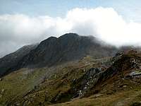
 Demut / La Mutta seen from Hochgräntenjoch Demut / La Mutta seen from Hochgräntenjoch |
The German name "Demut" in English means "humbleness" or "humility". It is a strange name for a mountain but somehow it seems to fit excellently. Demut (Italian: La Mutta) is located to the east of Hochgränten Pass in the Carnic Alps. This pass has been the scene of fierce fighting during World War I, when Italian Alpini and Austrian Kaiserjäger fought for every inch along the whole border between the two countries. Even today signs of that war still fill the area. There are trenches on both sides of the ridge - sometimes only 100m apart. There are the remains of the old positions - a collapsed wooden building here, a concrete one standing there and the odd cave furnished with shelves in between. It really starts you thinking about sense and nonsense of war in general and WW I in particular. So the name Demut seems oddly in place for a mountain towering above this area.
The positive aspect about the war - if there ever can be one - is that in order to provide the troops with supplies a lot of ascent trails have been built. Most of the Karnischer Höhenweg / Traversata Carnica trekking trail which follows the main ridge for 140km (90 miles) runs along these old supply paths on the Austrian side. In many cases the routes have been chosen ingeniously - there certainly is no better way to move around these summits. The ascent to Demut, for instance, leads along a ledge which has broken away in some parts. Here the pioneers user rail tracks, which they placed over the missing part with steel netting to provide sure footing. Needless to say that these WW I trails are maintained beautifully by the Alpine Clubs of Austria and Italy respectively.
 |  |  |
As for the summit itself it can be easily reached by one of the old war trails. It even is quite popular since it is the highest mountain in the neighbourhood of Hochgränten Pass. This (the pass) is rather popular because it hosts a beautiful heart shaped lake at the northern shore of which there is the highest war cemetery of the Alps. It is moving to see these eight graves of Austrian and Hungarian soldiers, which are draped by the tools they used. beside the shovel and the axe you will see the crude mountaineering equipment of their day.
 |  |  |
Demut is known for its fine views of the south-western Carnic Alps as well as the south-western parts of Hohe Tauern. It is the proximity to the Sexten Dolomites, however, that makes Demut real popular. You need a fine day, however, and as the Carnic Alps main ridge serves as a sort of weather divide you can easily be trapped in clouds.
Getting There
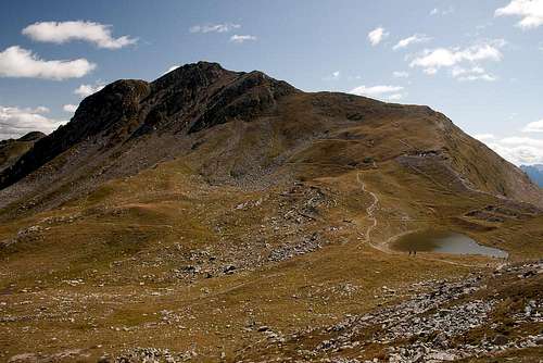 Hochgräntenjoch and Demut / La Mutta
The best starting point for an ascent of Demut is the village of Hollbruck south of the Tyrol Gailtal Valley. The village is a small, but touristy hamlet, which can be reached by a side road from Kartitsch. Another longish alternative is the Karnischer Höhenweg trekking trail, which starts in the west at Sexten / Sesto or Sillian.
From the West (Brenner Motorway A22)
Leave the Brenner Motorway near Brixen / Bressanone and follow SS49 to the east through Pustertal / Val Pusteria. To the east of Innichen / San Candido you cross the Austrian-Italian border and follow the road (now B100) to Tassenbach. Turn right (south-east) here onto B111, which you follow in direction Kartitsch. Shortly before you reach Kartitsch a side road turns off to the right, which will lead you to Hollbruck. Park your car in the village, where the ascent route starts.
From the North
There are two possible roads:
- From Kitzbühel over B108 through the Felbertauern Tunnel to Lienz, then southwest to Tassenbach (B100), where you turn on to B111 east into the Tyrol Gailtal.
- From Salzburg along motorway A10 to Spittal. Turn west on B100 to Oberdrauburg, there south to Kötschach-Mauthen were you turn east on B111. You need to go through the whole Lesachtal Valley to reach Kartitsch. Shortly afterwards turn to the left to Hollbruck
From the South (Udine)
Take Motorway A23 to the exit Camia Tolmezzo. Follow SS52 north to Tolmezzo where you turn onto SS52 bis. This leads to Plöckenpass, where it crosses the Austrian-Italian border. In Austria the road turns into B100 and at Kötschach-Mauthen you have to turn east on B111 into Lesachtal Valley. Again, go on through the whole valley to Kartitsch.
Red Tape
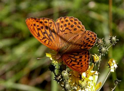 Argynnis (Argynnis) paphia
I'm not aware of any red tape here. The summit of Demut is located directly on the Austrian - Italian border so it is a good idea to have an ID at hand. Also camping in the area should not be considered for the same reasons. The nearest refuges are Sillianer Hütte to the west or Obstanser Seehütte to the east, both some two hours away.
When To Climb
 View of the Carnic Alps main ridge with Demut to the very right
The summit can be climbed all year round. The hiking season is May through October. Ski touring is possible in winter. The whole Carnic Alps main ridge is easily accessible from Sexten / Sesto and can be trversed by ski in its western part. The first serious difficulties will appear only at Porze / Cima Palombino, which is located quite centrally on the ridge.
Accommodation
As said above camping on the Austian - Italian border might not be the best idea. Near the refuges you shoudn't have problems but ask the proprietors.In most of the villages of Hochpustertal, Tyrol Gailtal and Lesachtal you can find small campgrounds, which are often associated with inns or hotels. If you are looking for hotel rooms or apartments follow one of the links below
Weather Conditions
Being the southernmost parts of Austria the states of Carinthia and East Tyrol show much better weather than the rest of the country. Still, the Carnic Alp Main Ridge is a main weather divide, so that rapid changes can occur. When we climbed Demut clouds kept rolling over the ridge and we only occasionally had the opportunity to see anything.You can keep yourself informed about the weather by one of the links below
- Tyrol weather
- Carinthia weather
- South Tyrol weather (for the english text you have to scroll down the right frame)
Maps & Books
MapsI have been using maps by Kompass Verlag, which are very good for the hiking trails though they don't show ALL the relevant summits of the area.
- Lienzer Dolomiten / Lesachtal
1:50000
Kompass Map WK47
Kompass Verlag
ISBN: 3-85491-053-3
- Gailtaler Alpen / Karnische Alpen / Oberdrautal
1:50000
Kompass Map WK60
Kompass Verlag
ISBN: 3-85491-067-3
As for books please look at the corresponding section of the Carnic Alps page.