
|
|
Mountain/Rock |
|---|---|
|
|
45.09750°N / 116.2014°W |
|
|
8479 ft / 2584 m |
|
|
Overview
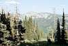
Granite Mountain rises approximately 4,660 feet above the extensive meadows of the meandering upper Little Salmon River and is the highest mountain visible on the east side of the valley from the town of New Meadows. However, only the west shoulder of the summit is seen from the valley. The mountain is most accessible from the east side on an easy three mile trail. Granite Mountain is on the New Meadows Ranger District of the Payette National Forest.The bulky summit is formed by two points connected by a long broad ridge. The flat western summit is very broad and supports a lookout. The east summit is a steeper pyramid and is one foot higher in elevation. The south side of the east pyramid is a steep walk, but the northwest and northeast faces are class 3 and 4 slopes respectively. Overall the south side of the mountain mostly gentle, but north side is much steeper, with some technical rock interspersed with steep scramble routes. Good primitive camping exists in the north basin where two small mountain lakes are found.
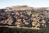
The mountain is formed mostly of granite of the Idaho Batholith and topped by open subalpine fir and whitebark pine forests. The loose rocky soils support spectacular wildflower gardens. The lower slopes are covered with Douglas fir, lodgepole pine, subalpine fir and spruce forests. The vicinity of the trailhead and much of the lower eastern side of the mountain burned extensively during the massive 1994 fires that charred nearly half a million acres on the Payette National Forest. Hiking through this blackened skeleton forest is a different experience. Unfortunately, you may be sharing the lower elevation areas with cows.
 |  |  |  |  |
Getting There
Turn north onto the Brundage Mountain Ski Area road (Forest Service Road 257) off of Highway 55. This is a left turn approximately 6 miles east of New Meadows or right approximately 4 miles west from McCall. Stay on this road approximately 10 miles to Goose Lake. Goose Lake is 2.2 miles long and Granite Mountain is on the other (west) side. Continue along side Goose Lake for approximately 1.5 mile and then take the left turn about 1 mile beyond the north end of the lake. It’s a very short drive to the Granite Mountain Trail 165 trailhead.The trailhead area is not clearly marked and some recent road obliteration work means what you find may not be exactly what you see on the map. Keep left and the road will loop around and want to return to the main road or turn left across the meadow to a herder’s cabin. Park wherever you like on the loop and then walk southward across the meadow towards the burned forest. There will be several cow trails formed in the area, but just stay on what appears to be the main trail. Very soon you will cross a creek and start a very gradual climb into the burned timber and you will realize you are on the right trail. The cows have formed a few spur trails here and there, but most seem to come back into the main trail. Watch out for cow pies.
The trail starts off very gradual, but soon will climb steadily up the east ridge before leveling off for a nice subalpine walk along the long summit area. The trail to Twin Lakes splits off to the right about 0.5 miles in. Twin Lakes is actually a single reservoir with two lobes and is the local hangout for several dozen cows.
 |  |  |  |  |
Red Tape
None. |  |
When To Climb
The best time to hike this mountain is from June until the late fall snows get deep (Oct or Nov).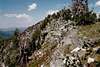 |  |
Camping
The nearest developed campground is Grouse Campground off the south end of Goose Lake. Hazard Lake Campground is on road 257, approximately 9 miles north of the Granite Mountain trailhead turnoff.Excellent dispersed campgrounds can be found along the east shore of Goose Lake. There is only a narrow space between the lake and the road, but still the setting is spectacular and this is the best camping near the trailhead. From the number of fishermen I saw, the lake must also support a good fishery.
Don’t bother camping in the meadow near the trailhead. This may look inviting, but there are too many wandering cows leaving their bombs lying around.
 |  |  |  |
Mountain Conditions
Current mountain conditions and access information can be obtained from the New Meadows Ranger District office of the Payette National Forest, (208) 347-0300.NOAA Forcast