
|
|
Mountain/Rock |
|---|---|
|
|
36.70770°N / 117.9621°W |
|
|
11102 ft / 3384 m |
|
|
Overview
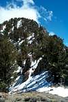
Keynot Peak stands among the Inyo Mountains as an attractive, symmetric "peak" in the truest sense of the word. Any climber driving through the Lone Pine vicinity immediately notices the stratified structure of its western profile and sinuous ridgelines defining its striking skyline.
Keynot stands just south of Mt Inyo, separated by a moderate col. Just to the south of Keynot lies New York Butte, yet another high point on the Sierra Clubs Desert Peaks List. Keynot Peak likely weighs in at about class 2 but our group managed to make it 3rd class via some dicey off-route meandering.
The following is copied from my Summitpost.com page on Mt Inyo, as they share the same approach and location characteristics:
"Mt Inyo is a somewhat indistinct highpoint in the Inyo Mountain Range, slightly overshadowed by its more distinctively pyramidal counterpart, Keynot Peak to the south. The peaks are located just south of the Inyo National Forest Boundary and as such, require nothing but time and effort to climb. They provide wonderful views of the Owens River Valley and once the col is reached, Saline Valley and the Cottonwood Mountains of Death Valley seem to be "just across the way."
The route up is steep and loose which makes for a grunt getting up but once you've bagged the summits (Inyo and Keynot) you can look forward to what has been called "the all-time scree descent of the universe." Approximately 4500 vertical ft of perfect scree sized rock patiently await entry into your boots. (hint - bring your gaiters.)
Many people do Inyo and/or Keynot as a dayhike; it can also be done as an overniter as great campsites exist at the Bedsprings Camp (7100ft.) Water can be found at this point in the form of snow depending on season but don't count on it being there." (end loose quote)
 |  |  |  |
Getting There
from the North end of Lone Pine, go north on 395 1/2 mile and head east on Lone Pine Narrow Gauge Rd (also abbreviated NPLG Rd on some of the signs.) Head east for approx 3 miles staying on the paved road until you get to a "Y" intersection where you will head north for 5 miles. At this point, look for a notch incut into the dirt berm on the east side of the road. Word has it that there used to be some tires piles up here to mark the correct turn. They were not in place when we did this trip. You should now be able to see the 4WD road heading up Union Wash; this is your objective. A 2WD vehicle will be able to get much of the way up; 4WD will get you another 1/2 mile or so depending on the current conditions and how badly you want to drive rather than walk.
Red Tape
Permits are not required.
There was a register box at the base of the south ridge of Union Wash but it had no register...
When To Climb
This peak can be done fairly comfortably in the spring and fall seasons
but the odd storm or heat spell can make things unpleasant - as with any peaks, be prepared for inclement weather. When we did this as a DPS trip in May of 2003 we had the spectrum of springtime weather on the ascent - drizzle, rain, snow, the usual.
Camping
Camping is allowed in the Union Wash area and on the route above.
Tuttle Creek BML campground, located just west of Lone Pine (and free) is a good spot and the standard staging area for many forays into the Whitney, Lone Pine and Inyo area.
Another car camp spot is the Boulder Creek RV Park; they have nice clean hot showers. $12/nite for car camp spot without hookups; more if you have an RV.
Mountain Conditions
Inyo National Forest District - Conditions
NOAA Weather for Lone Pine, California
The Weather Channel - Lone Pine, California
Useful Websites and Phone Numbers
Lone Pine InterAgency Visitor Center
760-876-6222
760-876-6223 TDD
P.O. Box R
Lone Pine, CA 93545
Junction of Hwy 395 & Hwy 136
Hours: 8:00 am to 4:50 pm
Open all year, 7 days a week
Inyo National Forest
351 Pacu Lane
Suite 200
Bishop, CA 93514
760-873-2400
TTY: 760-873-2538
External Links
- Mt Inyo
my SummitPost submission for nearby Mt Inyo