
|
|
Mountain/Rock |
|---|---|
|
|
42.76200°N / 0.5543°W |
|
|
7152 ft / 2180 m |
|
|
Overview
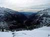
 A global sight of the peaks around Peña Blanca
Though not a specially spectacular summit, Peña Blanca offers a wonderful vantage point over the upper valley of Aragón. The whole valley can be seen from the summit after completing the 1000 meter climb, and climbers feel as if flying over the famous rail station of Canfranc. The massif of Collarada is right across the valley, and winter climbs (provided all necessary precautions are taken) allow visits to the nearby ice cave of Lecherines. A nice day out and a wonderful way to get training for higher enterprises...
 |  |  |
Getting There
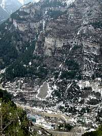

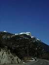
ROAD ACCESS: The climb begins from the village of Canfranc, in the valley of Aragón and about 14 km north from Jaca. The closest province capitals are Pamplona and Huesca. The trip from Pamplona should be done by road N240 (road signs "Huesca") until the small village of Puente la Reina. Right after crossing Puente, on the other side of the Aragón river turn left to follow the signs to Jaca. From the city of Huesca it's all the way along road N330, crossing the Monrepós mountain pass to reach the city of Sabiñánigo and turning left there to get to Jaca in twenty kilometers more. There will be only fourteen kilometers left to go north, and right after crossing the village of Villanúa and the road tunnel after it you shall be in sight of Canfranc. Do not get confused with the settlement known (and marked in the road signs) as "Canfranc Estación", for such is kind of the railroad station quarter of Canfranc. Your trailhead is Canfranc, plainly, the first village after Villanúa.
In order to get to Canfranc from France, start from the town of Oloron Ste-Marie and follow the road to the spanish border, south, all along the Vallée d'Aspe. You may cross the new road tunnel of Somport in order to get a shorter trip, but the old road across the mountain pass offers fine views of the Pyrenees. It's your choice!
NEAREST MAJOR AIRPORTS: Zaragoza / Barcelona (307 km)
RAILWAY ACCESS: The nearest rail station are the ones at Sabiñánigo and Jaca, thirty to fourty kilometers away from Astún. Additional transport will therefore be required. Check the link page ("Autobuses Valle del Aragón").
Red Tape
No special needs apart from those dictated by winter conditions. No problems for parking, for the village of Canfranc has some (small) free parking lots.When To Climb
The only real precaution to be taken is choosing as fine a weather as possible, mainly because of confort reasons. Winter climbs also make for a nice side trip to the nearby Ice Cave of Lecherines.Camping and huts
 Gabardito Hut
Camping is officially not allowed. At least not away from the official (and commercial) camping sites.
There are a couple of free (unguarded) huts on the normal route, one placed at the Majada de Gabardito and another one at the Majada de Lecherines ("Majada" is a local term for pastures). In the village of Canfranc there is a hostel (Refugio Sargantana - check links section) providing accomodation for reasonable prices and other hotel options are available in Canfranc Estación, Villanúa (Albergue Tritón - links page), Castiello de Jaca or Jaca itself.
The ice cave of Lecherines


It's just a small cavity placed southwest of Peña Blanca, but it can get extremely beautiful in winter time. Check the pictures if you don't believe me... Some mountain journals talked recently about a whole network of cavities to which the cave would be the entrance, but I haven't been able to confirm this up to this moment. I will keep you informed if something else arises...
External Links
- Canfranc village
Web page of the Canfranc Area. Includes webcam. - Refugio Sargantana
Spanish language info on this shelter in the village of Canfranc. As far as I've seen, no english version available. Sorry about that...
- Albergue Tritón - Villanúa
Spanish language info on the Tritón Hostel, placed scarcely four kilometers south of the Canfranc trailhead
Rafa Bartolome - Apr 12, 2005 6:22 am - Voted 10/10
Untitled CommentGPS coordinates of the summit of Pico de Peña Blanca: 42º44´42´´N, 0º32´10´´W.
The height: according with the map of M.Angulo of Canfranc and IGN is 2180 (my GPS indicate 2195m this year)
The seccondary summit of Peña Blanca (eastern) is 2055m (2059m in some map)