
-
 13893 Hits
-
 75.81% Score
-
 6 Votes
|
|
Mountain/Rock |
|---|---|
|
|
34.67020°N / 106.4293°W |
|
|
9313 ft / 2839 m |
|
|
Overview
One of a pair of peaks forming the southern border in a west-facing concavity in the middle of the Manzano Mountains, this peak and its twin resemble a lookout tower over the plain between the Rio Grande and the central mountain chain in New Mexico. Shorter than their southern neighbor, Manzano Peak, Osha Peak and the surrounding cluster of 9,000-footers attract little attention and make for a great day hike or overnight trip.
Getting There
Trigo Trailhead: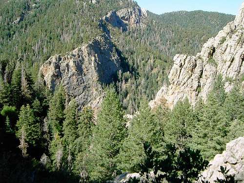
From Albuquerque, take I-25 south to exit 191. Go east on Camino del Llano/NM-548. At the first light turn left onto Main St./NM-314. After about a mile, take a right at a gas station onto Reinken Avenue/NM-309. On the east side of the river take a right onto NM-47 S/NM-6 S. Turn left on North Navajo road which is not marked, but is nearly two miles from the previous intersection. If you miss it, you can take South Navajo Road which is another 3.2 miles down the road and has a sign saying "forest access 19 miles". Either way, you end up taking the roads to a "T" intersection with Trigo Springs Rd. which has no markings. Drive north on Trigo Springs past a bunch of huge cows and bulls that you should avoid because of their aggressive behavior. After three or four watering holes in the middle of the road (you can avoid these with bypasses on the eastern side of the road), take a right onto another unmarked road that forks just before hitting Trigo Springs Rd. (when traveling west on it). This road is pretty rocky and slow-going all the way to the trailhead. It crosses the forest boundary at an unlocked green gate you can drive through. Take a left at the fork in the middle of John F. Kennedy campground and the trail begins at the brown gate.
Crest Trail:
Take I-40 out of Albuquerque. Get off on exit 175 and drive on to NM-337 south for 29 miles. Take a right onto NM-55 until Manzano. Go north/northwest on County Road B048 from Manzano and take a left onto County Road B067. This road changes into a forest road, but keep following it to the crest near Capilla Peak observatory. This route to the mountain also can deliver you to the eastside campgrounds that lie just off the road.
Along with the Capilla Peak USGS map (1/24 quad) at Topozone, some good maps are the Forest Service Manzano Mountain Wilderness Map, Cibola National Forest map, and the maps in the Coleman New Mexico Atlas and Gazetteer.
Red Tape

No permits or fees are required to hike or park at the trailhead. However, as always, follow the outdoors code of conduct and leave no trace. In addition, consideration should be given to the hawk watch area to the northeast of the peak, which indicates how important the region is to birds of prey. Osha Peak is in the Manzano Mountain Wilderness, which forbids use of motor vehicles and bikes on any of the trails.
When To Climb
The peak can be climbed at all times during the year, but the best times are from April until September like on most of the peaks in New Mexico. Afternoon thunderstorms also hound this mountain, more frequently during the spring, summer, and fall.
Due to the dry air, altitude, and intense sun that drain you of fluids, as well as the mostly dry streams in this region of the Manzano Mountains, it is important to pack plenty of water.
Camping
Camping is allowed without any fee. The only requirement is that you make no campfire. The three closest campgrounds are John F. Kennedy, Capilla Peak, and New Canyon. The JFK campground is on the westside of the Manzano Mtns. while the other two are on the eastside.Mountain Conditions
The only two websites you need are below with weather, fire danger, forest ranger contact information, and more.New Mexico Website
National Forest link