Overview
Redcliff, ranked
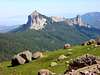
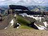
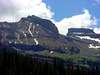
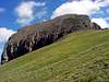
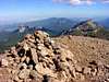
175th of Colorado's highest peaks, is one of the higher peaks in the Uncompahgre Wilderness and unlike it’s immediate neighbor to the south, Coxcomb Peak, is approachably via a non-technical route. The views of Coxcomb and Wetterhorn are amazing from Redcliff. Unfortunately the early start required to beat the summer storms means that the views of Uncompahgre are into the sun and not too photo worthy. Don’t worry, you won’t be disappointed. Solitude is available on Redcliff as my July 27 summit log register was only the 15th of the year. Saw no one on the entire route once leaving the trailhead.
Getting There
A Falcon Guide : Hiking Colorado’s Uncompahgre Wilderness provides excellent directions to find the trailhead. I highly recommend this book to anyone interested in the northern San Juans. The book provides two alternate directions but the following is the approach taken by me to the trailhead:
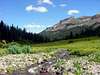
Turn east from U.S. Highway 550 onto Owl Creek Pass Road (Ouray County Road 10 – well signed) approximately 1.7 miles north of the intersection of U.S. Highway 550/State Highway 62 in Ridgway. Follow signs for just over 15 miles over Owl Creek Pass during which you will have great views of Courthouse Mountain and Chimney Rock.
Once over the pass you quickly come to an intersection. Take a right turn onto the West Fork Road. The road becomes more rough after about 2.5 miles where there is a parking lot for two-wheel drive vehicles. The last mile to the signed trailhead is passable to most high clearance, four-wheel drive vehicles. A high clearance, four-wheel drive vehicle will reduce the round trip route from about 8.5 miles to about 6.5 miles.
Red Tape
A majority of this route is located within the Uncompahgre Wilderness and typical wilderness rules apply. There are no permits required for the route.
When To Climb
The trailhead is most likely unreachable from much of the late fall, winter and spring months. The upper portion of the route is on very steep slopes that hold quite a bit of snow and would be very difficult away from the summer and early fall seasons. Ideal season is from July to September.
Camping
There are several dispersed (free!) camping spots along the West Fork Road prior to the trailhead.
Mountain Conditions
Check
local weather here.

 21016 Hits
 85.99% Score
 22 Votes