
-
 34499 Hits
-
 86.26% Score
-
 22 Votes
|
|
Mountain/Rock |
|---|---|
|
|
40.69800°N / 121.62°W |
|
|
8677 ft / 2645 m |
|
|
Overview
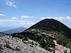
Crater Peak is located within the southern portion of the Cascade Mountain Range in the 16,335 acre Thousand Lakes Wilderness. Thousand Lakes Wilderness is midway between the town of Burney and Lassen Volcanic National Park.Crater Peak sits prominently between Mt. Shasta and Lassen Peak and is ranked at #49 in prominence for all California mountains. With 2,923 ft of prominence, Crater Peak can be seen from many miles away. Volcanic and glacial formations, rocky ravines, mountain slopes, open meadows, and stands of lodgepole pine and red fir define the Wilderness. It is dominated by 8,677 foot Crater Peak, the highest point on the Lassen National Forest, and is a reminder of the glacial action that eroded Thousand Lakes Volcano and created the many small lakes and ponds scattered throughout.
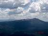
Nearby is Burney Mountain 7,863’ located to the north. Burney Mountain has an active manned fire lookout on its summit and there is a road to the summit. Burney Mountain is ranked #54 in prominence in California, so the side trip is well worth the time.
 |  |  |
Getting There
The Thousand Lakes Wilderness can be approached from 4 different directions. All approaches use either Hwy 299 or Hwy 89. These 2 highways cross each other near the town of Burney. There are trailheads on the north, south, east, and west and all can be used to access this small wilderness and summit Crater Peak. Three of the trailheads are accessed from Hwy 89. I chose to take the back door approach and accessed from Hwy 299 west of the town of Burney. The dirt forest service road listed as 4m001, 16, and 33N16 on the Lassen National Forest Map is located on the south side of Hwy 299 within 2 miles of Burney. There aren’t many options here, but bring a map of the Lassen National Forest. There are lots of unmapped branches off this road, but I just stayed on the main road and kept heading south until I got to the Magee turnoff.I drove south on this forest service road and took the side trip up Burney Mountain. It took about an hour to drive up and down Burney Mountain, but the views were worth it. Turn off the forest service road onto road 32N48 to the Magee Trailhead. This trail is no longer maintained and is not signed, but the road is good. Drive to the end of the road. The road has been extended to the Wilderness Boundary and there is a bare metal pole at the end of the road. The trail starts on the right side of the pole. There is parking for 3-4 cars at the trailhead.
The forest service roads are in good shape and there should be no problem getting to the trailhead in a 2WD vehicle in the summer time.
Red Tape
No permits are required. Maps and information are available at:Hat Creek Ranger District
43225 E. Hwy. 299
PO Box 220
Fall River Mills, CA 96028
(530) 336-5521
Or:
Red Tape Link
When To Climb
The summer use period is approximately June 15 to October 15, although early spring could open up the lower areas by Memorial Day. Your experience will be enhanced and impacts will lessened by avoiding weekends and holidays, and heavily used areas. Snowstorms can arrive unexpectedly, and hypothermia is a concern anytime of the year. Go toConditions Link
A critter worth mentioning is the mosquito. At times they are thick and hungry. It would be advisable to carry insect repellent in your pack.
Camping
This area is camping heaven! California Campfire permits are required beginning May 1st of each year until the officially declared end of fire season. Permits are required for charcoal fires, stoves and campfires outside of developed recreation areas (campground or picnic area).Permits are available free at any Forest Service, Bureau of Land Management or California Department of Forestry Office.
There are 7 campgrounds along Hwy 89 located along 10 miles of Hat Creek. The Lassen National Forest web site is very good and descriptive for all of their sites in this area.
Camping Link
Mountain Conditions
This is a summer hike, June through October. This is also a Wilderness Area, therefore, snowmobiles are not allowed in the winter. If you can get to the trailhead, you may be able to cross country ski into the area in the winter.Go to the following link for more information.
Conditions Link