
|
|
Mountain/Rock |
|---|---|
|
|
49.23161°N / 19.09947°E |
|
|
5282 ft / 1610 m |
|
|
Note
 Sunset on Rozsutec
The initial Rozsutec page was made by the user Hermi.
Following discussions about improving the content of some Carpathian-related "abandoned" pages, and thanks to the Elves, I was granted the editing rights on Rozsutec.
The page is currently under reconstuction. Given the importance of this peak, all suggestions are highly welcome !
Overview
 Panorama from the top
 Poludnové Skaly & Rozsutec
 From Stoh
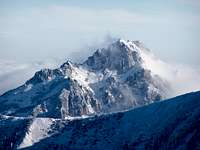 In winter
 From Boboty
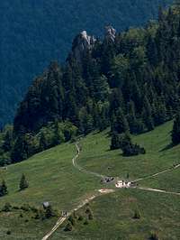
Veľký Rozsutec ("Big" rozsutec, to differenciate it from a smaller close brother), more commonly called Rozsutec or just "VR", is a highly emblematic mountain of the Slovak Carpathians, and often mentionned by the Slovaks as the "most beautiful mountain" of their country, out of the unreacheable Tatras.
Called "Wielki Rozsutiec" or "Rozsudziec" in the nearby Poland, the peak shares a common etymology with a certain "Rozsypaniec" in the Bieszczady, which tends to mean "scattered peak", and does make sense given its allure. It is called Nagy-Rozsutec in Hungarian and Große Rozsutec in German.
This peak, despite reaching a modest height, is absolutely beautiful, from all points of view, including also its historical background and legends associated to this place. The top is covered with one of the most precious and rare botanic ecosystem in Slovakia, protected by the status of the National Park.
 Rozsutec from Podžiar pass
 Dolomitic...
 Flowery
 Cloudy...
 Autumnal...
While most mountains of such nature and from the same area tend to show smooth round-shaped ranges, topped with forests disappearing timidly as we hit 1500, Veľký Rozsutec presents a surprising jagged dolomitic tooth full of cliffs and rocky features, best appreciated as we discover the mountain while arriving in Štefanová, or from neighbouring peaks like Stoh or Chleb. Not only the mountain is extremely rewarding to ascend, but it is also surrounded by a very interesting network of gorges dug by the water erosion: Horné Diery & Nové Diery. In short, Veľký Rozsutec is the perfect playground for those who seek the most entertaining possible hike. If you are with kids and if they are in good form, you can be pretty sure they will spend an unforgettable adventurous day.
Veľký Rozsutec lies on the northern side of the range of the Malá Fatra, almost forming the north end, and oriented NS, separating Nová Dolina (west) and Biela dolina (east). It can be recognized well in the skyline from Babia Góra, Pilsko, or Veľký Choč, to which it is often compared due to their similar craggy allure.
The top is visited by a red-marked hiking trail, equiped with fixed chains on the south side. Two important passes allow reaching this trail : Sedlo Medzirozsutce on the North (littelrally : "saddle between the Roszutec's", as it lies between Malý Rozsutec), and Sedlo Medziholie, which used to host the only mountain hut on the peak, Chata pod Rozsutcom, till it accidentally took fire on 17th January 1985. Currently, there is not any mountain hut on the mountain itself, and the nearest is Chata na Grúni, providing gorgeous views to Rozsutec.
 Poludnové Skaly & Rozsutec from the slope of Boboty
 From Medziholie
 From Tiesnavy
 From Malý Rozsutec
 On the rocks
Veľký Rozsutec is bordered by a smaller peak on its west flank, Poludnové Skaly. Seen from Štefanová, it seems almost equally high as Rozsutec itself, and suggest some twin peaks. There used to be a marked hiking trail, visible on former maps, making a loop around Poludnové Skaly and the rocks called "Skalné Mesto", but closed some time during the 80s, probably for bird nesting reasons (talking regulations on Rozsutec, read carefully the red tape). Despite closed, the route leading to the top of Rozsutec via Poludnové Skaly is also frequently mentionned, like for example this beautiful photo report blog.
On the north, but a bit further, is located the already mentionned Malý Rozsutec (1343m). Unlike its small size and friendly cylindric shape would suggest, it is the most difficult of the two. Its access from Sedlo Medzirozsutce is made via a very exposed rocky diagonal secured with a fixed chain. The access via the opposite side is made from Podrozsutec, a little but very pretty hamlet with old wooden houses. A not very commonly used route.
Talking folk mountain architecture, let's finish with few words about Štefanová, the village on the SW foot of Rozsutec, and most convenient base, with who all amators of traditional Carpathian wooden architecture will fall in love. Not to mention the beautiful views. This is not randomly that the producers of the 1963 version of Jánošík casted the place for the realisation of the film...
 Malý Rozsutec, Veľký Rozsutec and Stoh
Getting There
 From Velký Choč
 From Valaská Dubová
 From Veľká Fatra (?)
 From Babia Góra
 Štefanová from the top
The vilage Štefanová is the ideal trailhead, despite Terchová-Biely Potok, nearby, can also be used. Longer approaches allow also reaching the mountain South-East from the road 70 or 583, with a couple of trailheads near the towns Párnica and Biela. But all is located in a handkerchief and the general driving instructions do not vary much whatever is the trailhead.
However one must be aware the whole area is very hilly and wherever we come from, the drive gets more and more convoluted as we get nearer the place.
Terchová is the only convenient town, close enough to the mountain, to be served with bus and trains.
By car, it varies according to the place we come from.
From Slovakia and coming from Bratislava, most is done via the motorway D1 until Žilina, where we take the 583 road till Terchová. In Terchová, drive to the Vrátna Dolina (topped by an aluminum Jánošík statue), and then Štefanová left when inside the valley.
 Vrátna valley from the top of Rozsutec
 On the road
 Vrátna Dolina
 Štefanová view
 Štefanová
 From Sokolie
 From Terchová
 Early winter
 Deep winter
 Dolomitic
 M.R in Winter
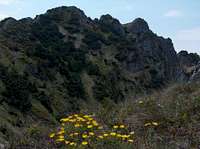 V.R from M.R
 V.R from M.R
Coming from Košice, the D1 via Poprad takes us to Ružomberok, and then it gets more complex. Take the road 18 Kraľovany, then 70 to Dolný Kubín, but turn before at Párnica via the 586 to Zázrivá and Terchová.
The vocation of the Slovak D1 motorway is to be fully continued in a medium-term future, and the planned route goes not far from Žilina, so it's likely that the acces to the Malá Fatra range will be much quicker.
The area is also close to Poland and several ways exist to reach it from this country. The luckiest ones are those who live in the Silesian region: despite often packed with cars, the drive through Bielsko-Biała, Żywiec and the border in Zwardoń is all straight. The 520 road is then reached either via Čadca or Oščadnica (smaller road). In Stará Bystrica, we take the tiny road which goes through Radôstka and Lutiše, passing a sceneric high pass before going down to the road 583 to Terchová.
We will meet important ongoing road works all along the Żywiec-Čadca area. The axis is meant to become a major road linking Poland and Slovakia, and the hilly region require a lot of equipments such as bridges and tunnels.
Those coming from Western Poland reach Čadca better by taking a short portion of Czech Republic in Těšín(Cieszyn), reached by leaving the A4 from Gliwice.
From Cracow and more East, we use the Zakopianka road that we follow until the Chyżne border. The road 59 leading SW, despite full of bends, takes us straight to Párnica, and then Terchová.
View Larger Map
 Sunset under Rozsutec Sunset under Rozsutec |
Routes
 Assault from the south of Rozsutec
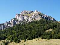 South side
 Chains on the south side
 From Stoh
 Malý Rozsutec
As the frame below shows, many ways lead to Rozsutec and many loops are possible to visit it. We'll try to summarize the most commonly done loops:
- Classic Loop from Štefanová
Take the green trail leaving East to Sedlo Medziholie. An increasingly steep scree slope, marked in red, leads north to Rozsutec, with a couple of exposed place secured with chains in the end.
The descent is made north to Sedlo Medzirozsutce. The trail of Horné Diery, with scales and ladders takes us back to the pass Požiar and the village.
However, few extras can be added, like combining Nové Diery to Horné Diery, and climb Malý Rozsutec way and back via the secured scramble. Those who have fears of the ladders in Horné Diery can avoid most of them taking the yellow and green trails from "Pod Palenicou" to "Huty".
Those who sleep in Chata na Grúni can undertake the long and ambitious hike that combines the summit of Stoh.
 Exposed and secured passage under the top
 Malý Rozsutec from Podrozsutec
 Pine-Bush wacking
 Malý Rozsutec from Veľký
 From Sedlo Medziholie
- Loop from Terchová (Biely Potok)
This trailhead takes us suddenly, via a very narrow gate, into Nové Diery, which ends in the Požiar pass. The shape of the loop is identical as previously described, except that we can mention the interesting possibility to descend Malý Rozsutec via the north side and the podrozsutec hamlet, green trail.
- Loops from the East
These circuits are less frequently done, but may be interesting for those who don't visit the mountain for the first time and keen for a change. The most practical trailhead is Biela, reached from Zázrivá. From there, we can reach Sedlo Medziholie via the green trail, visit both Veľký and Malý Rozsutec, and descend via Sedlo Príslop nad Bielou. The return to Biela is made on unmarked trails, but this is an area with many farms served with tracks, then it should not be a problem. A couple of trails also go under Rozsutec (blue under Veľký Rozsutec, yellow on both), for smaller walks.
The same loop can be done from Petrová near Zázrivá, or more distantly from Párnica (blue), Pred Lucivnou (yellow) or Bystřička (green).
 Looking East from Malý Rozsutec
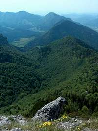 Vrátna from M.R Vrátna from M.R |
 Medzirozsutce from M.R Medzirozsutce from M.R |
 Medziholie from V.R Medziholie from V.R |
 Route to M.R Route to M.R |
 Malý Rozsutec Malý Rozsutec |
Red Tape
 Rupicolous
 Yellow vulneraria
 Blue gentian
 gentians with Mountain avens
Malá Fatra is a national park with similar regulations than in the Tatras, and even more strict concenrning winter closure.
* Walkig offtrails is forbidden
* Rockclimbing the walls of Rozsutec is forbidden (and dangerous too, considering the brittle nature of the rock)
* Wildcamping, bivouacking, fires strictly forbidden too. Consider also the high presence of bears. Having said that, there is a certain number of abandonned sherperd wooden huts known by locals, like this one, and using them overnight seems more or less tolerated, especially out of the high season.
* On the car parks of some trailheads, a little fee is collected (usually 1 or 2€)
* From November included to the 15th of June, all trails are closed in order for nature conservation, excepted for skitouring on the designated areas.
* From March do end of June included, the trail leading to the top of Veľký Rozsutec is closed, in order to protect the bird nestling.. A similar rule exists for the less known valley Obšívanka.
Which, unfortunately, leaves not much time during the year to climb Rozsutec...
 Over Štefanová
Accomodation
 Little pension in Štefanová
 Hut at Podžiar pass
 Terchová
 Chata na Grúni
 Štefanová
 Štefanová
* Wild camping & bivouacking : As mentionned in Red Tape, forbidden AND dangerous
* Official campsites: Two campsite near Terchová, convenient to explore Rozsutec : Autocamping Nižné Kamence, also called "Camp Terchová", and Autocamping Varín.
On former maps, a campsite is indicated near the central junction of the Vratna valley. But this campsite stopped in 2002.
* Mountain huts: Similarly, don't be mistaken by old maps showing Chata pod Rozsutcom south from Rozsutec, which disappeared in 1985. The nearest hut is Chata na Grúni, on a beautiful location, however significantly distant from Rozsutec.
* Private accomodations: One will find a handful of hotels, pensions and private apartments in Terchová. Most of them are registered on the accomodation section of the Terchová town page. However, as mentionned before, Štefanová is the most pleasant place. Accomodations there are less easy to find on the web since many of them are small, do not have any web page, reacheable only by phone and not speaking many foreign languages. Those looking for quality standard can try for example this one. Otherwise, if coming out of the high season, it is reasonably possible to pop into the village without any reservation, ask people randomly (very nice btw) and find the dream place immediately.
On the opposite side of the mountain, Biela (sometimes called Biela-Zázrivá to differenciate it from other Biela's) is also a charming place with few accomodations, like Chata Mária & Penzión Fatra.
 Štefanová
jck - Aug 29, 2005 11:58 am - Voted 10/10
Untitled CommentAnother trail leads from Sedlo Medziholie.The Sedlo(pass) is reachable from both sides(marked path from Stefanova).On Medziholie there was a hut but it was burnt down in January 1985.From the pass red marked path starts climbing toward the top. It's easy via ferrata but the trail is much more difficult than the route fom Medzirozsutce. So if you plan to traverse the summit it will be better to go up from Medziholie and descent via Medzirozsutce.
Nice idea is to go from Medziholie,climb Velky Rozsutec, descent to Medzirozsutce then climb Maly Rozsutec(1343 masl)-it's much more difficult than Velky Rozsutec and views from the top are much prettier.
jck - Aug 29, 2005 12:00 pm - Voted 10/10
Untitled CommentAll the informations about accomodation and festivals that take place in Terchova you may find there: http://www.terchova.sk/
jck - Aug 29, 2005 12:05 pm - Voted 10/10
Untitled Commenthttp://www.zsr.sk/cestpo.php
The time schedule of Slovakian Railways.
visentin - Jan 18, 2008 2:39 am - Voted 10/10
Rozsutec best mountain outside TatrasLet's mention that Rozsutec is for many people the best mountain of Slovakia and Poland together, outside the Tatras. http://h.visentin.free.fr/carpates/rozsutec.html A long but rewarding route can consist in climbing it from Stefanova from the South, then descending to the North (as described in my page), then climb Maly Rozsutec, and descend throug the gorges of Horné Diery till Podžiar. Then, it's possible to end the walk and come back to Stefanova, or continue with the exploration of Nové Diery. Boboty is also worth a half day hike in the same area.
visentin - Jan 18, 2008 2:44 am - Voted 10/10
Poludnové skalyDoes anyone know about the route named "Poludnové skaly" on this ancien map ? Looks like on new maps this trail has been closed : http://mapy.mk.cvut.cz/data/Slovensko-Slovakia/MF.Vratna.dolina.jpg
visentin - Oct 14, 2008 3:01 am - Voted 10/10
Horné Diery & Nové DieryHello ! I've made a canyon page for these 2 places. Perhaps you could report the informations connected to them from the Rozsutec page to it and put the names in links ? (I've given you edit rights on the Horné & Nové Diery page). Rozsutec is such a fine mountain with so many features that perhaps it deserves more space for itself only. (I can upload more Rozsutec pics if you want). My next projects are 2 more interesting canyons in Slovakia ! Cheers Eric