
|
|
Mountain/Rock |
|---|---|
|
|
43.75620°N / 114.1376°W |
|
|
11755 ft / 3583 m |
|
|
Duncans Peak Overview

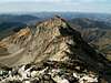
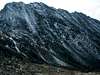
Duncan Peak, the highpoint of what the United States Geoloical Survey identifies as Duncan Ridge on local topographic maps, is an extremely rugged mountain charactierized by a 1.5 mile jagged ridgeline that dominates the skyline in the Hyndman Basin area.
The impressive Duncan Ridgeline, which runs from southwest to northeast, has two magnanimous faces that drop nearly vertical to the valleys below. Duncan Peak is Idaho 28th highest mountain and is named for Jonathan Duncan of Sun Valley, who passied in World War II.
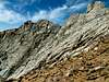
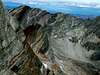
It is a likely scenario that many people attempt to climb Duncan Peak and Duncan Ridge, however, few end up reaching the true summit as it is difficult to tell where it is without a good map.
Duncan Peak, by any means, is an isolated peak, requiring a full day from any direction and a little bit of exposed scrambling to reach the summit. Fewer that 25 people had reached the top as of late 2005, but of those few, some one found it neccessary to leave a half burnt cigarette and a torn plastic sandwich bag in the cairn. Only the cigarette remains now.
 |  |  |  |  |
Getting There
To access the Wildhorse Ramp Route from Ketchum Idaho, drive south on Highway 75 seven miles and turn onto East Fork Road at the stoplight. To access from Hailey, Idaho, drive north on Highway 75 for seven miles and turn onto East Fork Road at the stoplight.
Continue on East Fork Road through the old mining town of Triumph until reaching a fork in the road, shortly after it turns gravel. Take the left fork and continue on this improved dirt road.
Pass the the impressive home on the hillside that is Pni Ranch, (these people graciously keep the road open, they have the option to close it), and drive two more miles to the trailhead. There are a few where the road is a bit rough but any passenger vehicle, including horse trailers can drive through to the end.
 |  |  |  |  |
Red Tape
Duncan Peak and Duncan Ridge are home to many mountain goat heards. It is unlawful and unkind to purposely seek them out.
No red tape or permits required.
The East Fork Road is closed to Pni Ranch in winter, or about 2 miles from the trailhead to the Wildhorse Ramp Route.
 |  |
When To Climb
Whether or not this mountain has snow or not would greatly affect the difficult of the routes to the summit. Duncan Peak is usually snow-free from early-August through mid-September.
Winter avalanches of the northwest and southeast faces are quite common and awe-inspiring to view from nearby Sun Valley.
Camping
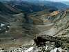
There are many wonderful camping spots around Duncan Peak. The large and grassy meadow below the summit and Hyndman Peak would be an excellent choice. And many spots along the approach trail, or at the trailhead would make fine camping areas.

Mountain Conditions
Duncans Peak is a remote mountain and conditions can vary considerably throughout the year. The following links provide the best info to be found on the area.
NOAA Pinpoint Forecast-Provides an excellent 7-day forecast for the area.

Sawtooth Avalanche Center- Gives daily avalanche reports during winter.