
|
|
Mountain/Rock |
|---|---|
|
|
16.0636°S / 71.2559°W |
|
|
15000 ft / 4572 m |
|
|
Overview
For those attempting to climb a 6000m peak near the city of Arequipa, this mountain provides a good dayhike and acclimatization. It is located about 1.5 to 2 hrs from Arequipa, "behind" el Misti and Chachani. The altitude was arrived at by GPS. We think it's real close. Most of the mountains in this region are unnamed and probably few except for the locals have ever been up them. There are many well-worn paths that seem to cross these mountains. Most of this land forms a national reserve, Parque Nacional Aguada Blanca and Parque Nacional Salinas.
This is the high desert. To the West lie Picchu Picchu, Misti and Chachani. To the North, the Colca Canyon and Ampato, to the South is Ubinas and the great Salt Lake. To the East, lie roads that will take you to Puno.
Many people spend time acclimatizing in Arequipa at around 8500 ft. But there are few options of walking or trekking in the area to an intermediate altitude. A trip to this vast area "behind" Misti leads to many possible options for just getting around, hiking, trekking, or even just driving at a higher altitude. The high point of the road we got to was around 13000 feet. Although there are no known designated "trails", it would seem that you could walk anywhere.
A word of caution. The limiting step is safety. There are many farmers who live in the area and keep llama and other animals on "their" land. (Keep in mind this is supposed to be a National Park). There are few roads that see occasional cars and there are many trucks. There are no police, except at the toll booth. There is nothing else and you are on your own. The locals may see you as intruding on "their" land although the roads and land generally are not owned by them. One scary story...when we went to hike here for a few hours one afternoon, we came upon a truck that had stopped close to our SUV. There were about 15 locals, including women and children that congregated around our SUV. It was a scary situation where we could have been robbed, had our car taken, or even been kidnapped. A small "donation" of money and food got them off our back. They are not used to seeing people back here and any foreign cars may be a threat to them. Years ago when terrorism was active in this area, you would never venture here at night because of the fear of kidnapping and robbery. It is supposedly safer now. My recommendation is to stay within site of your car, try to stay away from the locals, and stay away from the trafficked roads. If you can't do that, find a way to "hide" your car behind a hill or something to stay out of sight.
If you are looking for a good way to get up to 15000, there are many options in this area as there are many hills. Finding roads that take you there is the hard part. There are no signs and you can't really ask anyone. The main reason I put this page up is for caution and information regarding the area "behind" Misti and Chachani. Drive back to Arequipa and sleep at a lower elevation. You should be good to start any of the 6000 m peaks in the area, where base camp is generally between 14 and 16000 feet.
 |  |  |
Getting There
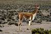
Take the road out of Arequipa past the airport. You will then get out of town and start climbing towards a cement factory in Yura. Keep going along this road and it will swing you around the North end of Chachani and eventually come around behind it. Eventually you will get to a toll booth and some large signs. To the left you go to Colca Canyon. To the right the road takes you toward Puno. Go to the right. You will see plenty of llama and vicuna. The road is good. At some point before the road starts climbing again to some small hills, there will be a green sign at a gentle left bend that says "Huaynacucho". There will also be a large gravel area and possibly a small hut. There are a couple dirt roads. Take the middle one and it will take you down and cross two dry river beds. Look to your right and you will see a rounded knob with a small tower at its base. There will be a pull off to the right where you can park your car.
Head toward the col between the tower and the mountain on easy sand and scree. Up there you will run into a trail which you can follow for part of the way. A side trip would be to go up the tower, which will get you above 14000 feet. Then follow pack animal tracks up the hill traversing to the highest point you can see. The general direction is always West. Once you reach the top, there are great views of Misti, Chachani and other peaks in the area.
 |  |  |  |  |
Red Tape
No red tape or permits. Just beware of the safety concerns with the locals as mentioned above. I would strongly urge you to go with someone that speaks Spanish, or better a local who can talk slang with anyone you run across.
When To Climb
Any time of year. The rainy season is Dec to March/April. This is high desert and can get cold at night, even in the summer.
Camping
I would not camp here.
Mountain Conditions
This is an easy walk up on an easy trail, albeit at altitude. Take water with you.
Corax - Nov 17, 2005 7:54 pm - Voted 10/10
Untitled CommentThanks for the response.
It's now much clearer why you wrote the section about caution as you did. Some other issues I didn't mention also got much clearer after reading it. Like, when you mention "terrorism", it was Guzmán and the rest of the SL bunch you had in mind.
Yes, the sixth sense is always very important to calibrate according to the environment you're in and I must admit I felt it should be on a quite high level when in many areas of Peru. Potential back street robberies and the "gringo syndrome" were the most common reasons.
Pre-Fujimori Peru was pretty hot in some spots. I remember the risk of being mugged back then was enormous. As you say and as I have interpreted what's going on in Peru now, the country is probably on the way to something better. I really hope so. This beautiful country deserves so much better than guerilla warfare and corrupt politicians.
Mike N - Nov 17, 2005 9:58 pm - Hasn't voted
Untitled CommentI have the feeling Peru will be unspoiled for some time. There aren't enough Peruvians ready to exploite all these climbing (also kayaking, trekking, surfing, etc) areas. The rest of the world seems to be interested in other places. Stay safe. Hope to see you out there some time.
Corax - Nov 16, 2005 9:25 pm - Voted 10/10
Untitled CommentI find your advice a little bit strange and I feel I must comment this.
I have been to the mentioned area and there's a lot of curious people around. They are mainly, as you say, farmers. A stranger is a big attraction for the people living out there and they come around to have a look at you and what you're doing.
I have never had any bad experiences and I wonder how you could interpret curiousity from women, children and farmers a possible robbing attempt? Have you ever heard about any kidnappings done by a group consisting of women and children? Was there any indication whatsoever anyone was going to steal your car?
What was so scary with the situation?
I strongly disagree with following:
A small "donation" of money and food got them off our back
Handing out money willy-nilly paves the road fine for the next person coming along that trail. This is why some trails, treks and climbs are nightmares nowadays, locals following you for hours asking for gifts. If they don't get what they want, agressiveness sometimes follows.
My recommendation is to stay within site of your car, try to stay away from the locals, and stay away from the trafficked roads.
Stay away from the locals?
How fun is that and how feasible is it?
How do you climb a mountain, when you at the same time have to stay close to your car?
Mike N - Nov 17, 2005 9:35 am - Hasn't voted
Untitled CommentCorax
Appreciate the comments. Maybe I have a different perspective. I am glad you know the area. I am Peruvian and have lived in Peru much of my life. My family lives in Arequipa. Sometimes having a sixth sense about what is happening around you in this or any third world country is what keeps us safe. As beautiful as Peru is and as kind the people can be, do not be misled. The real world in Peru can be very different than our initial impression. At all times you should exercise caution. Remeber that most of the Sendero Luminoso are "just kind farmers" until you are at gun point. This area behind Misti and Chachani has been site to many kidnappings, assaults, car thefts, etc. During the height of terrorism in the area, they used to paint large boulders black and put them on these roads at night. When you smashed your car into the boulders, you would find yourself surrounded by these kind farmers.
I say we were surrounded by men, women, and children only to show the point that it can be a very unnerving situation because you wonder why they are harassing you in the first place. Believe me the 4 males that were "talking" with me assumed I was "gringo" and I was able to pick up on much of their wispering and body language. The report I gave was to show that this area can be used to acclimatize, but also caution should be used.
Staying within eyesight of your car, unfortunately, is safe advice I can give to those who don't know the area. This only holds true for the large desolate areas along these roads. The basecamps for all these volcanoes and climbs are perectly safe. I don't think leaving your car off the side of the road for a few hours is very smart. You have a decent chance of returning to a car without lights, mirrors, windows, or worse wheels. It happens all the time in the cities...that's why people park in garages or pay a kid to keep an "eye" on the car.
This is a beautiful undeveloped part of the world. In addition to appreciating this we must also exercise due caution and respect. We are the outsiders here and Peruvians don't always see trekkers and climbers as that interesting. Thankfully that has changed a lot in the last 20 years. There used to be a time when riding your bike on the roads or running through some of these neighborhoods or leaving your car abandoned was suicidal. I believe it is better than it has been in the past, but it is not the US or Europe down there and we should be aware of that.
Corax - Nov 17, 2005 7:54 pm - Voted 10/10
Untitled CommentThanks for the response.
It's now much clearer why you wrote the section about caution as you did. Some other issues I didn't mention also got much clearer after reading it. Like, when you mention "terrorism", it was Guzmán and the rest of the SL bunch you had in mind.
Yes, the sixth sense is always very important to calibrate according to the environment you're in and I must admit I felt it should be on a quite high level when in many areas of Peru. Potential back street robberies and the "gringo syndrome" were the most common reasons.
Pre-Fujimori Peru was pretty hot in some spots. I remember the risk of being mugged back then was enormous. As you say and as I have interpreted what's going on in Peru now, the country is probably on the way to something better. I really hope so. This beautiful country deserves so much better than guerilla warfare and corrupt politicians.
Mike N - Nov 17, 2005 9:58 pm - Hasn't voted
Untitled CommentI have the feeling Peru will be unspoiled for some time. There aren't enough Peruvians ready to exploite all these climbing (also kayaking, trekking, surfing, etc) areas. The rest of the world seems to be interested in other places. Stay safe. Hope to see you out there some time.