
|
|
Mountain/Rock |
|---|---|
|
|
44.6926°S / 169.04630°E |
|
|
Hiking |
|
|
5177 ft / 1578 m |
|
|
Overview
The 1578m high Roys Peak is situated at the pleasantly blue lake Wanaka, in the Otago province of New Zealand. The climb itself is not much more than a strenuous hike, covering 1300m of altitude difference, but the views from the top are highly rewarding. From the summit you are overlooking New Zealands famous tussock-covered mountains, the beautiful lake Wanaka with several islands and bays, and to top it all off you have a nice view of Mount Aspiring and the surrounding national park. The peak is also popular with paragliders, on a sunny day you'll see plenty of them. The name of the peak probably comes from the Scottish Highland hero Rob Roy, there are multiple other things in the region named after him and the Otago province has a strong Scottish heritage.
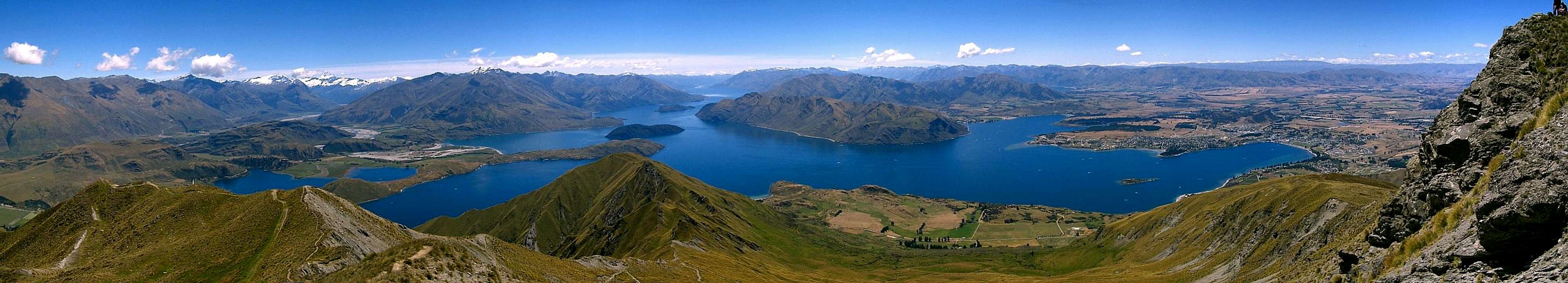
Panorama from the summit of Roys Peak. The track goes down the ridge, then to the right side of the mountain, all the way down to the parking lot (with the trees, 1300m below). On the right the town of Wanaka can be seen, in the left background the snowcapped mountains of Mt. Aspiring national park.
The track to the summit is very wide and easy, it winds its way through alpine meadows to the summit in about 2-3 hours. A large part of the track passes through private land, which is used to herd sheeps. Please respect the landowners property and leave all gates as you find them. On the lower slopes
you'll find a lot of thistles, thorn bushes and wild roses. Higher up the vegetation changes to tussock grasslands. All the way you'll find sheep, up to about 100m below the summit. Although the (very white) sheep make a nice decoration beware that you don't step in, or sit down on, sheep poo...!
For those seeking a bit more of challenge, Roys Peak can be linked together with neighboring Mount Alpha (1630m) via the Skyline Ridge traverse. This is a 9-10 hrs one way hike ending on a road 10 kms from Wanaka. Contact the local DOC visitor centre for more info on this track (see below).
 |
 |
Lake Wanaka
The beautifully blue lake Wanaka provides an excellent backdrop on your way up. This lake is carved out by huge glaciers, some 15.000 - 20.000 years ago, during the last ice age. The islands in the lake and the surrounding lower hills all have a distinctive round form, evidencing the glaciers grinding work. The lake is 45 km long, and up to 12 km wide. Due to many bays and islands the shoreline is 175 km long. The lake is 311m deep and lies at 277m above sea level, so the bottom of the lake is even below that. There are 5 significant islands in the lake, one of which even has its own lake near its summit. The lake is also the source of New Zealands largest river, the Clutha / Mata-Au.
 |
 |
 |
 |
Wanaka
The nearby town of Wanaka is buzzing with activity, as there are lots of things to do both in summer and winter. Typical for New Zealand, there are plenty of crazy kiwi activities: skydiving, scenic flights, skiing, heli-skiing, heli-mountain-biking, monster trucks, quad bikes, 4wd safaris, jetski, kite-surfing, ... etc.
The town has its own airport to accomodate all the aerial activities, also scenic flights to the famous Milford Sound depart from here. The town is packed over new year, and probably any other public holiday, so make sure you book your accomodation ahead if you wish to stay here during these periods.
Historically, the town was on a crossroad of three major Maori trading routes. Maori's travelling the (wet) west coast in search of greenstone, travelled to Wanaka to stock up on fish and birds. The settlements around the lake were usually just summer camps, although evidence has been found for more permanent settlement as well.
 |
Getting There
The nearest major town is Wanaka. From Wanaka the mountain is easy to find as you can already see it towering over the lake (click on thumbnail picture below for the view from Wanaka). Follow the road to Mt. Aspiring national park for about 6 km, and you'll see the parking lot for the trailhead on your left. The peak is also marked on the free maps with town info that you can get, although it may be marked as "Mt. Roy". This is confusing, as there is also a larger "Rob Roy Peak" or "Mt. Rob Roy" in the Aspiring National Park, but that one is higher and further away, so you should be able to tell the difference.
|
Red Tape
Part of the Roys Peak track crosses private land, which is used for herding sheep. No dogs are allowed. Please respect the landowners property, and leave all gates as you find them. The track is closed from October 1st to November 10th to allow for lambing.
 |
 |
Accomodation
Wanaka is a popular holiday destination and therefore has plenty of accomodation, including a campground. Camping on the mountain is not necessary as it is just a daytrip, and probably not permitted since most of it is private land.
Mountain Conditions
Average summer temperature for Wanaka is a cosy 23 C, in winter the highs are around 10 C. Wanaka is in the "rain-shadow" of the southern alps. Predominantly western winds blow in a lot of very wet air from the Tasman sea. This air then has to rise to get over the southern alps and loses all its water, resulting in a very, very wet west coast. In contrast, the lands behind the mountain range are pretty dry. Wanaka is also in these dry lands, although it is still pretty wet compared to other parts of central Otago.
The weather in New Zealand can change very rapidly. Always bring some extra warm clothing and some gear that will keep you dry. It is a good thing to check with the local D.O.C. visitors centre for the latest update on the weather. Especially if you're planning on doing the Skyline Ridge Track over Mt. Alpha, make sure that you're well informed on the weather, as this route is not as well marked as the Roys Peak track, and is prone to low cloud.
Good weather information can be found at:
- MetVUW.com - good weather forecast site, with satelite images, weather radar, charts, etc.
- D.O.C. visitor centre:
- Mt Aspiring National Park Visitor Centre
PO Box 93, Ardmore Street, Wanaka
ph (03) 443 7660
fax (03) 443 8777
e-mail: wanakavc@doc.govt.nz
The D.O.C. also has a daily weather forecast on the radio, at 8am
![]()
- Mt Aspiring National Park Visitor Centre
