|
|
Mountain/Rock |
|---|---|
|
|
45.85960°N / 7.67690°E |
|
|
9950 ft / 3033 m |
|
|
Overview
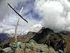
Becca di Trecarè, 3.033 mt. o.s.l., is a good idea to spend a full clear and sunny day, hiking on a easy peak with a tasty final. There aren't particularly difficulties. This hike is good for training for longer experiences (1 hour less then Grand Tournalin and Roisetta).The narrow and little summit, is a wonderful balcony on Mont Rosa group. Matterhorn is half hidden by Roisetta profile.
The top is easily reached via Col di Nana. The closer village is Cheneil, but even Chamois (Valtourneche valley) and Saint Jacques (Ayas valley) are possible startpoint. All three trails arrive at Col di Nana.
Becca di Trecarè is a funny ski-mountaineering hike (from Chamois or Cheneil), not so dangerous. Best period: february/april. As usual, it depends on snow conditions. The route is easy at Col di Nana (superb sightseen on Monte Rosa group), then a little bit more technical from Col di Nana to summit (last 15 minutes, only without skis).
 |  |  |  |  |
Getting to Cheneil
How to get to CHENEIL, Valtournenche.Coming from Switzerland: drive toward Aosta direction. Then follow A5 motorway, Turin/Milan direction. Get out from A5 at Chatillon/Saint Vincent.
Coming from France (Mont Blanc or Petit St. Bernard): drive toward Aosta direction. Once passed Aosta, forward to Chatillon/Saint Vincent exit.
Coming from Turin/Milan: drive on A5 motorway following Aosta direction. Get out from A5 at Chatillon/Saint Vincent.
Common route in Valtournenche. Once arrived in Chatillon, follow Cervinia direction, onto SR46 (Strada Regionale 46). Once arrived in Valtournenche village (Valtournenche is not only the name of the valley), before arriving at the Cable Way, turn right (there is a big panel with more than 20 villages names). The most visible panel is for "Hotel Tersiva". Drive to Cheneil direction (always "the main" road), until the road ends in a paved parking, free of charge.
There are two useful waypoint for your route GPS:
1) N45 52.876 E7 37.442 - right turn in Valtournenche for Cheneil
2) N45 52.035 E7 38.558 - car park in Cheneil. Cheneil is just 15 minutes walk, over the ugly parking.
All hikes in Cheneil begin at 2,023 mt o.s.l. (car park).
 |
Getting to Chamois
Chamois is a unique village in Val d'Aosta. Is reachable only through Cableway, from Buisson village, down in Valtournenche.Route indications are the same for Cheneil, but Buisson is, about 10 kms before arriving in Valtournenche (if my memory servers me well, there are 11 kms from Chatillon to Buisson), onto SR46.
Very popular prices for cableway to Chamois (1836 mt. o.s.l.)
Map section
IGC, foglio 108 (Cervino Matterhorn Breuil Cervinia Champoluc), scale 1:25.000 |
Hotels/Camping in Valtournenche
Hotel Panorama Bich, loc. Cheneil, 5, Valtournenche - 0039.0166.92019. Open in Spring and Summer. Call for a reservation! 20 beds.Other hotel: 91 hotels (* to *****) available in Valtournenche/Breuil Cervinia area. Locate your favourite with
www.paginegialle.it
Camping Glair - Località Glair, 6, Valtournenche - 0039.0166.92080.
Warning: free camping is allowed in Val d'Aosta, only over 2,500 mt o.s.l., from sunset to dawn.
 |  |
Talk about Becca Trecarè?