
|
|
Mountain/Rock |
|---|---|
|
|
38.79080°N / 113.6003°W |
|
|
Hiking |
|
|
Spring, Summer, Fall, Winter |
|
|
7108 ft / 2167 m |
|
|
Overview
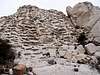
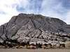
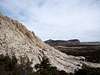
Crystal Peak is truly unique in its appearance and from the distance it’s clear what stands out on this peak. The peak is composed of white volcanic rock and contrasts sharply with the surrounding mountains; this is also how the peak got its name. Crystal Peak on the hike up
Crystal Peak is a distinctive feature at the northern end of the Wah Wah Mountains. The peak is visible from tens of miles away and as you drive closer to the peak you will see it is composed of numerous holes of all sizes where pumice once resided (see Geology section). The peak was formed some 34 million years ago and predates the Great Basin Desert and its topography.
Crystal Peak offers solitude, interesting geology and excellent desert views, especially of the bigger peaks in the Great Basin National Park. Hiking Crystal Peak is a short but fun and challenging scramble. With the exception of the route mentioned, all the other sides of this peak are much steeper and can be a dangerous hike because the white volcanic rock is brittle and breaks off very easily. The hike to the summit of Crystal Peak is relatively short, though nearby Fossil Mountain (45 minute drive) can be combined with this peak. Crystal Peak is also part of the North Wah Wah Mountains Wilderness.
 |  |  |  |  |
Geology
Crystal Peak shows evidence that there was volcanic activity in this part of the west, in fairly recent geologic history. The peak itself is believed to be a caldera or the middle of a large volcanic blast because of the peaks size. Embedded in the peak are many quartz crystals along with other rock types. Pumice which is magma that cooled extremely fast, can also be found embedded in the peak. The holes throughout the peak are where the pumice once resided. More information about the geology of this peak can be found here.Getting There
Some of these roads might not be labeled so use your odometer. All of the roads mentioned are either paved state highways or well graded dirt roads; a high clearance vehicle is not needed for any of these driving routes. Make sure you have plenty of gas as the closest gas station is in Baker, Nevada 40 miles away.
From Sale Lake City (213 miles) :
Head south on I-15 for approximately 65 miles to the town of Santaquin. Take State Highway 6 out of Santaquin west towards Delta. After 71 miles you reach Delta, continue heading west out of Delta. The road heads straight for 48 miles and then will bend in the mountains at Skull Rock Pass after the road bends, begin looking for a well graded dirt road to the left, approx 1 mile from the road bend. Take this road, Tule Valley Road and begin heading south to where the road ends at a T intersection after 20.5 miles. Go right at this intersection and head west, on Crystal Peak Road. Crystal Peak will be clearly visible from here. Drive 11 miles down Crystal Peak Road and the start of the hike will be staying east of Crystal Peak, but as close as you can get to the peak. Park here.
From Ely, Nevada (105 miles) :
Head east on State Highway 6 towards Utah, after entering Utah go exactly 16 miles and look for Ferguson Trail on the right, a well graded dirt road. Take this right and head south for 6 miles to a T intersection. At the T intersection, go left and you will be on Crystal Peak road. Follow Crystal Peak road which heads southeast then south and then east for 19.5 miles, Crystal Peak will be visible for most of this part of the drive. Continue past Crystal Peak to the east side of the peak this is where the hike begins. Park here.
From St. George (165 miles) :
Head north on I-15 to Cedar City to exit 62 and highway 130. Follow highway 130 north to 37 miles to Minersville where it intersection highway 21, take a left onto highway 21 and continue heading north 14 miles to Milford. In Milford take highway 257 north 24 miles to Black Rock, at Black Rock take a left onto Crystal Peak Road and head west for 35.5 miles to Crystal Peak, staying east of the peak. Park here.
The View
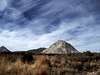
Although the view from the summit is partially blocked by larger mountains to the north and southwest, the remaining view is an extensive desert view. To the west several major mountains in Nevada can be seen. Wheel Peak and Jeff Davis Peak of Great Basin National Park can easily be seen about 40 miles away. To the northwest is Mount Moriah and in the distance North Schell Peak. Looking to the east is desert country and southeast is the 9,660 foot Frisco Peak.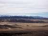 | 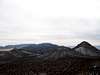 |  | 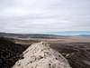 | 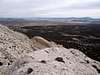 |
When To Climb
Fall, winter and spring are the best times to do this hike. The peak doesn’t get much precipitation therefore snow is rare in the winter. However, if there have been recent storms use caution when driving to and hiking this peak. During the summer expect hot weather and bring plenty of water.Red Tape & USGS Quads
No permits are required. Please follow wilderness area rules, as Crystal Peak is part of the North Wah Wah Mountains Wilderness.Camping
I would recommend camping right by Crystal Peak. Camping is allowed; there are several undeveloped camping spots right off Crystal Peak road. Around Crystal Peak are many junipers and sagebrush, so firewood is readily available. There are no permanent water sources around so bring plenty of water.The closest developed campgrounds are in the Great Basin National Park. There are several campgrounds to choose from. More information about these campgrounds can be found here.
Another nice camp spot is the Minersville Campground located in the Minersville State Park on the Minersville reservoir. This campground is 78 miles away and offers swimming, boating and fishing. To get there backtrack from the St. George driving route to Minersville and head east on highway 21 for 6 miles to the state park, more information.
To get to the Great Basin National Park from Crystal Peak :
Head west from Crystal Peak on Crystal Peak road for 33 miles to a T intersection with highway 159. Turn left onto highway 159 and head south for 1 mile to highway 487. Take a right onto highway 487 which heads towards Baker, Nevada. Go about 7.5 miles on highway 487 to highway 488 where there are signs for Great Basin National Park. Follow the signs to the park. There are several camping spots before this as well, after crossing into Nevada take your first left and head into the Great Basin National Park.