

|
|
Mountain/Rock |
|---|---|
|
|
46.95340°N / 9.81674°E |
|
|
Skiing |
|
|
Winter |
|
|
7224 ft / 2202 m |
|
|
Overview
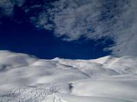
The Eggberg marks a highpoint in a mountainridge. It lies east of St. Antoenien in the Praettigau valley in Graubuenden, SE Switzerland.
Due to its location it it more protected from wind and avalanches than nearby mountains. These features makes it a popular skiing mountain even if the snow and weather conditions ar not favourable.
Because of all theses advantages, the Eggberg is a popular skiing mountain in this region. You can also approach it during summer on the same routes as in winter (easy hiking tour without climbing). But I would say it's more worthy to do it in winter.
Some people find the tour a little bit short for a full day. Well you can ski down from the summit to Alp Saess and go up to the summit again.
Orientation
On the summit we have a great fiew on the surrounding mountains.
In the N there is the huge Sulzfluh, in the NE the Schijenfluh, in the SE the Hasenflueli (same ridge as Eggberg) and in the S the Jaegglisch Horn. To the W is the village of St. Antoenien.
Getting There

If you come from the National Highway A13, take exit Landquart, direction Klosters / Davos. Now you enter the Praettigau valley. Drive until the village of Kueblis. Just before entering the village, turn left and follow the sign St. Antoenien. A small road will lead you there. Make sure that you have either a 4WD or snowchains. The road, is often icy and/or full of snow.
You can also reach St. Antoenien by public transportation. A bus will depart form Kueblis directly to St. Antoenien. (for onnections check the timetables in the link section)
Once you reach St. Antoenien you have two starting points, wich also mark the trailhead for the two main routes.
Litzirueti Route (2 hours)
Drive the main road through St. Antoenien until you reach a junction and a small bridge. This is Litzirueti (1461m). There is car parking and also a bus station. The bus serves until here. Do not follow the road to the right since there are no parkings available further up the hill and primarely reserved for local farm traffic. Start the tour by following the road (it's most of the time snow covered so skiing is possible) or besides the road. It's likely that there are already some skitraks which follow besides the road. Along the road you enter the Gafia Valley which has on both sides wood. Once you have passed the woods turn SW and proceed to a hut called Alp Gafia (marked on the map as Saess at 1941m). It's the only hut on this side so you should not have a hard time to find it. From there you can already see the summit. Continue towards SW over a saddle until you reach the ridge. Turn NW, after 200 meters you are on the summit. The summit is marked by a small pole with a sign.
Descending is best done through the ascend route or via the Ascharina Route.
Ascharina Route (2 hours)
From the centre of St. Antoenien Platz, turn S and drive to an outter part called Ascharina. You will come to a bridge over a creek called Alpbach. This is the start of the tour. If in doubt about the location, ask some locals, they are very friendly and help you with directions if something is not clear. From Alpbach bridge (1444m)follow the river stream upwards SE. On the lefthand side you will encounter a huge stable called Vodersaess (1800m). Now turn NE and switchback up the steep hill until the summit ridge. Once there, turn NW and after 200 meters you reach the summit.
Descending is best done through the ascend route or via the Litzirueti Route.
Red Tape
GeneralNo permit required.
Parking
It is advisable to pay the parking fee at the central parking machine. The police controlls the parking twice a day, so you will get a ticket. Do not park your car on or besides the street. It blocks the way for farming trucks and probably blocks someones access.
Widlife Sanctuary
Do not ascend or descend trough the N side of Eggberg. It is a protected area for wildlife and should not be entered. Local forest wardens check the area frequently. If you get caught by the wardens or the police you are in trouble and have to pay a big fine. It is also not unheard of that fellow skiers call the police if they see somebody descending the route. Please stick to the two official routes.
Camping / Accomodation
CampingNot required nor whished.
Accomodation
There are a number of small hotels and hostels in St. Antoenien and Kueblis. They offer good value for the money and are cozy. Book in advance if you go in the peak season (February-March) especially on weekends.
For hotels check the links below.
External Links
St. Antoenien Tourism (only in German)Tourism
St. Antoenien Hotels (only in German click on "Tourismus" -> "Hotels")
Hotels
Kueblis Hotels (only in German, click on "Tourismus" -> "Hotels")
Hotels
Public Transportation (in English)
Transport
National Weather Service(in English)
Weather
National Avalanche Service(in English)
Avalanches
Swiss Tourism(in English)
mySwitzerland
Maps
Swiss Topographic Map 1:25'000Nr 1177 "Serneus"
Swiss Ski Touring Map 1:50'000
Nr 248 S "Praettigau"
Both of these maps are readily available in Kueblis at the trainstation newspaper store or in St. Antoenien at the newspaper store