
-
 64774 Hits
-
 84.08% Score
-
 18 Votes
|
|
Mountain/Rock |
|---|---|
|
|
49.67783°N / 125.43174°W |
|
|
Hiking, Skiing |
|
|
Spring, Summer, Fall, Winter |
|
|
6867 ft / 2093 m |
|
|
Overview
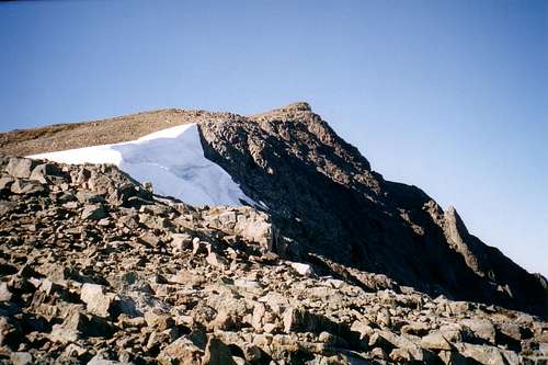
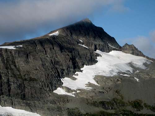 Mt Albert Edward Mt Albert Edward |
Mount Edward Albert is found in the eastern sector of Strathcona Provincial Park, Vancouver Island, British Columbia and at 2,093m ranks sixth in the altitude stakes on the Island. Unlike many peaks on the Island, the passage of the glaciers left at least the summit and northeast ridges of the mountain unscarred. The result is a relative rarity in Strathcona, an easy hiking peak. As if this wasn’t already an embarrassment of riches, a paved road climbs over a thousand metres from the coast and places the climber just 10 km of almost flat walking on an engineered trail from the start of the Class 2 route.
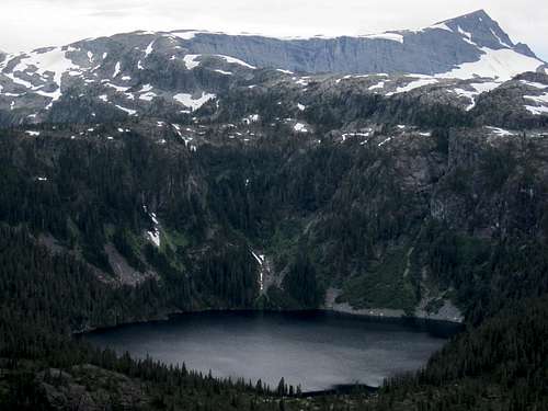
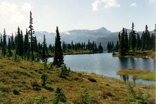
There is not one step of either the approach or the subsequent climb to the peak that isn’t stunningly lovely. From the pristine beauty of Paradise Meadows, to the somber atmosphere of Circlet Lake, to the magnificent forest on the ascent to the alpine, to the sudden jolt of the first view of the northeast cirque, this is a trip to savour for every moment you’re out there.
 Mt Albert Edward NE aspect, connecting ridge to Jutland Mountain and Circlet Lake from Strata Mountain. Photo by islandclimber Mt Albert Edward NE aspect, connecting ridge to Jutland Mountain and Circlet Lake from Strata Mountain. Photo by islandclimber |
Given all of the foregoing it will come as no surprise that this is an extremely popular trip. The ease of access, particularly to the camping areas at Kwai and Circlet Lakes, has unfortunately resulted in a lot of the sort of folk who think reality TV shows are about real life making this their adventure of a lifetime.
This is the place to see grandad’s old army frame pack (with machete and frying pan strapped to the outside of course) camouflage clothing, jeans etc. Such folk, however, don’t seem to be able to confine their sense of the inappropriate to just inadequate equipment. Dogs running wild, littering, late night partying and worse are to be expected. In fact Circlet is often referred to as “Circus Lake”. Government has stripped Parks' budget to the bone and they have neither the money nor the manpower to do anything about such awfulness. Avoid, or minimise, it by going midweek or in early (June) or late (October) season.
Albert Edward is also climbed frequently in winter and spring on snowshoes or skis.
It can also be tackled in a long day from cars without the need to camp. The round trip distance is approximately 35 km with a net ~1,000m elevation difference.
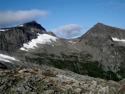
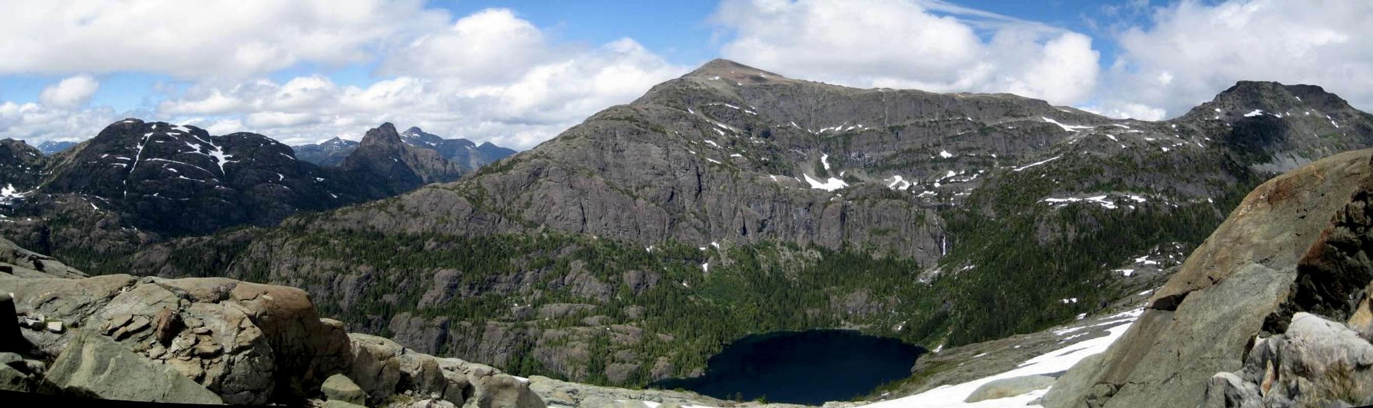
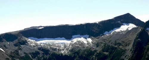 Mt Albert Edward NE Cirque. Panorama of the northeast cirque from Jutland Mountain. Mt Albert Edward NE Cirque. Panorama of the northeast cirque from Jutland Mountain. |
Getting There/Approach/Route
Vancouver Island can be reached by air from Vancouver to Victoria, Nanaimo or Campbell River and by ferry from Port Angeles to Victoria on The Coho and on BC Ferries from Vancouver to Victoria or Nanaimo. Public transport on the Island is relatively poor and anyone arriving by air would be advised to rent a car. Access in this case is all on paved roads and, therefore, fine with a normal sedan. Approach from north or south on the inland Island Highway 19. Near Courtenay take the Strathcona Parkway exit west to Mount Washington Alpine Resort (the reason for the paved road to 1000m). Drive up 20km and just before reaching the resort make a left turn onto Henry Road, following Parks signs for Paradise Meadows. Pass the bottom of the ski lifts after 1.5km and drive a further 0.5km to the end of the paved road at the cross-country facility Raven Lodge.Parks have established a new trailhead and information booth right beside the lodge. If you get back from your trip before 5.30 pm, the Raven Lodge has a lovely view over to the mountains and is a great place for the beer you so rightfully deserve!
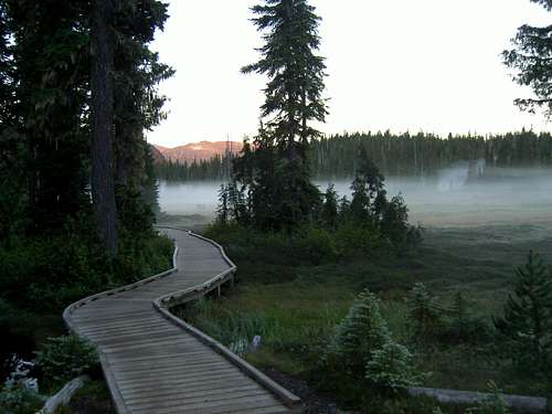 Paradise Meadows Paradise Meadows |
 Hairtrigger Lake Hairtrigger Lake |
 Mts Albert Edward & Regan from NE Ridge Mts Albert Edward & Regan from NE Ridge |
Five minutes up the trail watch for an old Comox and District Mountaineering Club (CDMC) wooden sign mounted high on a tree and indicating the way to Moat Lake. This is the beginning of a superb high circular route taking in the summits of Castlecrag, Mt Frink and connecting with the upper section of Albert Edward’s NE ridge. This is described in the Mt Frink posting. Carry straight on for Albert Edward. The route now steepens considerably as it winds its way up and to the right of a large bluff, crosses a rubble filled gully and ascends a final steep gully to a flat alpine plateau with numerous tarns underneath the NE ridge of Albert Edward. Cross the plateau and then go up one more steep bit before arriving on the ridge itself. This is a trail junction of sorts and is marked by a very large cairn. The trail by this point has become more of a booted-in route but it’s well marked with cairns and where you have to go is very obvious. At the large cairn you are presented with a stunning vista of the whole east facing shallow cirque below the upper part of Albert Edward’s NE ridge. To your right the ridge runs round north and west and up Jutland Mountain. On the same side of the drainage and connected to Albert Edward by a narrow ridge is Mt Regan.
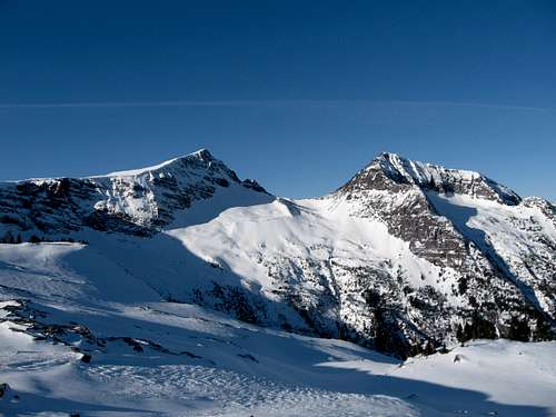 Mts Albert Edward & Regan from NE Ridge in winter Mts Albert Edward & Regan from NE Ridge in winter |
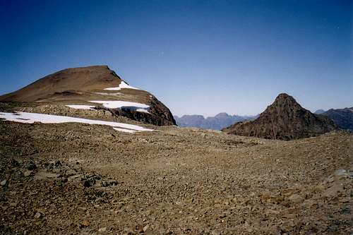 Upper NE Ridge and summit Upper NE Ridge and summit |
 Upper NE Ridge and summit from 500 m Upper NE Ridge and summit from 500 m |
Reverse the route back to camp or your car, watching carefully for the large cairn marking the point to drop off the NE ridge. There are also some arrows painted on rocks to aid in route finding at this point.
Red Tape
If you are a day-tripper, there is nothing to pay. If camping at Kwai or Circlet Lakes, or anywhere else in the designated core area of Strathcona Park, there is a $10/person/day fee. There is a self-registration box and payment slot at every core designated trailhead. Payment can be by cash or cheque. I haven’t seen a stipulation specifying Canadian funds but I’m sure Parks wouldn’t refuse a cheque in US funds.Camping

Camp at Circlet Lake
In this and all core areas of Strathcona Park you must camp only in the designated areas. In the present example this means at Kwai or Circlet Lakes. At each you will find a dozen or so wooden platforms. If none are available choose a site on the dirt that will cause as little impact as possible. Fires are strictly prohibited, so you must pack a stove. Both camping areas have a pit toilet and bear proof food cache. Giardia is well documented throughout Strathcona Park, so boil or treat all water.
Weather
Nearest point current conditions and forecast:AND/OR
You can get a live view of what the weather's doing right now at the Paradise Meadows trail head from Mt Washington's webcam
External Links/Additional Information/Suggested Reading
Strathcona Provincial ParkBeyond Nootka – A Historical Perspective of Vancouver Island Mountains, Lindsay Elms, Misthorn Press, 1996, ISBN 0-919537-29-4 and/or visit Beyond Nootka
Island Alpine – A Guide to The Mountains of Strathcona Park and Vancouver Island, Philip Stone, Wild Isle Publications, 2003, ISBN 0-9680766-5-3
  |