
-
 8947 Hits
-
 91.75% Score
-
 36 Votes
|
|
Mountain/Rock |
|---|---|
|
|
44.54890°N / 113.57°W |
|
|
Lemhi |
|
|
Hiking, Scrambling |
|
|
Summer, Fall |
|
|
10601 ft / 3231 m |
|
|
Overview
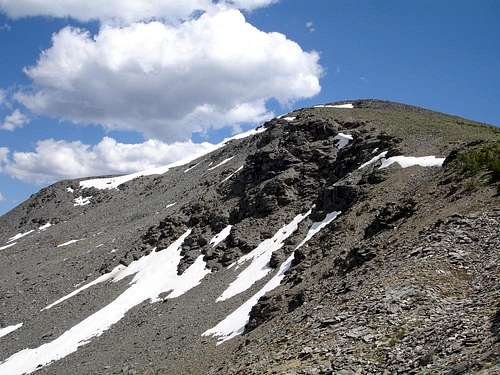
Big Eightmile Peak is located in the heart of eastern Idaho's remote Lemhi Range. The Lemhi's are one of the least visited mountain ranges in an already sparsely populated state. As a result, anyone headed to this region is pretty much guaranteed to find solitude. Big Eightmile is probably not a "destination peak" on its own, but is a great target to shoot for if you find yourself in the area. Other nearby points of interest include idyllic Devil's Basin and beautiful Yellow Lake. The summit of Big Eightmile Peak can easily be reached via Class 2 ridgelines when traveling between these two locations.Surrounded by many taller peaks and some of the more popular (relative term) hiking trails in the range, Big Eightmile Peak is an excellent vantage point to view the surrounding terrain. From the summit, you’ll find great views of the area and nearby Lemhi Peaks including 11ers Flatiron Mountain and Big Creek Peak as well as the attractive Yellow Peak and Gunsight Peak. You can also make out the Beaverhead Mountains in the distance to the northeast. But probably the most impressive view of all is an unobstructed line of sight to the southwest revealing the entire Lost River Range crest reaching from Mount Borah in the north, to USGS Peak in the south.
Big Eightmile Peak is the unofficial name given to this mountain because it stands prominently at the head of the valley that holds Big Eightmile Creek. From this valley the peak’s appearance is fairly impressive, but from other angles it is not particularly striking. From Devil's Basin to the west, the peak appears very tame with gently sloping ridgelines and lightly forested lower slopes. Or if you are familiar with the local lay of the land, you may be able to make out the tip of the peak in the distance from the trail that crosses the divide between Middle Fork Lake and Yellow Lake. In the end, the appearance of the peak probably doesn't draw many climbers, but those who reach the summit will be glad they made the effort.
 North Slopes
Getting There
 Yellow Lake Approach
Because of the remoteness of the Lemhi's, reaching a trailhead to access this peak generally involves a long drive. Both of the east side approaches listed below involve reaching the small town of Leadore (population 90) home to a gas station, small store, and a couple cafes. From Leadore, take the paved Lee Creek road heading west from the center of town.
For the west side approach to primitive Big Creek Campground, you must find your way to the small community of Howe then head north through the Little Lost River valley to the Pahsimeroi Valley, continuing until you reach the signed turnoff for Big Creek. This junction is about 50 miles north of Howe.
| Route | Description | Trailhead (Topozone Link) |
Mileage (One Way) |
Gain |
| NE Ridge via Yellow Lake | Probably the most scenic route you can use to reach the peak. The trail passes Middle Fork Lake and Yellow Lake en route to the saddle on the NE ridge. | M Fk Little Timber Cr | 6.5 | 2900' |
| NW Ridge via Devil's Basin | This is the most likely west side approach. It follows the North Fork of Big Creek to Devil's Basin, passing a few nice waterfalls along the way. Trail is easy to make out about 75% of the time. | Big Creek CG | 10.7 | 4000' |
| NE Ridge via Big Eightmile Cr | Follows Big Eightmile Creek through forest to some nice open meadows at the base of the peak. Climb to the saddle on the NE ridge from here on a sketchy trail. | Big Eightmile CG | 6.5 | 3200' |
| NW Ridge via Big Eightmile Cr | Could potentially use this as an alternate descent route back to the meadows at the base of the peak if you want to make a bit of a loop hike. | Big Eightmile CG | 7.6 | 3200' |
Camping
 Unmapped Lake
Camping is available at all three of the trailheads listed above. If you prefer to get a little closer to Big Eightmile Peak before setting up camp (which is recommended), great campsites can be found in Devil's Basin, the meadows at the head of Big Eightmile Creek, near Yellow Lake, or possibly at the secluded unmapped lake just east of the peak.
Red Tape
There is no red tape to worry about, just be responsible and tread lightly.When to Climb
Typical summer climbing season in the Lemhi's is from early July until the snow flies in October. The earlier you go, the more likely you are to encounter more difficult stream crossings, but the flows generally drop off by mid July.Mountain Conditions
- Leadore Ranger District - Contact Info for the nearest Forest Service Office.
- NOAA Pinpoint Forecast – Weather.
- Idaho Outdoors Forum – Message board monitored by many local climbers.
Guidebooks
Despite the remoteness of the area, there are actually a few guidebooks with details on this region. Here are a couple with useful information.- Idaho: A Climbing Guide by Tom Lopez – This is far and away the premier mountaineering text for the state, including details on Big Eightmile Peak and others in the vicinity.

- Trails of Eastern Idaho by Margaret Fuller and Jerry Painter – Lots of detailed route descriptions for the eastern part of the state, with information on trails in the area surrounding Big Eightmile Peak.
