
-
 34118 Hits
-
 83.32% Score
-
 17 Votes
|
|
Mountain/Rock |
|---|---|
|
|
45.47891°N / 112.96143°W |
|
|
Mountaineering |
|
|
11154 ft / 3400 m |
|
|
Overview
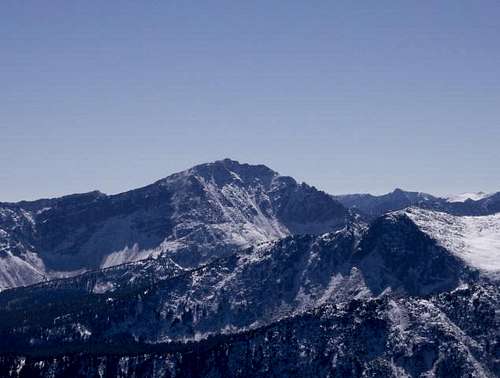
Tweedy Mountain is the highest point in Montana's Pioneer Range at 11,154 ft. Tweedy and Torrey Mountains dominate the view along Highway 15 north of Dillon. They also dominate all other mountains in the range by about 500-600 ft. Tweedy Mountain is also Beaverhead County's highest piont.
 Tweedy from the north on Granite Mountain
Getting There

Gerge Lakes from the top of Tweedy
Take I-90 to Hwy 15, which is several miles outside of Butte, MT, and then head south 40 miles to exit 74. If you are coming from the south just drive north out of Dillon to exit 74. From the exit you take the Apex road. Follow the Apex for about 4 miles into the Pioneer Range and turn right at Willow Creek road. The road will wind around a hill and start heading west by a lone house in the open. The road stays above Willow Creek for about 6 miles. The rest of the road is in pretty rough shape, so taking a vehicle with 4 wheel drive and good clearence is a good idea. There will be a road taking off to the left, side-hilling downhill(it doesn't go straight down like a couple of logging roads will.) This road will have a sign on it saying Gorge 1. The road will end after about a mile. Now you will be at the Gorge Lakes trailhead. From here you have two routes, each are about the same difficulty and length.

Barb Lake from the top of Tweedy

Tweedy from South Gorge Lake
Gorge Lakes Route:
Follow the trail to Gorge Lakes for about 2 1/2 to 3 miles. There will be a leaning tree and a couple of rock cairns offwhere the old trail takes from the new trail. Take the old trail on the left. It will take you to the south Gorge Lake and right below Tweedy after about a mile. The new trail takes you uphill a for about a mile and drops into the north Gorge Lake and from there you'd have to bushwhack south to the other Gorge Lake and to the base of Tweedy. Be aware that the old trail isn't maintained and can get hard to follow, but the route to the base of Tweedy is pretty obvious. From the north Gorge Lake you follow have to pick your route up. There is a scree slope leading to the top that you can take. It ends at a couple of chutes. These chutes are a difficult class 3 scramble for about 50 ft. Then you are on top.
The North-West Ridge can be climbed from Gorge Lakes also. This route is class 5+. From South Gorge lake, head to a notch in the knife ridge, on the Southwest end of the lake. From the notch it is a technical climb up the knife ridge that leads to the top. This approach should be done in June or July, while there is snow in the bowl below the ridge, otherwise the approach to the notch will be a miserable climb over loose, sandy scree.
Barb Lake Route:
You will need a topo map for this one, there is no trail to Barb Lake even though it is probably the prettiest lake in the Pioneer Range. From the Gorge Lakes trailhead you take off going south. Right away you have to cross a creek and climb a very steep north facing hill. After climbing the approximately 400 ft hill, you contour the side of Barb Ridge for about 4 miles and follow the drainage up to Barb Lake. Head to the North side of Barb Lake where a scree slope comes down. Follow the scree slope up a ways and then it will turn into a nice class 2 climb to the top of Tweedy.
Each route has its pros and cons, but each are trips through some beautiful country. There is also a route up the Northwest ridge from the West side. The route goes from Mono Creek Campground to Torrey Lake but the route is 8.5 miles long.
Camping
Barb Lake and Gorge Lakes offer some great spots for camping. Fishing is great there too. The east side of Barb Lake is a nice sandy beach.
Gorge Lakes have some spires to the west that offer some places to rock climb, but some of the rock is pretty rotten.
When to Climb
Barb Lake route can be done on foot or on skis.
The Gorge Lake route should probably be done during the summer or fall.