
|
|
Mountain/Rock |
|---|---|
|
|
38.52806°N / 78.44222°W |
|
|
Page |
|
|
Hiking |
|
|
Spring, Summer, Fall, Winter |
|
|
3721 ft / 1134 m |
|
|
Overview
Blackrock is a mountain summit west of Big Meadows in Shenandoah National Park. Big Meadows itself is a wide meadow east of Skyline Drive at an elevation of about 3500'.To the west of Skyline Drive, the area is developed, with a lodge, a restaurant, and a ranger station. There is also a picnic area and a camping area (albeit not a rustic one). Just above the lodge is Blackrock. The summit provides one of the best vantage points in the park, with the Shenandoah Valley to the west and views of the mountains to the North. On a clear day, you can see far into West Virginia from the summit.
Blackrock is often overshadowed by the development nearby depleting its rustic charm. It is also overshadowed by its neighbor, Hawksbill Mountain, the highest point in the park.
There are several ways to reach the summit. A few of them enable you to skip the development of the Big Meadows area, by taking the Appalachian Trail. All in all, this is a fine summit, with a solid 2 hour round-trip hike via the longer trails, an excellent view from the summit, and excellent views along the trails. On top of all that, you can enjoy the Big Meadows themselves on the other side of Skyline Drive.
Blackrock, which is in Page County, should not be confused with Blackrock further south in Rockingham County. Oddly, even though both mountains are located in Shenandoah National Park, they have the same name on topographic maps.
Getting There
From Washington DC follow I-66 West and exit onto US 29 at Gainesville. Follow to Warrenton, and take 211 West. Take 211 to Sperryville until you reach Skyline Drive. Take Skyline Drive south for about 20 miles to hit any of the various trailheads.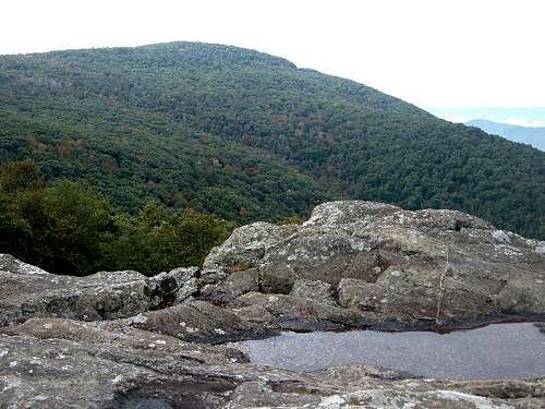
Blackrock just after the rain in late September 2006
Routes
Blackrock can be hiked via several different routes. While short routes are available inside the Big Meadows area, for those seeking longer routes via trails that run primarily through the woods, these are your best options.Fishers Gap (3070')
Drive south on Skyline Drive to milepost 49.4 and drive down a small road to a parking area. At the edge of the parking area hike down a small hill and get on the Appalachian Trail going Southbound. This is the most scenic hiking route because there are several nice overlooks from clifftops along the trail. You will pass developed sites in the Big Meadows recreational area as you hike. Once you pass the lodge on the left, you are almost there. You turn left at a marker just before a big downhill. The hike to the summit is about 2 1/4 miles.
Round Trip Hiking Mileage: ~4.5 miles
Elevation Gain: ~650 feet
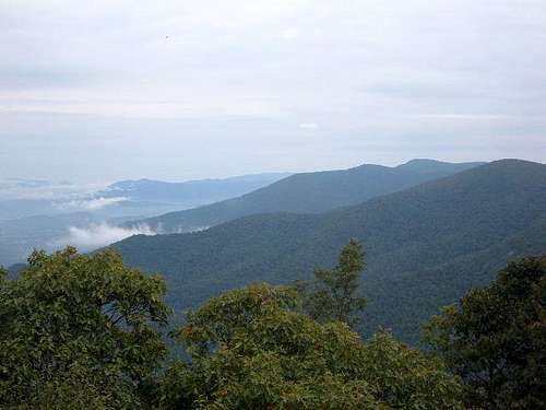
View from the Appalachian Trail coming from Fishers Gap.
Milam Gap (3230')
Drive south on Skyline Drive to milepost 52.8. Park at the large parking area and get on the Appalachian Trail Northbound. After about 25-40 minutes, you should cross a gravel road. From here, you have less than 1/2 mile to go before the right turnoff to the Blackrock summit.
Round Trip Hiking Mileage: ~4 miles
Elevation Gain: ~500 feet
Tanners Ridge Overlook (3465')
Drive south on Skyline Drive to milepost 51.5, just past the Big Meadows sign. There is a parking area that fits several cars on Skyline Drive. Walk up Skyline Drive northbound for about 50 yards. On the same side of the road as the parking lot is an access road blocked by a chain. This road turns into gravel before it reaches the Appalachian Trail. After 0.2 miles of hiking down the road you will hit the AT. Take a right, and follow the AT Northbound for less than a 1/2 mile to the turnoff on the right that leads to the summit of Blackrock. From the AT to the summit, the route climbs about 500 feet to the summit. On the way back you have to walk up about 250 feet to get back to Skyline Drive.
Round Trip Hiking Mileage: ~1 mile
Elevation Gain: ~750 feet
Red Tape
Shenandoah National Park cost $30 for an annual pass. If you do not live in the DC area, you can pay the $15 fee to enter Skyline Drive ($10 from December-February). For mountain conditions, check with the park at 540-999-3500. Press 4 and then 1 for current conditions and road closings.External Links
- Weather
Weather for the nearby town of Sperryville
- Shenandoah National Park
Shenandoah National Park Homepage
- Map of the Big Meadows Area
Full area map from the Shenandoah National Park Homepage