
|
|
Mountain/Rock |
|---|---|
|
|
47.68158°N / 13.21315°E |
|
|
Hallein / Tennengau |
|
|
Hiking, Scrambling, Canyoneering, Skiing |
|
|
Spring, Summer, Fall, Winter |
|
|
5407 ft / 1648 m |
|
|
Overview
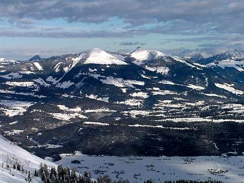 |
Schlenken is a very popular mountain east of the old mining town Hallein and only 15km south of the city of Salzburg.
Schlenken is located in the western part of the Osterhorn group, a subgroup to the Salzkammergut Mountains.
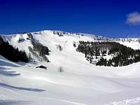
Schlenken is a characteristic mountain of the Osterhorn group with beautiful mountain pastures on gentle inclined slopes on one side and sharp ridges and steep and rocky slopes on the other side.
Deep canyons, such as Tauglklamm in the south and Almbachklamm in the north-west of Schlenken cut their way to the wide Salzach Valley.
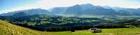
Schlenken is surrounded by lovely small villages as St. Koloman in the south, Kuchl in the south-west, Bad Vigaun (nice spa) in the west, Adnet which is famous for its red limestone (that has been mined since Roman times) in the north-west, Krispl in the north and Hintersee in the north-east. Due to the vicinity to the towns of Hallein and Salzburg, the good roads that lead to the mountain and the great views on the spectacular limestone Alps (Watzmann , Tennengebirge , Dachstein, Untersberg) and the flatlands in the north you usually won´t be alone on Schlenken. But still it is possible to find places where you can quietly enjoy this mountain.
|
|
|
|
|---|


Getting There
Schlenken is situated about 15km south of Salzburg City. Salzburg has an international airport and is connected to the transnational railway and motorway net.The villages around Schlenken can be reached by public transports like busses (St. Koloman, Adnet, Krispl, Hintersee) or by bus and train (Hallein, Vigaun, Kuchl).
An online train timetable can be found at: http://www.oebb.at/en/index.html
Roads shorten your ascent from Krispl and Rengerberg (via Vigaun).
Red Tape
There is no red tape. Keep the mountains clean.Camping and Accomodation
There are many possibilities to stay in the adjacent villages or nearby towns (from camping to 5 star hotels).There is one hut on the mountain:
Halleiner Hütte
Spumberg 55
A-5421 Adnet
Tel. 0043 (0) 6240-415
Other huts that offer food and drinks are:
Zillhütte
Tel. 0664/1029601
Trauttenstattalm with great views
Tel. 06245/74360
Tenneralm
Tel. 0664/990 97 56
 Vigaun Vigaun |  Hallein Hallein |  Kuchl Kuchl |
When to climb
Schlenken can be climbed all around the year. In winter and spring it is a favourite target for ski mountaineers. For hiking autumn is perfekt while in summer it can be unbearable hot. Mountain Pastures Mountain Pastures |  Skiing Skiing |  Summer Summer |  Autumn Autumn |
Geology
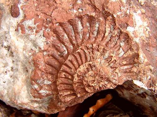
Schlenken is mainly composed of Upper Jurassic limestones (Oberalmer Kalke, Barmsteinkalke) which are underlain by radiolarites, red ammonite limestones of Lower Jurassic age (Adneter Kalke) and Upper Triassic marls and limestones (Kössen Formation). The massive Barmsteinkalke are the remnants of turbidity currents that rushed into deep sea basins forming now steep rock faces. Oberalmer limestones show karstification and many caves.
Caves
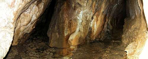
Till today dozens of caves have been explored. In contrast to huge and old cave systems of Tennengebirge the most important caves of Schlenken are relatively young and active water caves. Caving in this area is extremely demanding but can also be highly interesting and fun if you dont mind creeping through extremely narrow wet and loamy passages climbing over waterfalls or swimming through cold cave lakes (water temp. between 4 and 6°C ).
 Hennerloch Hennerloch | 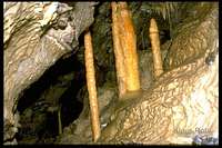 Lengfeldkeller Lengfeldkeller |  Eisenloch Eisenloch | 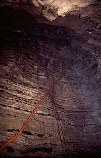 Theodom Theodom |
Maps
The best map covering Schlenken and surroundings is theAustrian Map 1:50.000 sheet N°94 Hallein
that also shows all marked trails
The Austrian Map can also be found on the internet at
http://www.amap.at