
|
|
Mountain/Rock |
|---|---|
|
|
43.38866°N / 110.54573°W |
|
|
Hiking, Skiing |
|
|
Spring, Summer, Fall |
|
|
11180 ft / 3408 m |
|
|
Overview

2/16/2015 -This page has graciously been given me by it's former owner, shalman, for which I'm very pleased. My aim isn't to gut this site altogether, but to integrate more material into the mix. This is a great peak that due to its character, beauty, and relative remoteness would probably be known in any range. The Gros Ventre Range contains what is in many ways the quintessential mountain wilderness area. Being between two great mountain ranges, the Tetons and the Wind Rivers, the Gros Ventres hide in plain site. One of the outstanding big game hunting localities on the continent is within this great range. Areas of real solitude abound and can be reached with not too much trouble. A place worth exploring. Peace, Dana
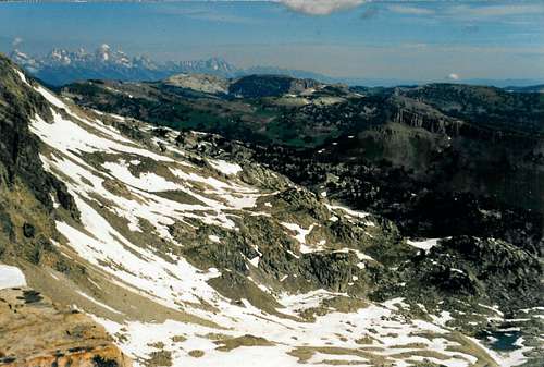
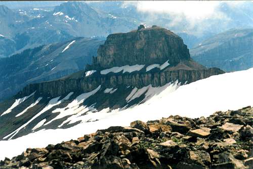
Indeed, this mountain is the dominant feature of the long line of summits stretching from Terrace Peak to Cache Peak. Its sprawling northwest and southeast ridges give Gros Peak both bulk and symmetry. Standing alone, the nearest higher neighbors are Sheep Mountain (a.k.a. Sleeping Indian) and Antionette Peak. This means a wide open panorama from the summit of the Teton Range, the Wyoming Range, the Wind River Range and a bird's eye view of the western Gros Ventre Range! It is this relative isolation from vehicular access that helps to make for an surpassing experience while a day hike of the mountain is quite an endurance test indeed. This peak has 1,560' of prominence which ranks it #69 in the state of Wyoming in that category.

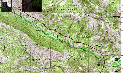
Approach and Trail head map
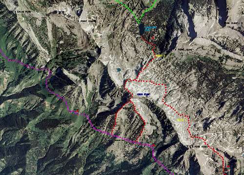
Gros Peak region aerial photo
USEFUL MAPS:
Jackson 30'-------------approaches and trail heads Turquoise Lake 7.5'----Gros Peak area + camping Turquoise Lake orthophoto quad--- aerial views Cache Creek 7.5'-------Cache Creek Trail Gros Ventre Junction-----Goodwin Lake Trail Blue Miner Lake 7.5'---Flat Creek Trail Granite Falls 7.5'-------Highline Trail (east end) + Granite Creek Trail (east end) Bull Creek 7.5'---------Little Granite Creek Trail
There are five trails which will lead one to Gros Peak:
TRAIL NAME TRAIL # USGS QUAD (S) ELEVATION
TRAIL A + D Cache - Granite Creek Trail 003-018 Cache Creek 7.5' 6,440' Granite Creek Trail 018 Granite Falls 7.5' 7,000' (and leads to Highline Trail) (019) Cache Creek 7.5' 8,120'
TRAIL HEAD DESCRIPTION- This is the easiest trail head to get to. Starting at the town square of Jackson, Wyoming drive about one mile east on Broadway to the right turn onto Rancher Street. Follow Rancher Street all the way over to where it ends in a T with Upper Cache Creek Road. Turn left and follow this well maintained road one mile further to Cache Creek Trail head with ample parking.
Cache Creek Trail Map
A little about this trail to the wilderness boundary. Lots of trees, constant stream sounds, steep slopes on both sides, and occasional views of Cache Peak. In other words just a beautiful trail that the people of Jackson are lucky to have.
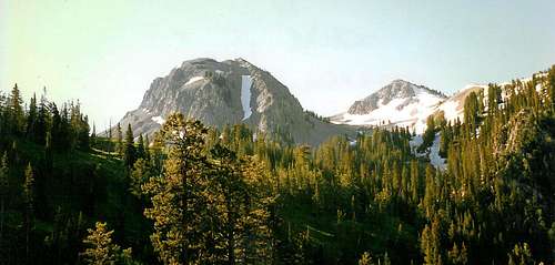
Cache Peak early on a sunny morning
Trail head Elevation----6,440’ Distances---------------6.0 to wilderness boundary ---------------6.5 to Highline Trail jct. --------------10.0 miles to southwest ridge via Highline Trail --------------11.0 to Turquoise Lake via Granite Creek Trail Total elevation gain---3780’ to Turquoise Lake ---5,500’ to Gros Peak summit
-or- (via Highline Trail, western end) ---1,680' to junction with Highline Trail ---3,040' to southwest ridge ---5,140' to Gros Peak summit
The Highline Trail climbs steeply away from the trail head as it rounds the large green ridge coming south away from Terrace Peak. After the ridge, the grade lessens a good deal. At the six mile mark, Little Granite Creek is passed. It is at this point that Route 3 turns towards the head of Little Granite Creek; nice campsites can be had near the two little lakes up there. Continue on the trail another two miles to the start of the southeast ridge. Coming from the west end of the Highline Trail, it is 3.5 miles from the junction with Granite Creek Trail to the southwest ridge. Once past Cache Creek-Horse Creek divide, the long range vistas are spectacular. The trail is aptly named.
On the Highline trail at the Cache Creek- Horse Creek divide
Trail head information for Granite Creek Trail (beginning at the Granite Hot Springs end) Trail head elevation----7000’ Distances---------------10.0 miles to Turquoise Lake Total elevation gain----2600’ to Turquoise Lake ----4320’ to Gros Peak summit
Were it not for the length of the trail to Turquoise Lake, it would be easy to recommend this approach above all the others. Wonderful scenes of a deep canyon complete with a little known seasonal waterfall await the traveler. An especially exciting portion of the hike is finally rounding the Granite Creek bend to see the beautiful alpine uplands ahead. In fact, unless a day hike bid on the peak is to be made; this is still about the most rewarding way to the mountain, excessively long or not.
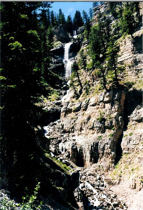
Box Creek Falls, Granite Creek Canyon
TRAIL B Goodwin Lake Trail 016 Gros Ventre Jct. 7.5' 7.960'
TRAIL HEAD DESCRIPTION-
Travel on East Broadway Street about one mile to sign boards indicating the start of the National Elk Refuge. Drive north then east about 3.5 miles to a 90 degree turn to the left. Follow road around turn and then north another mile to the Curtis Canyon Road (FSR-30440). After about three miles this road passes Curtis Campground; uphill 1.5 miles it meets the junction with Sheep Creek Road. Bear right and ½ mile further brings one to the Goodwin Lake Trail head.

Goodwin Lake Trail head Map
This trail starts high and stays high for pretty much the whole run from Goodwin Lake to the junction with Cache-Granite Creek Trail. The only trouble is the path can be a little hard to follow in places, especially near the terminus with Cache-Granite Trail. Just watch for blazes and cairns and in general travel along the foot of the mountain slopes as that is where the trail goes. Taking the above into account, this is still probably a good bet for those wanting a slice of seldom traveled terrain on the way to Turquoise Lake. This trail along with the Little Granite Creek Trail are the two feasible entrances for those bent on day hiking this peak, though unless time dictates, why hurry?
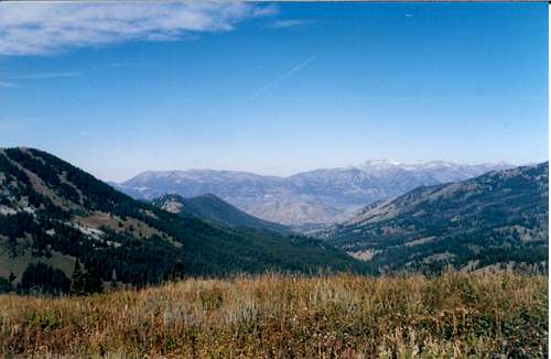
Gros Peak environs from Flat Creek-Granite Creek divide
Trail head elevation----- 7960’ Distances---------------- 6.5 miles to Granite Creek Trail jct. ---------------- 9.0 miles to Turquoise Lake Total elevation gain-----1800’ to Granite Creek Trail jct. -----2520’ to Turquoise Lake -----4220’ to Gros Peak summit
TRAIL C Flat Creek Trail 015 Blue Miner Lake 7.5' 7,440'+-
TRAIL HEAD DESRCIPTION-
To just get to this trail head is an adventure in itself. After traveling across the National Elk Refuge for some 8.5 miles one comes to the forest service boundary and the end of any semblance of a good road. Low clearance vehicles may want to stop right here, but with careful driving another mile or so can be made. With an all-wheel drive or non 4wd truck you can make it to the "parking area" for the start of the Sheep Mountain climbers trail. Now comes the fun part. Personally I enjoy four wheel driving; on this road that is a good thing. What lies ahead on FSR 30442 is about three miles of some of the roughest road that exists in Teton County, so drive carefully! At the end of this track is the trail head. Don't be surprised if in early season you have to drive through some water at the end.

Flat Creek Trail head Map
At the start of the Flat Creek Trail the first mile is spent bypassing Flat Creek Ranch, one of the few forest inholdings in the west. Great views around here of the large lake here and the green canyons walls ahead. It looks like a long ways and it is. The redeeming values are the constant mountains towering above, and the fact that the elevation is spread out over such a long ways that the trail is quite an easy stroll for most of its length.

Upper Flat Creek in a wet year
Trail head elevation-------7,440’ Distances------------------9.5 miles to Granite Creek Trail jct. ------------------12.0 miles to Turquoise Lake
Total elevation gain------ 2580’ to Turquoise Lake ------4280’ to Gros Peak summit
TRAIL D Highline Trail 019 Granite Falls 7.5' 6,795' (east end) 019 Cache Creek 7.5' 8,120' (west end)
TRAIL HEAD DESCRIPTION- Please refer to map and trail head description under Black Peak, Wyoming- Swift Creek Trail head here on summit post. The only change would be that the trail head is exactly opposite the turn for Swift Creek, there being a sign board visible. This of course is talking about the eastern terminus of the Highline Trail, the western end of the trail being 1/2 mile above the Cache Creek Trail- Granite Creek Trail junction.

Heading up the Highline Trail, Terrace Peak ahead
Trail head elevation---------------6,795' Distances--------------------------7.0 miles to Little Granite Creek jct. --------------------------10.0 miles to southeast ridge
Total elevation gain--------------2,360' to Little Granite Creek jct. (due to several ups and downs) --------------3,360' to southeast ridge --------------5,440' to Gros Peak summit
Looking at the summit from just west of Blackman Creek on the Highline Trail
TRAIL E Little Granite Creek Trail FST-022 Bull Creek 7.5' 6,600'
TRAIL HEAD DESCRIPTION- Drive south from Jackson,Wyoming for 13 miles to the Hoback junction. At the roundabout there travel generally east up Hoback River Canyon on us Highway 189 twelve miles to the Granite Creek Road (FSR30500). Notice the cliffs up on the left about 1/3 mile from Granite Creek; this is a small sport climbing area called the Hoback Shield. The cliffs consist of Nugget Sandstone dating from the Jurassic-Triassic transition period. Turning left off the highway, follow the usually good gravel of Granite Creek Road a little over a mile north to just before a bridge over Little Granite Creek . At this point turn left again on FSR 30505 and travel this slightly rougher track two miles north to the trail heads for a total of 28 miles from Jackson, Wy.

Little Granite Creek Trail head Map
The Little Granite Creek Trail is an enjoyable hike that climbs at a steady clip through a lush canyon for about four and one-half miles to its junction with the Highline Trail. This approach appears to be the closest to Gros Peak in mileage, and perhaps is the best bet for turning this trip into a day hike. Must be better than the death march from Jackson, Wyoming to the mountain and back in one day that I did the first time on this peak! The Rough Hollow route I actually prefer. There is a path going all the way up this drainage so little bush whacking is involved. The chief attraction to taking this path instead of the standard trail up Little Granite Creek is that it is too rough for horses!

Looking east from Little Granite Creek-Horse Creek divide
Trail head Elevation----6,600’+- Distances -------------4.5 toHighline Trail jct. -------------7.5 to south-southeast ridge (8.0 to south-southwest ridge) Total elevation gain---2920’ to south-southeast ridge ---5000’ to Gros Peak summit
A WORD ABOUT ROUTE 3
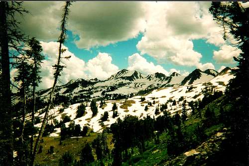
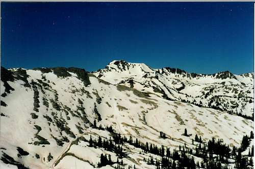
I've visited this mountain several times from different angles but none of these journeys compared to the challenge and sense of discovery felt when I approached Gros Peak using this route. This is a good old fashioned cross country trip through rough terrain with outstanding scenery at every step. While routes 1 and 2 are pretty straightforward, route 3 is open to much interpretation. There are pretty little glacial tarns scattered across this area north of the line of peaks, and plenty of exploring to do in the upper regions of Bunker Creek. In fact, there was enough to see that I was obliged to camp at the lakes just south of point 10,440' and climb the mountain the next day! Here are three pictures to give an idea of what this wild area looks like.
Looking upon upper Bunker Creek drainage from the head of Little Granite Creek
Close up of Pinnacle Peak, the only class 5 peak in the range
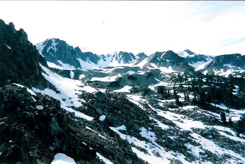
Wild Bunker Creek Basin, about as rugged as the Gros Ventre Range gets
Red Tape
Red tape issues are few except the normal admonitions to treat this area as real and precious wilderness that it is. One should camp away from Turquoise Lake a small distance both for seclusion and because it is also the rule. Also remember to wear bright clothing in the fall during hunting season. Other than that you're on your own out here; carry a map and know how to read it!

Shoe and a butterfly
Early season shot of Gros Peak from the northeast
Camping
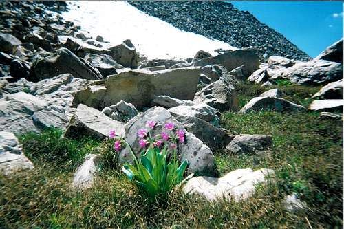
Alpine denizen
Great camping spots can be found around the Turquoise Lake. Another nice alternative to this somewhat popular area is to camp in the upper Little Granite Creek or Blackman Creek head water areas if accessing the peak from along the Highline Trail. See the area approach map above for some choice camping site suggestions.

Turquoise Lake
External Link
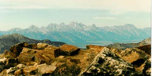
Teton Range from Gros Peak summit
seano - Jun 1, 2017 1:08 pm - Hasn't voted
Little Granite Creek / Rough HollowWhile there is a trail up Rough Hollow as of June 2017, it does not seem to be maintained. Much of the area burned awhile back, and there are many downed trees across the trail, making for slow going. However, the creek is smaller than Little Granite Creek, making the water crossings more manageable, so Rough Hollow may still be preferable.
dino61111 - Jan 1, 2018 11:34 am - Voted 7/10
Re: Little Granite Creek / Rough HollowHey, thanks for that Rough Hollow trail update; if it can be called a trail. They didn't name it that for nothing. I might also add that one can go directly up the slope to the North of parking area. This is the hill between Little Granite Creek and Rough Hollow.
seano - Jan 2, 2018 10:04 pm - Hasn't voted
Re: Little Granite Creek / Rough HollowThanks! I visited that area again last summer, and that seems like the best route from there to the high country for a hiker.