
-
 12697 Hits
-
 86.85% Score
-
 23 Votes
|
|
Mountain/Rock |
|---|---|
|
|
46.68431°N / 11.75743°E |
|
|
Hiking, Skiing |
|
|
Spring, Summer, Fall, Winter |
|
|
8445 ft / 2574 m |
|
|
Overview
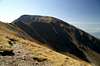
 The South slopes of Großer Gabler The South slopes of Großer Gabler |
There is a small mountain group right in the middle of the Alps - best known as Plose, which appears to be orphaned. You can easily tell that it neither belongs to the Sarntal, Stubai or Zillertal Alps since it is separated from these ranges by either the profound Eisacktal / Valle Isarco or Pustertal / Val Pusteria Valleys. It certainly does not belong to the Dolomites - its whole aspect speaks against this assumption. There is simply no piece of dolomite or limestone rock around and the boundaries of the western Dolomites are Gadertal / Val Badia and Aferer Tal / Val Eores, which also are boundaries to the Plose "Group". Yet still, there it is, not overly impressive but reaching up to 2574m in its highest point, Großer Gabler.
In effect the whole group looks like one of the large pastures you find in the area. Seiser Alm / Alpe di Siusi comes to mind - by far the largest of these pastures, located only a few km to the south. Plose is similarly used: cattle grazing and skiing. A large amount of ski lifts lead to the main crest of the range and the south faces have been developped as ski runs. To the north, however, the mountains suddenly drop of and reveal their origin: the endpoint of some huge moraine, left over from the last ice ages. The mountain does not consist of any definite rock but rather is a conglomerate of any kind of debris you can find. Large parts of the crest have been secured by fences since - especially in wet weather - landslides are not uncommon there.
Großer Gabler / Monte Forca Grande is the highest of these summits, all of which reach between 2400 and 2600m in elevation. They form a curving ridge, but have smooth slopes on their south sides. The traverse from Telegraph / Monte Telegrafo in the west across Große Pfannspitze / Monte Fana and Kleiner Gabler / Monte Forca Piccola is one of the best known hikes of the area. A cable car heads up to an elevation of roughly 2000m and if you lucky, a chairlift will take you close to the telegraph summit. From anywhere on the crest you have very ompressive views towards the mountain groups around but the highlights are the northern view towards the Zillertal Alps Main Ridge and the southern view towards the pinnacles of the Geisler Group. To the east the Prags and Fanes Dolomites loom, which adds to your well-being on the summit.
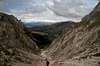
Some guidebooks claim that a small ferrata leads across the north ridge between Kleiner Gabler and Großer Gabler. I wouldn't call it a ferrata myself, just a steep scree ascent with some cables to guide the eye. These cables aren't able to support you in the case of a fall, the whole soil is far too loose for any decent anchor. On the south side, Großer Gabler has a very long and shallow slopes. It is rarely climbed from that part but oftn descended. Once at about 2200m a dirt road takes you back to the cable car station (with numerous alms/huts on the way). Lastly: there is a bivouac hut on the Gabler summit - for whatever reason it might have been built. However, it is a good shelter against the often fierce winds on this windswept mountain group.
|


Dolomites Panorama #1
Piz da PeresDreifingerspitzeParacciaHaunoldEbenköfelDreischusterspitzeSeekofelMonte Sella di SennesRotwandElferkofelKleine GaisslHohe GaisslCristalloNeunerZehnerHeiligkreuzkofelTofana di DentroTofana di MezzoLa VarellaPeitlerkofelMonte PelmoCroda da Lago 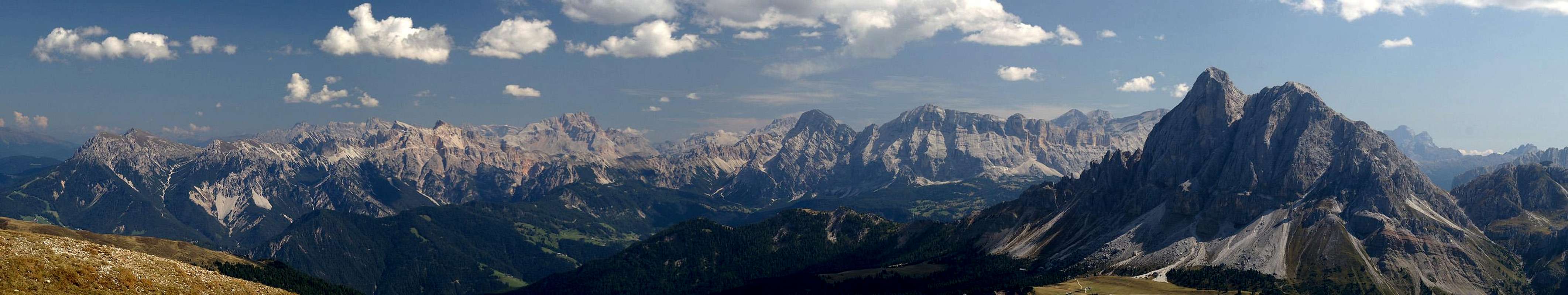  |
Dolomites Panorama #2
TofaneLa VarellaPeitlerkofelPelmoCroda da LagoCivettaRingspitzePuezspitzenPiz DuledaWälscher RingTullenWasserkofelFurchettaSass RigaisWeißlahnspitzeFermeda GroupLangkofelPlattkofelCol MagreiSecedaRoßzähneSchlern 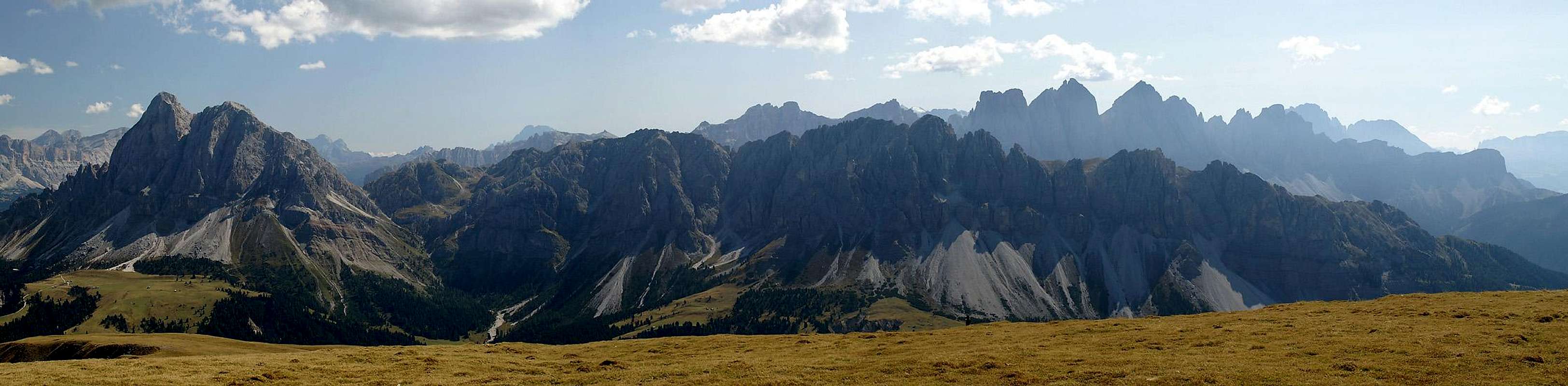 |
Getting There
KampelesspitzeTribulaun GroupHöllenkragenSerlesWeißspitzeRollspitzeFinstersteinKramerspitzeEbengrubenspitzeWilde KreuzspitzePlattspitzeGrabspitzeRotwandWurmaulspitzeHohe WandSchrammacherFußsteinOlpererFlituidenkopfWeißspitzenHochfernerHochfeilerHoher WeißzintBreitnockGr. MöselerKl. MöselerTurnerkampEidechsspitzeGrubbachspitzePassennockGraunockHornspitzenReisnockSchwarzensteinGroßer LöfflerKeilbachspitzeWollbachspitzeNapfspitzeLöffelspitzeRauchkofel  |
While there are several locations from which you can explore the little Plose range, the best starting point is St. Andrä / San Andrea above Brixen / Bressanone. Here a cable-car leads up above the timberline of the mountain.
To reach the cable-car take the Brenner Motorway A22 and leave it at the exit Brixen / Bressanone. Take the Brenner Highway SS12 south until you reach the town. Drive through its centre, always following the signs to Plose, St. Andrä and Würzjoch / Passo selle Erbe. The cable car station is located a little above the village of St. Andrä.
Red Tape
There's no real red tape on Plose except for the military antennae on top of Telegraph (guess where it got its name!). These are fenced in with barbed wire and look like any military installation. The buildings, however, are not used anymore. Also take care when following the ridge towards Großer Gabler. There are a lot of fences there too, but these fences are to protect you from the loose north faces of the Plose mountains.Accommodation
There are many possibilities where to stay in the region. The following links give but an excerpt of the multitude of possible locations.- Brixen / Bressanone accommodation
- Sterzing / Vipiteno accommodation
- Pustertal / Val Pusteria accommodation
- Gadertal / Alta Badia accommodation
- Villnöß / Val di Funes accommodation
Weather Conditions
Maps & Books
Maps
- Digital Maps
- Regular Maps
- Brixen / Bressanone
Kompass Map WK 56
1:50.000
ISBN: 3-85491-063-0
- Brixen / Bressanone
Books
- Dolomiten 1
F. Hauleitner
Rother Verlag
ISBN: 3-7633-4248-6