
-
 16136 Hits
-
 83.69% Score
-
 17 Votes
|
|
Mountain/Rock |
|---|---|
|
|
42.69382°N / 0.01274°E |
|
|
Hiking, Mountaineering |
|
|
Spring, Summer, Fall |
|
|
10656 ft / 3248 m |
|
|
Overview
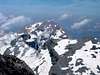
 The wide summit
The Marboré (3248m), in spite of being one of the higher and most important mountains of the valleys of Ordesa and Gavarnie dominating with its great presence the cirque of Gavarnie, it's one of the mountains less climbed of the zone due to its locating. It's situated in the middle of the normal ways of walk of Ordesa and Gavarnie and its ascent is long and very bad signaled and for this reason the mountaineers choose other peaks as Monte Perdido (3355m), Cilindro (3328m), Casco (3006m), Torre (3009m) or Taillon (3144m).
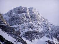
 Marboré,NW face
The 2 normal routes from Spain suppose generally to spend the night in some of the 2 availables refuges, Góriz or Sarradets. Although the climb from Ordesa with 1950 meters of slope is practical for mountaineers well trained, so across Góriz or across Cotatuero, in more than 6 hours, it's advisable to spend the night before descending of the mountain for not surpass the 11 hours of walk.
From the French side the road of the Col de Tentes offers the possibility to carry out the climb in only one day surpassing 1,000 meters of slope but the itinerary is also long and generally requiring 5 hours to reach the top.
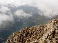
For these reasons it's a mountain generally destined to people that knows the zone and they had climbed already to the other big mountains of Ordesa and search a new experience with new landscapes. The enormous and rounded top offers a pretty view above all the cirque of Gavarnie and as Russell said is so extensive that would be able to maneuver a regiment (to what we would say nowadays that would be able to play a soccer or football match).
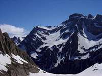
 North Face
Of all the options to climb the peak Marboré nowadays the route from Góriz is the most frequented but in my opinion I don't consider as normal because the route is not easy to find for the people new in the area. Probably it's the most secure route and easiest technically. The route from Sarradets have a pass of I+ with a metallic rope in the Paso de los sarrios and with snow is dangerous for the people without experience.
 |
 |
 |
 |
 |
Getting There
 Gavarnie
Gavarnie:
From Toulouse or Tarbes we drive in direction to Lourdes. From Lourdes, follow to Luz-St-Saveur, from there on there should be signs to Gavarnie or Gedre. There is a good asphalt road up the col de Tentes with a parking of cars. See more information in the page of Refuge de Sarradets
Ordesa:
From Zaragoza to Huesca, excellent highway. Road N-330 to Sabiñánigo, across the tunnels of Monrepos. After Sabiñánigo you have to get road N260 north for 13 km and turn right at Biescas following the road C-138 (road signs "Ordesa"). Then you cross the Col of Cotefablo and after 24 km turn left at the crossroads marked Torla. From that point on it's only 2 km to the parking lot or 8 km to the pradera de Ordesa.
Red Tape
The peak is located in the natural park of Ordesa.The National Park Regulations are the following:
- Free camping is forbidden. It's permited to vivouac or camp using a tent lower than 1.3 m/ 4 ft 3.25 in, wich would be taken down at dawn. This practice is allowed above these heights:
Ordesa area: 2.100 m (Clavijas de Soaso)
Añisclo area: 1.800 m (Fuen Blanca)
Escuaín area: 1.800 m (La Ralla)
Pineta area: 2.500 m (Balcón de Pineta / Marmoré)
- Sports aside hiking, climbing, ski-mountaineering and speleology are forbidden.
- The sale of commercial products is not allowed
- It's forbidden to swim in the rivers, streams and lakes
In french side you can camp in a place far of more than 1 hour of a refuge over 2000m.
Camping
 Astazu & Marboré
See the section above for the rules about to camp in the area.
To sleep in the night you had a lot of hotels and some campings in the villages of Torla and Gavarnie.
Refuges:
-Ref.de Sarradets (2587m, 85 places). Tel:62924063.
-Ref.de Goriz (2190m, 100 places) Tel:974-341201.
Campings:
Spain:
-Camping Bujaruelo: camping and refuge.
-Camping Río Ara (Torla)
-Camping de Fenes (Bujaruelo).
France:
-More than 10 campings in the area of Luz St Sauver, Gedre, Gavarnie: Campings65: list of the campings of Pays Toy with webs and mails.