
|
|
Mountain/Rock |
|---|---|
|
|
42.59750°N / 123.879°W |
|
|
Curry |
|
|
Hiking |
|
|
Spring, Summer, Fall |
|
|
5298 ft / 1615 m |
|
|
 Brandy Peak
Overview
This is one of those little known peaks in the coastal mountains of Oregon, found between the Pacific ocean of the Oregon coast and I-5, the main highway that goes north to south in Oregon. Yet, it is a peak that does interest more than just locals and hunters. Want some reasons?Brandy Peak has two reasons why it is important enough for peakbaggers to chase after it. Brandy Peak is the county highpoint of Curry County and has the ninth highest amount of prominence of the 73 Oregon Prominence peaks. There might be a third reason, a view but I can't vouch for that as I had the poor luck along with SP'er Bob Bolton to visit this peak on a rainy, foggy day. The signature picture is as good as it got the day I was there so another trip back to the area is in the works so I can capture some more pics. However, the reason I have gone ahead and posted this peak is that something very negative happened in the area.
The recent tragedy of James Kim occurred not far from Brandy Peak and although Brandy Peak wasn't mentioned in the news releases, I had an awareness of where the drama had unfolded thanks to having summitted Brandy Peak back in 2003.
James Kim tragedy
Many of you remember the recent story about a family who got stuck in the snow and were stuck there for 11 days. This occurred not far from Brandy Peak and brought back to me that this area can be treacherous in the wintertime. Anyway, the father of the family, James Kim tried to hike out to get help but they found his body in the Big Windy Creek drainage. All of this is near Brandy Peak. Read the Wikipedia story found HERE Road 23, aka as Bearcamp Road is the road that gets you close to Brandy Peak.

Of course, an unfortunate article in a local newspaper appeared about how the father of James Kim blamed everyone, including the brave men and women of the search and rescue crews, for his son's death without focusing on the fact that his son made, some very poor choices. James Kim's death was a loss and a tragedy, but to blame others is unacceptable. See this link for more on that aspect of this story. In time, the above article will most likely disappear (it recently did disappear and so the link I had was removed). I do want to praise the search and rescue people, they to me are unsung heroes. They are willing to risk their lives and put themselves in dangerous situations to try and save another. Ladies and gentlemen, if you are participants in a search and rescue team, I salute you and thank you.
Getting There

From I-5, head to Galice from any of a number of exits between Wolf Creek and Grants Pass. Just south of Galice, go west on Galice Road, signed to "Agnes" (0.0 mile). This road eventually becomes FS#23 when it enters the National Forest. Stay on the main paved road and follow signs to Agnes. Near Bear Camp, turn left on dirt road FS#2308 (at 20.4 miles). Follow this dirt road southwest to the saddle on the ridge northeast of Brandy Peak (at 23.9 miles). Park here (at 4,680 feet) or nearby and pick your way up to the summit. A GPS coordinate was very helpful to us in the lousy weather conditions we encountered.

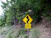
The road is generally paved but is narrow, often only one lane or a lane and a half. This is one road that you can't be in a hurry on. Note the
sign below
Red Tape
There is no need for a forest pass as there is no trailhead even though Bob has one displayed. Just park off to the side of the road as shown in this picture and head via GPS readings toward the peak, taking the most logical path you can find. We did encounter a trail at one point but what trail system it belonged to was not understood. Our trailhead, a wide spot in the road.
Be sure to contact the ranger station listed below prior to going as the road is often undergoing repair or closed due to damage from slides.
Do not attempt this road in wintertime. Several fatalities have occured when people have gotten trapped or stuck in the snow. Do not ignore any warning signs you might encounter.
Rogue River-Siskiyou National Forest
Galice Ranger District (Grants Pass Interagency Office)
Pam Bode, District Ranger
2164 N.E. Spalding Avenue
Grants Pass, OR 97526
Phone:
Voice: (541) 471-6500
Fax : (541) 471-6514
 Looking west towards the Rogue River & Pacific.
Camping
Here are a few possibilities:Bear Camp Pasture CG
This is the closest one to Brandy Peak Note also it only has one campsite.
Others in the general area:
Big Pine Campground
Meyers CampCG (note this has only 2 campsites)
Other possibilities can be found by contacting the ranger station and at one time I had links to each campground but the links were broken when the forest service changed their server.
There may be a few spots that you could find that would work for car camping. Check with the ranger district to find out if that is allowed.
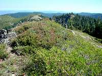 View north from Brandy's summit area
Weather

Be sure to watch for a "shoe tree" a mile or two down the road.
 Famous shoe tree
Route description

Our effort involved less than two miles of hiking and 600 feet of elevation gain. I can't give a trail description since we did it in the rain and the slopes and vegetation were slippery (slimey) and I landed on my butt more than once on the way down. Had we known there was a trail, we might have looked for it but we had preset GPS coordinates and just went from there.
The map below is a rough idea of our route but is shown only to give you an idea of the terrain and our not so well documented way up.
------------------------------------------------------
We did find that this area has a trail (which we crossed as we cross countried up to the peak from where we parked our vehicle. From a FS info sheet comes this info:
"Description: A short trail that runs along Bear Camp Ridge, the highest portion of the Galice Ranger District. This trail offers spectacular views, a wide variety of wildflowers and cool summer time hiking. Wildlife and wildflower viewing, pleasantly cool high elevation hike in the summer months.
Trail goes 1.5 miles down Bear Camp Ridge and comes out at road 2308 and spur road 016 (to Elk Wallow dispersed camp), along road 2308 for a few hundred feet then up to Elk Wallow Viewpoint. The second Trailhead is approximately 4.0 miles down the 2308 road. At this Trailhead is the 0.5 mile section to Craggies Viewpoint and an approximate 4 mile hike to Squirrel Camp which goes under Brandy Peak (an undeveloped path can get you to the peak). There is another undeveloped trail to Squirrel Peak, elevation 4,400 feet at Squirrel Camp.
Access: From Grants Pass take I-5 North to the Merlin exit 61, follow Merlin/Galice road. to the Galice Creek access road 34-8-36. Continue up this road approximately 21 miles to the junction of Forest Service road 2300 and 2308 to the trailhead."
I found a county highpointer report that includes information on the Brandy Peak trail. Although Bob and I didn't find this trail, we did stumble across it in our cross country ascent. Click HERE for that Trip report.
Maps
3.4 miles in from the junction with FR 23, watch for the TH sign
Don Nelsen's TH pic

County Highpointing
Oregon is very diverse and the state has 36 counties. To get all of the county highpoints, you must climb Mt. Hood and climb over barb wire fences in eastern Oregon. All in all, county highpointing is like a treasure hunt with each county revealing its treasure as you travel to it, and through it. Unknown places become a goal and in the end, when you have completed the state, you have climbed the likes of Hood, Jefferson, McLoughlin, Thielsen and Eagle Cap. You have also found your way to ranches, high desert backways and gems you knew nothing about. Gems? How about Strawberry Mountain in the John Day area or Steens Mountain in east central Oregon. For fun and games, check out this web site, www.cohp.org to get a feel for this.Here is a link to some trip reports posted by others
In Oregon, I still have Mt. Jefferson to climb to finish the state but hopefully 2007 will allow me to do that.
One more picture of the top spot & other tidbits
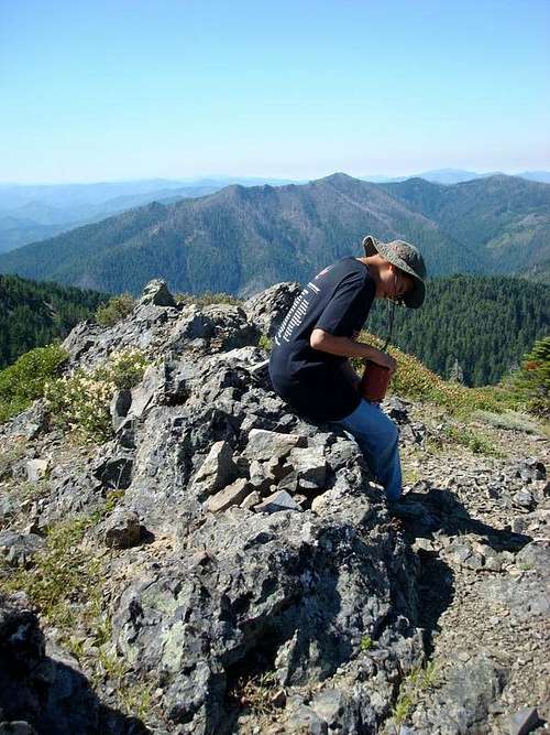 Reading the register
 Squirrel?
 The original name of Brandy Peak? This is a pic of one of the witness
Benchmarks found at the summit. Squirrel? Oh, I did find information
that there used to be a "Squirrel Camp". Just to the west of Brandy Peak, the map shows Squirrel Camp Creek and a bit further to the west, see this TOPO,
Squirrel Peak. Is it possible that perhaps the surveyors nailed the wrong peak? I can assure you that we weren't on the wrong peak since we both had independently put the coordinates for Brandy Peak into our GPS's. As forested as this area of Oregon is, it is a possibility that they put the Benchmarks on the wrong peak or had the name wrong. Still, in order to solve this mystery, more research is forthcoming....
don't forget to sign the register
This pic by Don Nelsen shows the register placed at the summit. Look for the red can.
Also found near the summit

A bit about Curry County
The county was named for George Law Curry, territorial governor of Oregon for much of the time between 1853 and 1859. As of 2000, the population was 21,137. The county seat of Curry County is Gold Beach. Why is this town called Gold Beach?In 1852 explorers discovered gold and other precious metals in the rivers and along the beaches of this area. As a result, settlement in the county was concentrated along the coast, depending primarily on water transportation. The slow development of inland transportation routes kept the county relatively isolated well into the twentieth century. While there is still some mining of cobalt, nickel, and chromium in the Gasaquet Mountain area, the economy has reoriented to agriculture and timber. Port Orford cedar (also known as Lawson's Cypress) and myrtlewood are important export products.
The county also raises cattle and sheep. The county also produces blueberries, horticultural nursery stock, and 90% of all Easter lilies raised in the United States. Tourism is also important to Curry County as US 101 runs along the coast and channels tons of tourists up and down the Oregon coast. The Forest Service owns 59% of the land within the county boundaries.
The Rogue River is also a favorite attraction for rafters and visitors