
-
 19337 Hits
-
 90.47% Score
-
 32 Votes
|
|
Mountain/Rock |
|---|---|
|
|
38.66823°N / 111.64108°W |
|
|
Sevier |
|
|
Hiking |
|
|
Summer |
|
|
11624 ft / 3543 m |
|
|
Overview
Mount Marvine, also known as Sawtooth Peak, or the Blade, is the enduring remnant of a high volcanic plateau. Landslides, wind and water erosion gradually stripped away hardened ash and lava deposits, leaving only a narrow, jagged profile of rock. As a testament to this erosion, the mountain is surrounded by 54 square miles of landslide debris.Some have compared Mount Marvine's profile -when viewed from the north- to the much grander Matterhorn. Without a doubt, the same forces of nature that carved the Blade also helped craft Monte Cervino and its neighbors.
Part of the massive Marysvale Volcanic Field, the peak's flanks are covered in over 300 meters of densely welded, vesicle-poor pyroclastic flow deposits overlying Paleocene Flagstaff Limestone. These volcanic deposits were left from an ancient eruption of nearby Monroe Peak Caldera.
In layman's terms, the mountain is made of really rotten rock.
Seven-Mile Valley passes along the southern edge of the mountain, winding its way through several large glacial moraines. These moraines are the
largest in the area, deposited by several 2 to 4 mile long glaciers. At several points, you can look up the canyons surrounding Seven Mile Valley and see the high cliffs from which the glaciers descended.
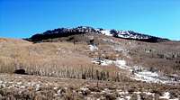
Mount Marvine's slopes were battered and scorched by a wildfire in 2002; however the vegetation is making a steady recovery.
The peak is located in Utah's Fishlake Wilderness, less than 2 miles from the area's namesake. On a clear day, the summit offers some of the best views in south-central Utah. Points often visible include Fishlake Hightop, the Mytoge Mountains, Mount Terrill, Windstorm Peak, Thousand Lakes Peak, Steves Peak, the Henry Mountains, The La Sal Mountains, Mount Nebo and Capitol Reef National Park.
Mount Marvine is ranked #94 in Utah by prominence.

Getting There
As long as your vehicle has reasonable clearance, you should be able to access most of the roads around Mount Marvine. Even low clearance vehicles can access Seven Mile Valley once the winter snows have melted.
From Richfield, Utah
From I-70 take exit 119 in Richfield. Follow 119 east through the town of Glenwood and up to the junction with Highway 24. Take 24 south past Koosharem Reservoir until it climbes to meet Highway 25 (toward Fish Lake).
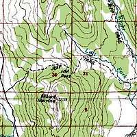
Follow Highway 25 northeast past Fish Lake and Johnson Valley Reservoir. At the northwest corner of Johnson Valley Reservoir is a dirt turn off. A sign proclaims this to be Seven Mile Valley. Follow this dirt road (NF-319) for about 1 mile. Mount Marvine will be visible on your right. While passing near the northwest side of the peak you will reach a jeep trail leading northeast toward the summit ridge. A sign marks this as the way to UM Pass. Follow this trail until it reaches the high ridgeline at an elevation of about 10,400'. Park here or slightly farther down the trail near Lost Fork Creek. There are no marked trails here. In order to reach the summit, one must scramble up the NW slope. The easiest route, "Martin's Ladder", follows the ridge as it curves SE. stay with the spruce trees as high up the ridge as possible, which is as high as 100 feet below the summit ridge as of summer 2012. Expect a minimum of Class III exposure in some spots.
Do not attempt to climb from the north or NE, as the rock is far too rotten to make a safe ascent. It's possible, but dangerous.
From Loa, Utah
Take Highway 24 northwest to its junction with Highway 25 toward Fish Lake. Follow the above directions.
Red Tape
Mount Marvine is located in Fishlake National Forest. No permits are necessary unless you want to cut firewood.
Camping
Camping within the Fish Lake Basin is restricted to designated camping areas, of which there are many. Lodging is available nearby at Bowery Haven Resort and Fish Lake Lodge, located along the northwest shores of the lake.Within Seven Mile Valley, dispersed camping is allowed anywhere on public land, as long as litter is removed and fire/dumping restrictions are followed.


External Links
Fishlake National Forest.Weather forecast for Torrey, Utah. Mount Marvine is cooler by an average of 15 degrees fahrenheit.

Scott - Jan 24, 2007 12:06 am - Hasn't voted
Matterhorn comparisonSome have compared Mount Marvine's profile to the much grander Matterhorn. Although I wouldn't venture this comparison, the forces of nature that contributed to the Blade, also helped craft Monte Cervino and its neighbors. If you are curious, the mountain does look somewhat like the Matterhorn, but only when viewed from the North Ridge. From all other sides, it bears no resemblance to the Matterhorn and has a different appearance.
Eleutheros - Jan 24, 2007 12:23 am - Hasn't voted
Re: Matterhorn comparisonI've seen the north side while hiking near Porcupine Spring and up by Sheep Valley Reservoir. Wish I had some photos but I was only 11 years old at the time. It seems like you've been everywhere in Utah. That's awesome. Congratulations on Chimbo too.
Pfeiffer75 - Aug 15, 2012 2:02 pm - Hasn't voted
PictureI have a picture I took from Mount Terrill and it does somewhat look like the Matterhorn from this angle. I will post it
peakbaggerwolf - Jul 24, 2017 9:57 am - Hasn't voted
Now pavedThe road from 25 to the jeep trail is now paved. This was definitely a hard hike, especially in the rain. The debris/boulder field reminded me of King's peak and there is a pretty good little section of climbing to get to the summit. Maybe it was just my poor route finding abilities.