
|
|
Mountain/Rock |
|---|---|
|
|
42.14915°N / 13.63197°E |
|
|
Hiking, Mountaineering |
|
|
Spring, Summer, Fall, Winter |
|
|
7703 ft / 2348 m |
|
|
What's new
Few time ago, the Monte Sirente page was already posted. Paretenord, if I remember well the name of the owner, edited a very good page, reach of original information for hikers and climbers. Suddenly, he decided to delete the page and to disappear himself from Summitpost site: I don't know and I don't remember why. This new page originates from only one personal experience ascending the Monte Sirente in winter (a first attempt was 2 years ago, but the bad weather stopped me) and certainly needs improvements in terms of photos and description. I hope in the valuable support of all the SP members (mainly from Central Italy).
- Febraury 2007: start-up of the page
- May 2008: Route added by RenatoG
- Febraury 2007: start-up of the page
- May 2008: Route added by RenatoG
Overview
The Appennino Centrale (Central Appennines) offers a lot of options to hikers and climbers and Monte Sirente surely represents an interesting target. It is placed in the heart of the Abruzzo’s mountains, within the Regional Park of Sirente-Velino. Together with the villages of Ovindoli and Rocca di Mezzo, famous ski-centres of the Abruzzo, it is the main attraction of the area.
The morphology is characterised by a complex group of edges, valleys and minor summits connected with two others important mountains of the area: Monte Velino and Serra di Celano. Monte Sirente (2348 meters) is the highest summit of a long chain of about 20km running in the direction NW-SE. A lot of minor summits (or elevations) characterise the chain, such as Punta Macerola (2258m), Monte di Canale (2207m), Monte San Nicola (2012m). As usual for most of the Appenines of calcareous rocks, great differences characterise the sides of the mountain chain.
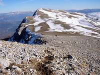
![Monte Sirente, N-side]() view from the N-side
view from the N-side
The morphology is characterised by a complex group of edges, valleys and minor summits connected with two others important mountains of the area: Monte Velino and Serra di Celano. Monte Sirente (2348 meters) is the highest summit of a long chain of about 20km running in the direction NW-SE. A lot of minor summits (or elevations) characterise the chain, such as Punta Macerola (2258m), Monte di Canale (2207m), Monte San Nicola (2012m). As usual for most of the Appenines of calcareous rocks, great differences characterise the sides of the mountain chain.
 view from the N-side
The North-Eastern side, growing from the green Subequana Valley, is basically rocky and steep, while the South-Western side slows down gently with meadows and pastures towards the surrounding valleys.
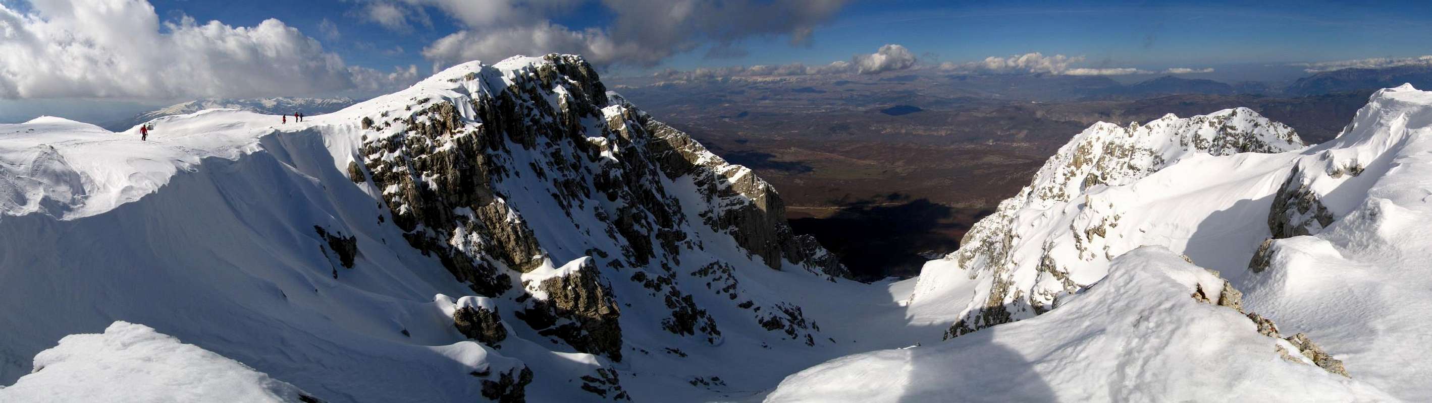
![Monte Sirente, S-side]() View of the S-side
View of the S-side
 View of the S-side
But the most important characteristic of Monte Sirente are a lot of wide gullies and little valleys of glacial origin, cutting the North-Eastern side of the mountain:
- Canalone Maiori (or Valle Inserrata);
- Valle Lupara;
- Valle della Neviera;
- Canalone San Vincenzo;
- Canalone di Monte Canale.
[img:269646:alignleft:small:Canalone maiori and rocky spurs
- Canalone Maiori (or Valle Inserrata);
- Valle Lupara;
- Valle della Neviera;
- Canalone San Vincenzo;
- Canalone di Monte Canale.
[img:269646:alignleft:small:Canalone maiori and rocky spurs
The steep gullies represent the access of most routes to the summit and some of these are very important for the old history of the local population. The Valle della Neviera, meaning more or less “the valley of the snow plant”, was in the past a natural storage of ice: the freezer didn’t exist yet!. The inhabitants of the villages, from the XVI century to the XIX century, ascended the valley up to natural (or sometimes artificial) hollows where the ice kept till the summer. The pressure done by the upper strata of snow on the lower strata gave rise the formation of very hard granular ice crystals. Each village, such as Secinaro, Gagliano Aterno or Fontecchio, had its own snow factory (“neviera”) and the literature reports that the snow, maintained under suitable condition with dry leaves, was delivered even to Bari, several hundred kilometres far on the Adriatic coast.
![Descending from Monte Sirente]() Descending along the SE-ridge
Descending along the SE-ridge
 Descending along the SE-ridge
Beautiful woods (Beeches), carsic sceneries, open and green meadows, steep rocky spurs and walls are the typical environment encountered by people interested in hiking in this area. The panorama offered to the hikers changes depending on the side you choose for the ascent. Monte Sirente and its steep and wide gullies, mainly the Canalone Maiori, are also a great attraction for ski-mountaineers.]![La Neviera]() "Neviera"
"Neviera"
 "Neviera"
From the top of Sirente you have a complete view of the main mountains of the Abruzzo: the Gran Sasso massif (Corno Grande and close summits),Monte Velino and Majella.
Getting There
The main starting points for the routes of the North side are close the village of Secinaro (837m) while, if you decided to hike from the South side, the starting point is Aielli-Vado Castello(1544m).
From Rome: The fastest way is the Highway A24-Roma/L’Aquila, take the Highway A25 towards Pescara and exit at Aielli-Celano. For the North-Eastern acces to the Monte Sirente, take the Regional road SR5bis till Ovindoli (1414m). Continue following the SR5-bis and before the village of Rocca di Mezzo turn right in the direction of Secinaro. The road descends arriving at the starting point of the normal route to Monte Sirente, called Fonte all’Acqua (1150m), few kilometres before the village of Secinaro. Parking area in front a burned chalet. For the Southern access, from the Highway exit go towards Aielli and contiune up toVado Castello.
Route Overview
The way to the summit is not always easy. Particularly from the North side, you have to pass through a very beautiful but intricate wood, and the trail are not clearly marked. In winter, when the snow covers the ground, finding the right direction can be difficult. Only in the first parts of the ascent recently few indications have been placed. Depending on the snow condition crampons and ice-axe could be requested.
![M.te Sirente Canale Majori]() Canalone Maiori
Canalone Maiori
|
 Canalone Maiori
Both from South and North side the ascent is quite long (more than 1200 meters by the N-side).
North-East side:
- From Fonte all’acqua (1150m) , following the gully of Canalone Maiori-Valle dell’Inserrata 4:00-5:00 h ascent. For the descent following the Val Lupara about 2:30-3:00 h. It’s possible the inverse trail, ascending from Val Lupara. This is considered the normal route to the summit;
- From Fonte all’acqua (1150m) , following the gully of Canalone Maiori-Valle dell’Inserrata 4:00-5:00 h ascent. For the descent following the Val Lupara about 2:30-3:00 h. It’s possible the inverse trail, ascending from Val Lupara. This is considered the normal route to the summit;
South-side:
- From Vado Castello (1554m) following the Valle Spagnoletta-Monte San Nicola and SE-ridge – 4:00-5:00 h ascent. For the descent by not marked trail towards the Stazzo di Cristo and the Prati di Santa Maria (about 2:30-3:00 h).
![Canalone Maiori]() the final step of Canalone Maiori
the final step of Canalone Maiori
- From Vado Castello (1554m) following the Valle Spagnoletta-Monte San Nicola and SE-ridge – 4:00-5:00 h ascent. For the descent by not marked trail towards the Stazzo di Cristo and the Prati di Santa Maria (about 2:30-3:00 h).
 the final step of Canalone Maiori
Monte Sirente means not only hiking but also climbing. Some hard winter routes on the rocky spurs connecting with the upper ridge of Monte Sirente or on the wall of the NE-side of the closest summits of the ridge (such as Punta Macerola) were climbed for the first time in the recent past.
North-East side (winter routes):
- Right Spur of the “Neviera” (2255 mt): “Via delle Affinità elettive”, height about 400m, rated AD+, max 60° on ice and snow. First ascent on January 2000 by G. Guzzardi, A. Condemi, L. Angeletti;
- Right Spur of the “Neviera” (2255 mt): “Via Grande Nord (E-ridge)”, height about 700m, rated AD+ / III, max 60° on icy and snowy couloirs. First ascent on April 1999 by G. Guzzardi;
- Punta Macerola (2258m) ): “Via Antartica”, height about 900m, rated TD / IV, max 75° on the crux. First ascent on February 2003 by G. Guzzardi.
Red Tape
No fees and parking pass are required. You are in the Regional Natural Park of Velino-Sirente and you must respect the specific rules stated for the protection of the environment. This is the widest Regional park of Italy(about 60 hectars).
The area is famous, from the astronomic point of view, for the presence of the first Italian site of impact of a meteorite. A circular crater was discovered in the recent past and listed on 2003. It is placed in the Prati del Sirente, close to the village of Secinaro. It is one of the smallest craters in the world but its peculiarity is the really recent origin (1600 years).
When to climb
Monte Sirente can be ascended all the year. The relevant difference in altitude between the starting point and the summit (about 1200 m from the N-side) and the long approach, from the S-side, suggest to avoid the hottest season. I ascended in winter season the N-side, even if in poor snow condition, and it should seem to be better and fun than in summer thinking to the long and tiring gravely gullies.
In case of need and help you can call the phone number 800.25.82.39, operating in all the Abruzzo region.
An international reference for weather forecast can be the AccuWeather, web site. In addition, a useful site is the Aeronautica Militare-Servizio Meteorologico web site (In Italian).
Refuges and accomodation
No refuges are available as base for the ascent to Monte Sirente. Possible accommodations are in Ovindoli and Rocca di Mezzo.Book & Maps
Two books in Italian including not only routes towards the Monte Sirente but even in Abruzzo and in the Regional Park:
- Stefano Ardito "A piedi in Abruzzo", 2003 (in Italian). Guide ITER (Subiaco, Roma) – ISBN 88-8177-029-6;
- Narciso Galiè, Gabriele Secchioni “Parco Regionale Sirente-Velino-Le più belle escursioni”, 1999 (in Italian). Edited by Parco Regionale Sirente-Velino and Club Alpino Italiano-Società Editrice Ricerche – ISBN 88-86610-12-2
The main maps are:
- CAI (Delegazione Abruzzese) – “I sentieri della provincia de L’Aquila. Gruppo Velino-Sirente” CdC L’Aquila (1:25000);
- IGMI Fogli n° 146 III NE (Monte Sirente), 146 III SE (Pescina), 146 IV SE (Tione degli Abruzzi), 145 IV SE (Magliano dei Marsi).