
-
 40521 Hits
-
 82.48% Score
-
 15 Votes
|
|
Mountain/Rock |
|---|---|
|
|
34.11628°N / 118.94042°W |
|
|
Ventura |
|
|
Hiking, Toprope, Bouldering |
|
|
Spring, Fall, Winter |
|
|
2838 ft / 865 m |
|
|
Introduction
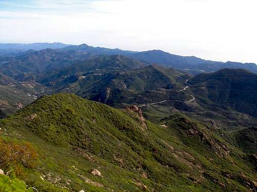
Boney Peak, also known as Mt. Boney, is a low, rugged mountain guarding the northern terminus of the Santa Monica Mountains National Recreation Area. The peak is part of Boney Mountain, a small plateau that contains the four highest peaks in the Santa Monica coastal range, including Sandstone Peak.
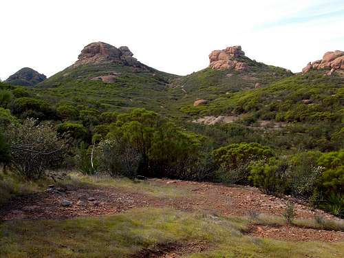
The plateau has various andesite breccia outcroppings and formations that provide decent bouldering opportunities. Top rope and single pitch routes ranging from 5.4 to at least 5.10a can be found along various rock faces east of the peak near the conjunction of Yerba Buena Road and the Sandstone Peak trailhead.
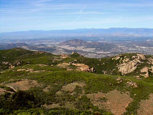
The summit commands sweeping views of Ventura County, Westlake, Malibu, Point Mugu State Park and the Pacific Ocean. On a clear day the Channel Islands are visible to the west. Despite its modest elevation, Boney Peak rises dramatically from Sycamore Canyon near Camarillo. Much of its north and western face is marked by a 1,500 foot precipice lined with jagged formations and rocky crags.
Big Sycamore Creek carves colorful fissures in the mountain's northern ramparts as it cascades to the valley below.
Directions
Boney peak is accessible through the western edge of the Santa Monica Mountains National Recreation Area, and Rancho Sierra Vista in Newbury Park.
From Malibu
Take the Pacific Coast Highway (1) to Yerba Buena Road. Follow this for about 5.5 miles or until you are about 1 mile East of Circle X Ranch in Malibu. Park at the turnoff near Triunfo Pass. Here, the Backbone Trail ascends the Boney Mountain Plateau. Less than 1 mile from the trailhead a dirt path turns off to the left, ascending a steep incline. Here one finds a short, easy scramble to the summit of Sandstone Peak - the area highpoint.
To reach Boney Peak, stay on the Backbone Trail and continue past this junction for 1/4 mile. Boney Peak is the next major prominence to the south (left) side of the trail. Several unamed footpaths branch off toward the peak. Some bushwacking may be required to reach the andecite outcropping that forms the summit bloc. Be warned that Santa Monica chaparral makes for a rough bushwhack.
Note: If you reach Inspiration Point, or two white water tanks, you have gone too far.
From Westlake Village
Take Westlake Blvd south from the 101 Freeway. Follow until it merges with Mulholland highway. Turn right onto Little Sycamore Canyon, which becomes Yerba Buena Road. Proceed on Yerba Buena for about 4 miles to the trailhead or about 1 mile before the Circle X Ranch Ranger Station.
No permits are required to climb Boney Peak.
To see a National Park Service map of the Boney Peak area click here.
Mountain Conditions
For conditions visit or call:
Santa Monica Mountains National Recreation Area
401 West Hillcrest Drive
Thousand Oaks, CA 91360
Visitor Center:(805) 370-2301
Maps & Links
Circle X Ranch National Park Brochure & Trail Map.
USGS 7.5 min. Triunfo Pass, Newbury Park.
tarol - Feb 18, 2010 11:54 am - Hasn't voted
Links brokenSeveral links on the page are broken and need to be updated - otherwise great page :)
Eleutheros - Mar 6, 2010 3:45 pm - Hasn't voted
Re: Links brokenThanks for letting me know! I'll fix them shortly. -Eleutheros