|
|
Mountain/Rock |
|---|---|
|
|
42.12210°N / 117.9255°W |
|
|
Malhuer |
|
|
Hiking |
|
|
Spring, Summer, Fall, Winter |
|
|
8027 ft / 2447 m |
|
|
Stevenson BM

Overview
In the far southeast corner of the state of Oregon lies the Stevenson BM, the highest point in one of the USA's largest counties. Malheur county ranks number 11 in sheer size and is about as empty a county as you can find anywhere in the US. The county is not mountainous with 94% of it being rangeland and with the Bureau of Land Management controlling 72% of the land, it is pretty much run and regulated by the federal goverment.The county seat is Vale Oregon, a long ways from where this county highpoint is located and the largest town in the county is Ontario, located on I-84 about an hour from Boise.
Stevenson BM is not a lofty summit but is more of a highpoint on a ridgeline that you can see from U.S. 95
The highpoint is closer to McDirmitt, on the Oregon-Nevada border and one of the few places where you can find gas or food (and a few slot machines). The above link to McDermitt will give you all the information you need. The biggest town of any size that is close to the highpoint is Winnemucca Nevada so you get a feeling that you are a long way from anywhere, particularly if you need a tire repair (more on that later).
Oregon has 36 counties and for those who are into collecting county highpoints, the highpoint of Malheur county is one that must be reached, despite its isolation and the nasty roads that get you there. As far as a climb or even a hard hike, this doesn't rank high on anyone's difficulty scale but the area has its own unusual beauty that makes it worthwhile in its own right. Most people associate trees and rain with Oregon but this area is high desert. You'll find little rain here and no trees. It is scrubland with lots of sage and range grasslands.
In the fall the hunters flock here, a hardy group with six ply tires and a desire to have sucess in their annual hunt. Many hunters return here yearly so be forewarned that if you go in the fall, or even late August, you will not be alone in this area.
As I mentioned just a bit earlier, this area has a beauty all of its own and I recently saw the area all decked out with a wintry coat as I traveled by on US 95 during February. I had a highway patrol car behind me so I did not pull over to take some pictures. Oh yes, the speed for ALL Oregon highways (other than the interstates) is 55 MPH. Keep an eye out for the highway patrol and county mounties, they do get out to this back area of Oregon.
Getting There & The Hike
Rather than explain how to get to this area from Portland, Boise or even Timbucktoo, the best way to get you to the highpoint is to first locate McDirmitt. Once you are at McDirmitt, follow these instructions that were put together by county highpointer Ken Jones as I can't improve on his directions:This one is almost all approach, the hike is trivial. The BLM's Vale District Recreation Guide (basically, a 1:100000 scale map with updated roads) is helpful.
From U.S.95 about 15 miles north of the state line take road 6302-0-OO which heads west toward the Oregon Canyon Mountains. It is not well signed. Here's our road log, with some minor forks ignored:

0.0 U.S. 95
2.7 fork to Oregon Canyon road, keep right
8.2 another fork to ranch, go right
9.6 turn left, towards ridge
10.5 continue straight toward ridge, ignore right fork
12.5 pass water tank on hillside
14.4 ridgetop junction, keep left (stay high)
15.6 keep left (stay high)
16.0 keep left (stay high)
19.0 keep left (stay high)
22.2 stay on main road
23.7 keep left on ridge road
24.7 keep left on ridge road
26.4 go left at intersection, you're getting close
29.9 we parked here, where road drops steeply down to N/NE
Walk through open terrain scattered with glittering obsidian, crossing fence line, about 1/4 mile to the summit and benchmark.
For a bit more information on this route, see this trip report
-----------------------------------------------------------
 Early morning deer
Another way in was reported by San Diego county highpointer Richard Carey:
Dates: August 15-16, 2006 Author: Richard Carey
Note: Waypoints are NAD27 in Zone 11.
My friend Gail Hanna and I decided to approach this mountain from the west. This seemed most efficient since we were coming south from Steens Mountain. We made it through and camped up on the high plateau west of the highpoint which we drove to the next day. This route requires four-wheel drive, high-clearance; but goes OK.
Driving Route (west approach)
On Oregon highway 292, about 8.5 miles south of Fields, turn east onto Whitehorse Ranch Road (203). Drive this wide gravel road for 27.4 miles to the area of the ranch and turn right (south) onto a fair dirt road which is 40 ft. west of a sign describing historic Camp Smith. This road is Mud Springs Road, but is not signed. Note the following mileages on this route with major junctions indicated, avoid minor spurs and stay on the best road.
0.0 At Whitehorse Ranch Road junction.
Coordinates are (398850 E, 4687830 N).
3.4 Go left at a junction. Road goes around a butte on your right.
5.6 Road comes in on your left, continue straight ahead.
7.9 Junction with road going due south. Go left on road heading SE.
12.2 Pass Buckaroo Corral Reservoir staying left at possible junction.
13.1 Road goes north around Mud Spring (dry in late summer).
14.0 Stay right at triangle junction (rough road with lava rock).
Hunter's camp in trees along here.
14.5 Go right at junction.
16.6 Road ascends steep, rough hill (4wd needed).
21.1 Stay to the left at possible junction.
24.0 T junction. Reach east-west road that goes across plateau.
Coordinates here are (418450 E, 4662885 N).
Turn left here and head east toward the highpoint.
27.1 Reach a gate in a fence line on your right. Park here and
cross fence and walk east up to final summit with Stevenson BM.
Highpoint coordinates are (423497 E, 4663544 N).
For a bit more on this route, see this trip report
 Looking south
Red Tape & Weather
None that I am aware of. No permits or passes required but should you encounter a gate, be sure to leave it as you find it (open or closed)
Camping
You can car camp in many places but there are no organized campgrounds in the area. A Casino-Motel is available in McDirmitt or further on in Winnemucca Nevada. Winnemucca is around 70 miles to the south of McDirmitt.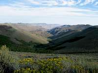 Just north of the BM
When Bob and I visited the area, we just found a spot off of the road that runs along the plateau. We noticed many of the hunters in the area, just found campsites similar to the one we had but I would always recommend that you clean up after you are finished and help keep the area clean.
Nearby mountain suggestions
Blue Mountain, a prominence peak is found just a few miles north off of US 95.You can easily combine Blue Mountain (a rugged drive up) with a visit to the Stevenson BM. Another county highpoint within reasonable driving distance is Nevada's Granite Peak, the highpoint for Humboldt County.
Trip reports indicating vehicle problems
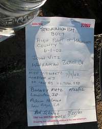
Report number one:BM Stevenson (8,027 ft)
Date: July 22, 2002
Author: Barney Metz
Adam Helman and myself went to Frenchglen, OR and south on OR-205. We went left and east on Whitehorse Ranch Road. We tried to approach Mahleur from the west, but we could never make the road connections that we needed in this extremely desolate land. We continued west on the Whitehorse Ranch Road to US-95. Proceeded south and followed Ken Jones's accurate trip report to the CoHP.
Note: This route was extremely rocky and tough. I have a high clearance vehicle and four wheel drive and this was not an easy route. I have no idea how Andy martin or Ken Jones drove passenger cars up there if that was the vehicle they used. There are many cow roads up there that local ranchers use to tend their herds. Due to the sheer poor condition of the road we decided to try to drop down to Trout Creek to the west and come out in McDermitt, NV. The road was in overall better condition, but high clearance vehicle would be highly recommended. I lost the notes on how to get there from McDermitt, it is longer in distance, but slightly better in road conditions.
As we were heading down from the BM Stevenson to Trout Creek, we had a flat. We tenderly limped along the road until we hit Disaster Peak Road -- low and behold we had another flat. We walked about 4 miles along this road to McDermitt before a rock hound who gave us a ride into McDermitt picked us up. We ended up spending the night in McDermitt while Robert Mitchell, the local mechanic, gave a ride the next morning to Winnemucca, NV to have the tires replaced. We finally had the Suburban up and running 18 hours later. We headed north to Canyon CoHP.
-----------------------------------------------------
Report number two:
BM Stevenson
Dates: August 16-17, 2005
Author: Ron Tagliapietra
Disaster! We had rented a Pacifica (4WD but no high clearance). We got to the last T-intersection with a gate on the right and parked. We jogged much of the way to the hp and back racing sunset. Decided to go out an alternative route, since the road had been so bad. We hoped that this was the alternate road in a trip report but we knew it was on our Rand McNally map. We drove about 1.5 miles through the gate and decided to sleep.
Next morning, we got about 10 more miles before a rock ripped out the gas line. By then, we had passed most of the bad parts but hit the one rock in the road. We didn't know it but we were 32 miles from the nearest town (McDermitt, NV). I have AAA and Dan had a cell phone but it kept cutting off while trying to call. Three ranchers in a truck drove by and said they would give us a lift on their way back out to McDermitt. They did, about 4 hours later, and the drive took an hour. After more phone calls, we went back to the car, where we learned that a tow was not possible with the wheels on the ground. Back to town. The rental company wanted it delivered to Boise, Idaho. Another guy from Rome, Oregon, (an hour away) came out with a flatbed and took us back up to the car at dusk. It took him 3 hours to drive to McDermitt and then he continued to Boise, arriving about 10 AM the next morning. By the time we did the paperwork and found an alternate rental company, it was after noon. His sacrificing, all-night drive to Boise salvaged our plans for Granite Peak, MT.
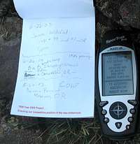
The Benchmark and register
 Summit poser pic
Interesting register pages
 More popular than you'd think