
-
 18696 Hits
-
 83.1% Score
-
 16 Votes
|
|
Mountain/Rock |
|---|---|
|
|
40.33440°N / 124.1104°W |
|
|
Humboldt |
|
|
Hiking |
|
|
Spring, Summer, Fall, Winter |
|
|
3600 ft / 1097 m |
|
|
Overview


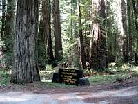
Access to Rainbow Ridge is through Humboldt Redwoods State Park. You have to drive through the fabulous Rockefeller Forest of Redwoods to get to the trailhead. The hike is anticlimactic after driving through the redwoods.
DanBaxter adds "Rainbow Ridge can be easily hiked the same day as King Mtn, if you wish. To do this one drives through the hamlet of Honeydew. The trailhead has no signs whatsover, and can be easily bypassed. Reset your odometer at Honeydew Junction. The TH will be at 9.8 miles, on your left.
I left the Kings Pk TH, incidentally, at 9:33 a.m., and arrived 1 hour and 16 minutes later at the Rainbow Ridge TH."
SPer DanBaxter adds "There is a second point on the ridge with a contour above 3600'. If you like to follow the guidelines of such groups as the COHP group, you will need to ascend this one as well. It is at UTM 10 404421E 4467385N (NAD27). It is about 1 1/2 miles to the NW of the described HP, and can be seen from the same. Interestingly, the 2 named peaks on the USGS topo map (Rainbow Pk & S Rainbow Pk) are not the two HP's! The NW summit is sharper sloped, and felt higher, but my GPS elevation was drifting > 50 ft and I could not confirm it. The route in between the 2 HP's is easy, a road with mild slopes until the last dash, but it still added nearly another hour to my trip (and that with a mountain bike), and made me feel downcast and annoyed, in part because I was already tired from the long drive the previous night and ascent of King Pk earlier that day, and in part because I felt quite exposed in this largely open terrain of dubious legal access."
Getting There

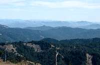
Head west on the little road into the Rockefeller Forest and to Honeydew. This road is paved but it soon becomes very narrow and crooked as it winds its way through the redwoods. Drive slowly and enjoy the view. 5.0 miles from Hwy 101 you will pass Albee Campground on your right and in another .3 mile you will emerge from the redwoods and the road gets better. Stay on the main road and pass the Bull Creek Pioneer Memorial Cemetery at 8.4 miles from Hwy 101. At this point the road starts climbing with several sharp switchbacks. Watch your speed and climb up to a ridgeline saddle at 11.9 miles from Hwy 101. Stop here and notice the gravel road going north with a brown gate. This is the trailhead and the elevation here is about 2,290 ft.
SPer DanBaxter adds "The first part of the described route is quite legal. There are no posted signs at the Mattole Road gate, nor on the trail (dirt road) as it passes north just inside the state park border until it reaches Dennis Poulin's waypoint "RainA". At that point, however the public trail passes right into the park, and the route to Rainbow Ridge enters private land, which a sign destinctly states. There are several signs on route, usually high on a tree, which destinctly include "no trespassing". Nothing in these signs gave me the impression that they did not include the private road. The land is owned by the Pacific Lumber Company, as I recall. There are no closed gates or fences that you need to climb, however. The No Trespassing sign at the open gate before the first HP is right on the gate post, at a more reasonable height, and leaves one with no doubt that you are not allowed to be there.
Because of leveling for the towers at the first high point, the true HP is indistinct. I sensed that the land just outside the tower fences at the two entry gates at the N end of the fencing is probably highest, so one need not go into the tower compound itself."
See the Route Description for info on the trail and finding the summit of Rainbow Ridge.
Red Tape

Humboldt Redwoods State Park
or call the Visitors Center at 707-946-2263
Camping

There really is plenty of room on the summit to pitch a tent if you are so inclined. It could be very windy on the summit at times.
Contact the Humboldt Redwoods State Park for camping information or call 707-946-1818.
When to Climb
Mountain Conditions
This mountain is accessible in all seasonsFor current weather conditions in Eureka follow this link
Eureka, California
danbaxter - May 9, 2007 1:42 am - Hasn't voted
2nd HP on RidgeThere is a second point on the ridge with a contour above 3600'. If you like to follow the guidelines of such groups as the COHP group, you will need to ascend this one as well. It is at UTM 10 404421E 4467385N (NAD27). It is about 1 1/2 miles to the NW of the described HP, and can be seen from the same. Interestingly, the 2 named peaks on the USGS topo map (Rainbow Pk & S Rainbow Pk) are not the two HP's! The NW summit is sharper sloped, and felt higher, but my GPS elevation was drifting > 50 ft and I could not confirm it. The route in between the 2 HP's is easy, a road with mild slopes until the last dash, but it still added nearly another hour to my trip (and that with a mountain bike), and made me feel downcast and annoyed, in part because I was already tired from the long drive the previous night and ascent of King Pk earlier that day, and in part because I felt quite exposed in this largely open terrain of dubious legal access. Dan Baxter
Dennis Poulin - May 9, 2007 12:29 pm - Hasn't voted
Re: 2nd HP on RidgeThanks Dan for your valuable input. I've incorporated your comments on the main page. Are you doing N. Pal this year? Dennis
danbaxter - May 9, 2007 1:57 am - Hasn't voted
Legal AccessThe first part of the described route is quite legal. There are no posted signs at the Mattole Road gate, nor on the trail (dirt road) as it passes north just inside the state park border until it reaches Dennis Poulin's waypoint "RainA". At that point, however the public trail passes right into the park, and the route to Rainbow Ridge enters private land, which a sign destinctly states. There are several signs on route, usually high on a tree, which destinctly include "no trespassing". Nothing in these signs gave me the impression that they did not include the private road. The land is owned by the Pacific Lumber Company, as I recall. There are no closed gates or fences that you need to climb, however. The No Trespassing sign at the open gate before the first HP is right on the gate post, at a more reasonable height, and leaves one with no doubt that you are not allowed to be there. Because of leveling for the towers at the first high point, the true HP is indistinct. I sensed that the land just outside the tower fences at the two entry gates at the N end of the fencing is probably highest, so one need not go into the tower compound itself. Dan Baxter
danbaxter - May 9, 2007 2:04 am - Hasn't voted
Driving distancesRainbow Ridge can be easily hiked the same day as King Mtn, if you wish. To do this one drives through the hamlet of Honeydew. The trailhead has no signs whatsover, and can be easily bypassed. Reset your odometer at Honeydew Junction. The TH will be at 9.8 miles, on your left. I left the Kings Pk TH, incidentally, at 9:33 a.m., and arrived 1 hour and 16 minutes later at the Rainbow Ridge TH. Dan Baxter