
|
|
Mountain/Rock |
|---|---|
|
|
34.81350°N / 119.1663°W |
|
|
Kern |
|
|
Hiking |
|
|
Spring, Summer, Fall |
|
|
8818 ft / 2688 m |
|
|
Overview
A hop skip and a jump away from Mount Pinos, the highpoint of Ventura County, is Sawmill Mountain. Sawmill Mtn. has the highpoint for Kern county on its summit which helps to make it worth the extra hiking time from Mt. Pinos to go visit this nearby mountain. There is a bit of controversy about the actual highest point in Kern county and I've touched on that in another section.Another interesting piece of information is that Kern County is the 19th largest county in the lower 48 and that in and of itself was interesting to me as I am also interested in reaching the top of the 50 largest counties in the United States.
The easiest way to access Sawmill Mountain is by going over the top of Mount Pinos. A trail continues on from the top of Mt. Pinos and drops over the western side and switchbacks down to a saddle from which it then climbs back up towards the top of Sawmill Mtn. More information on that is provided below.
 Highest spot on Sawmill Mtn.
Getting There
From either L.A. or Bakersfield, leave I-5, take the Frazier Park/Mt. Pinos exit. (If coming from L.A., you will go over Tejon Pass) Go west on the Frazier Park Road for about seven miles to a junction with the Lockhart Valley Road (on the left) which is at Lake of the Woods. At the junction, one road goes left one mile(Lockhard Valley Rd) to a ranger station which is a good place to go if you need an adventure pass or information. If not, take the right fork which is the Mt. Pinos Road (used to be called the Cuddy Valley Road) and go five miles to the Mill Portero road which should be signed for Mt. Pinos. Turn left up this road and follow it as it twists and turns its way up the mountain to a large parking area (9 miles) which serves the Mt. Pinos Nordic area (when there is sufficient snow). Keema's nice pic of Sawmill Mtn
Red Tape
Avoid getting a ticket:Adventure parking passes are required. They can be obtained at the ranger station in Lockwood Valley or any BIG 5 Sporting Goods store; $5 for a day pass, $30 for a year pass.
For more information:
Mount Pinos Ranger District
District Ranger: Tom Kuekes
34580 Lockwood Valley Rd.
Frazier Park, CA, 93225
Phone: 661-245-3731, Fax: 661-245-1526,
[img: 285796:alignright:small:Big Sawmill Mtn cairn]
Camping
There are several campgrounds in the area:Chula Vista (walk in)
Mt. Pinos CG (nearby)
McGill CG (nearby)
Some information about the above can be found HERE.
Weather

Route
The easiest way to access Sawmill Mountain is by going to the Mt. Pinos nordic ski area parking lot and walking up the road to Mt Pinos. From the top of Mt. Pinos, a good trail switchbacks down the west side to a saddle between the two mountains located at you drop down to a saddle at 8320 feet (topozone)Upon reaching the saddle, the trail begins to ascend again and will take you close to the summit area of Sawmill Mountain. A good use trail leads off of the main trail which continues on to Sheep Camp. As you near the summit, you will see a large cairn on the western end of the ridge and when I was there, there was a register in a red can that you could sign. However, the actual highest spot on the ridge is back about 80 feet or so and you will see some low laying boulders off to the side of the use trail. When I was there, there was a small glass container that held a sheet of paper that many others had already signed. They felt that the highpoint of Sawmill Mountain was at this point.
Now, there is a spot on Mt. Pinos that could actually be the highest spot in Kern County and that is shown in this picture. See the section below for more commentary on this.
Actual hike distance from Mt. Pino TH:
6 miles roundtrip
The elevation gain via the Mt. Pinos route is: Roughly 1800 feet overall
Up to Mt. Pinos , down to the saddle, up to Sawmill Mtn, down to the saddle and then back up to the top of Mt Pinos and down to the TH.
 Register page
Here is a great Trip Report on a visit to Sawmill Mtn and Mt. Pinos.
Scott Surgent's Trip Report
So, is the highpoint of Kern county on Sawmill?
There has been much speculation and study of county lines, topographical maps and checking in the field on this subject. I personally felt that the high spot was the area of rocks just north of the Mt. Pino's highpoint but others feel that it is on Sawmill Mountain. Here are some reports posted by others at cohp.org that may (or may not) shed some light on the subject. Before checking those, let me comment that to a person who pursues county highpoints, if there is any doubt, you go to any place that MIGHT be the highpoint. Even Gary Suttle in his book suggested that you go to both areas.Dave Covill's Report
Michael Swartz's Report
Aaron Maizlich's Report
Gerry Roach's Report
Jon Buyun's Report
Layne Bracy's Report
Well, after reading the above you will get a feel for the subject. I tried a line of sight (using the horizon) and felt that the rocks (on Mt. Pinos) seemed higher. Then when I was on Sawmill Mtn, I sighted back and felt that I felt lower on Sawmill. I'm no expert and it was just a gut feeling but the key thing is that both mountains are close enough together that it is worthwhile to cover both areas. The exercise is well worth it (except in 100 degree heat).
Any one else who has been on both mountains in the search of the highpoints is welcome to chime in via the comment section. Thanks one and all.
 Maybe this is the HP?
Chumash Wilderness Area
As you head west off of the summit area of Mt. Pinos and head towards Sawmill Mountain, you enter into the Chumash Wilderness area. The 38,150 acre Wilderness area was named in honor of the Indians that used to roam this area, the Chumash Indians. The wilderness was created by the U.S. Congress in 1992 as part of the Los Padres Condor Range and River Protection Act. The same legislation also established the Sespe, Matilija, Garcia, Machesna Mountain, and Silver Peak wildernesses. Today the Wilderness area is administered by the Los Padres National Forest.From Wikipedia, we learn the following:
"Vegetation within the wilderness includes chaparral at lower elevations, and conifers at higher elevations. Some of the badlands near the southern edge of the wilderness are almost barren of vegetation, and include steep slopes with knife-edge ridges. Snow is frequent from fall until late spring at the highest elevations. Rain is rare in the summer, and fire possible.
Characteristic fauna of the wilderness include black bear, mountain lion, as well as the endangered California condor; the wilderness is at the heart of the historic range of these large scavengers."
More info can be found HERE.
Information about Kern County
Thanks to Wikipedia for the following information:Established in 1866, it extends east beyond the southern slope of the Eastern Sierra Nevada range into the Mojave Desert, and includes parts of the Western Indian Wells Valley, and Northern Antelope Valley, north of Los Angeles County, an area larger than the state of Massachusetts. From the Sierras the county extends across the floor of the San Joaquin Valley to the eastern edge of the Temblor Range, part of the Coastal Ranges. To the south the county extends over the ridge of the Tehachapi Mountains. As of the 2000 census, its population is 661,645, but recent California Department of Finance estimates place the county population at 779,869. The county seat is Bakersfield (since 1874) with the original county seat being the former mining town of Havilah in the mountains between Bakersfield and Tehachapi.
The county has a large agricultural base and is a significant producer of oil, natural gas, hydro-electric power, wind-turbine power, and geothermal power. As of 2004, Kern remains California's top oil-producing county, with over 85% of the state's 43,000 oil wells. The county accounts for one-tenth of overall U.S. oil production, and three of the five largest U.S. oil fields are in Kern County. Kern is also noted for its mineral wealth, including gold, borite, and kernite.
Edwards Air Force Base, China Lake Naval Air Weapons Station, and Mojave Spaceport are located in Kern County (the latter owned and operated by the county government)
Kern County is home to California's largest open pit mine at Boron, which mines borax.
The American Lung Association ranked Kern County as the most ozone-polluted county in the nation in 2006.
History
The Kern County area was first claimed by the Spanish in 1769. In 1772, Commander Don Pedro Fages became the first European to enter the area; the expedition entered via the Grapevine Canyon (later the site of the Ridge Route along U.S. 99 and now Interstate 5). Walker Pass was discovered in 1834 and is an important pass across the Sierra Nevada as it is one of the few not closed by winter snows. It is now a National Historic Landmark. In 1848, the Kern area was ceded to the United States as part of the transfer of California, Nevada, and Utah and other lands under the Treaty of Guadalupe Hidalgo.
Kern County was created in 1866 with the county seat located in the now abandoned mining town of Havilah. In its beginning, Kern County was dominated by mining in the mountains and desert. The area of the San Joaquin Valley was considered inhospitable and impassable at the time due to swamps, lakes, sharp tule reeds, and diseases such as malaria. This changed when settlers started draining lands for farming and constructing canals, most dug by hand by hired Chinese laborers, to both irrigate and drain these lands. Within 10 years the area of the San Joaquin Valley surpassed the mining areas as the economic influence of the county, and the county seat was moved from Havilah to Bakersfield in 1874.
Tensions between Native Americans (mostly Mohave and Paiutes) following attacks on miners and encroaching settlers in the mountains turned deadly on several occasions. Most notably the ghost town of Keyesville is the location where 5 Indians were killed in cold blood in 1856, and another 35 in were killed by soldiers in the 1863 Keyesville Massacre. Relations with other tribes were more cordial. The Haidu lived on the Tejon Ranch under General Edward Beale's protection on Ranchos. Beale and the Chiefs of the tribes got along very well to the point where Beale would give whatever the Chiefs asked for off his own person. The Yokut Indians of the San Joaquin Valley were peaceful and friendly. There were no reported problems between them and settlers. Spanish explorer Father Francisco Garces befriended the Yokuts at villages at the present day Garces Circle and across the railroad tracks from the campus of Bakersfield High School both in Bakersfield. They lived in Hogans along the different branches of the Kern River Delta and hunted antelope, tule elk, deer, grizzly bear, fish, and game birds. The Yokuts for the most part died from diseases, with a few assimilating into the white man's culture. The Haidu assimilated into the local population with most intermarrying with Spanish/Mexican Californios. Many of the Paiute still live in the mountain areas of eastern Kern County, with no reservations in Kern County as in other counties.
Kern County was formed in 1866 from parts of Los Angeles and Tulare Counties. The county derives its name from the Kern River which was named for Edward Kern, cartographer for General John C. Fremont's 1845 expedition, which crossed Walker Pass. Local legend has it Kern had the river named after him by Carson after he nearly drowned in the river which turned into a raging torrent due to summer snowmelt before the Isabella Dam was built in the 1950s. The Kern River was originally named Rio Bravo de San Felipe by Father Francisco Garces when he explored the area in 1776. Kern County was nearly named Buena Vista County for the large, and now drained, Buena Vista Lake between Bakersfield and Taft.
Kern County was the site of the Battle of San Emigdio. It was between Indians of the Santa Barbara Mission who rebelled against the Mexican government taking over mission property and ejecting the Indians. This battle between Mexican forces from Monterrey occurred at the canyon where San Emigdio Creek flows down San Emigdio Mountain and the Blue Ridge south of Bakersfield near Highway 166.
Former U.S. Ambassador and U.S. Army General Edward Beale established and owned the large Tejon Ranch in the mountains south of Bakersfield. It was the consolidation of four separate Mexican Rancheros he purchased in 1846 after his part in winning California independence in the Bear Flag Revolt against corrupt and inept Mexican government officials. Today, the Tejon Ranch is the largest tract of privately owned land in California. The Beale Memorial Library, Beale Avenue, General Beale Road, The Beale Memorial Clock Tower, Beale Park, and Truxtun Avenue are named after the influential Beale family, both for Edward and his wife, and their son Truxtun.
In 1854 the First Regiment, U.S. Dragoons established Fort Tejon near the head of the Grapevine Canyon. The post's mission was protecting peaceful Indians living on the nearby Tejon Indian Rancherias, as well as safeguarding miners from raids by hostile Mohave and Paiute Indians. The Indians of the Tejon Ranch, most of whom were Haidu, assimilated into the local population and the Rancherias no longer exist. Located next to the Ridge Route (now Interstate 5) just north of the town of Lebec, the fort is a California State Historical Park featuring living history programs and Civil War re-enactments (although no Civil War battles were fought there).
Elk Hills, one of the largest oil fields in Kern County, was involved in the affair remembered as the Teapot Dome Scandal, the most infamous example of corruption of President Warren G. Harding's administration. In 1923 it was revealed that Harding's Secretary of the Interior, Albert Fall, transferred portions of the naval petroleum reserves into private hands without competitive bidding, and in the case of Elk Hills, in exchange for personal 'loans.' The illicit deals involved the reserves at Elk Hills and at Teapot Dome in Wyoming.
On July 21, 1952, an earthquake with epicenter in Kern County measuring 7.3 on the Richter scale killed 12 people. The Kern County earthquake was the largest earthquake to strike Southern California since the Fort Tejon earthquake of 1857 and the Lone Pine earthquake of 1872, causing immense and widespread damage. In addition to 12 fatalities, it was responsible for at least 18 injuries and over $50 million in property damage. It was followed by several aftershocks, at least 20 of which were magnitude 5.0 or greater. The quake occurred on the White Wolf Fault and was the second strongest quake in California history, second only to the 1906 San Francisco earthquake.
As home to Edwards Air Force Base the Air Force's main flight test facility, Kern County has been the site of many aeronautic milestones, including the first supersonic flight and the first landing of the Space Shuttle. Kern County is also the home of the first inland spaceport in the United States, the Mojave Spaceport. Kern County is also home to the China Lake Naval Air Weapons Station at Ridgecrest where many weapons used by the Navy were and continue to be developed and tested, including the Sidewinder missile.
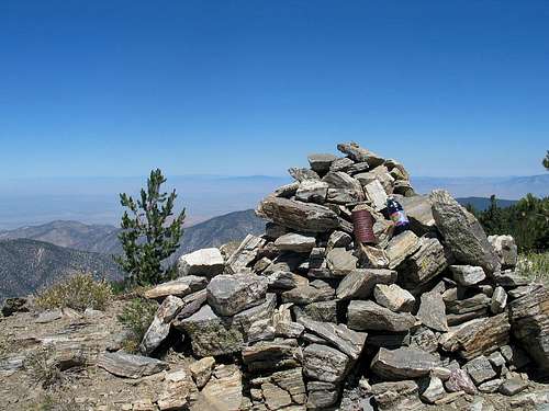 Largest cairn on Sawmill but not at the actual highspot