
|
|
Mountain/Rock |
|---|---|
|
|
55.39720°N / 3.3531°W |
|
|
Dumfries and Galloway |
|
|
Hiking, Mountaineering, Mixed |
|
|
Spring, Summer, Fall, Winter |
|
|
2411 ft / 735 m |
|
|
Overview:-
This fine ridge in the Moffat Hills region of Scotland is best done as part of a circular route when accessing the summits of Hart Fell or White Coomb.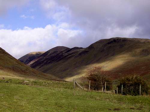 The Saddle Yoke Ridge seen from the village of Capplegill
Although primarily a predominant and elongated ridge, Saddle Yoke, as it is called consists of two summits. One of these high points has the status of a Donald called Under Saddle Yoke at 745 metres and its other top known as Saddle Yoke at 735 metres. This fine ridge jutt's out on the southern side of the Moffat Hills overlooking the deep glacial cut valley of Moffat Dale. This is where the ridge is best ascended from. The two peaks of this ridge when seen from many angles look like two perfect twin pyramids. The thing with Saddle Yoke is being a set of peaks on the kind of ridge mean you can if accessed from the Moffat Dale, head only one way up and the same way down NOT-GOOD. This is something I do not like when it comes to walking the hills.
 |
 |
 |
 |
There are two other stunning ridges that jutt off of the Moffat Hills. These are both in perfect view when ascending the Saddle Yoke. These two ridges are that of the Carrifran, a fine ridge to the east with impressive steep sides and cliffs. The other is that above the valley of Blackhope Scar that leads out on to the summit of Hart Fell via Swatte Fell. Blackhope Scar is a large glacially cut valley torn out of the Moffat Hills region many years back in the previous ice age. The cliffs on the opposite ridge are known as Black Craig, Coomb Craig and Falcon Craig. These are fine cliffs and If you have a bit of spare time a quick walk up the vast open scar valley and its towering cliffs overlooking you is well worth it.
  |
Getting There:-
Saddle Yoke is best accessed from the Scottish Towns of Moffat in Dumfries and Galloway or Selkirk in the Scottish Borders. The place to start when accessing Saddle Yoke is in my route on White Coomb called White Coomb via Saddle Yoke.A section of map covering Moffat and the Moffat Hills from streetmap
 Moffat Hills area map Saddle Yoke is marked just SW of White Coomb
Accessing Moffat via motorway:-
Situated just off Junction-15 of the A74(M) motorway that links Carlisle and the M6 motorway in England through to Glasgow makes Moffat such an easy town to get to. The M6 motorway links with the main cities in England such as Birmingham and Manchester and is also the longest stretch of motorway in the UK.
Junction-15 of the A74(M) is with the A701 Dumfries to Edinburgh road and Moffat is clearly signposted from this junction on the motorway. It is also clearly signposted from Dumfries town centre.
From Edinburgh the A701 is the main link road from the A702 Edinburgh bypass head south via Penicuik and Peebles then head all the way up the Tweed Valley through to Moffat.
From the eastern area head for the town of Selkirk and then take the A708 road signposted for St Mary’s Loch and Moffat. This road when travelled along for the first time can seem a long tedious drive because it is narrow in places and winds round for about 30 miles before you reach Moffat. The one thing is the scenery on this road makes it worth it.
Bus services available to Moffat are from:- Dumfries, Carlisle, Selkirk, Glasgow and Edinburgh. The Edinburgh service runs via the towns of Penicuik and Peebles.
The nearest main railway station is that of Lockerbie a town just to the south of Moffat which also has bus services to Moffat. So a journey part by train and part by bus is available. The station of Lockerbie is situated on the high speed line from London Euston to Glasgow. This line also has connections with Birmingham New Street and Manchester Piccadilly.
Major airports with international connections and car hire companies are plenty:- Newcastle International airport just on the east side of England is about a 100 mile drive away from Moffat. The Scottish airports with international connections are them of Edinburgh, Glasgow and Prestwick. Moffat is within an easy drive, train or bus journey from all these airports.
View Larger Map
Navigation with Ordnance Survey Maps:-
Saddle Yoke being in the Moffat Hills area strangely falls across more than one Landranger 1:50 000 Ordnance Survey map but is covered across the area of four different sheets. This can make things difficult carrying loads of maps but Ordnance Survey have a 1:25 000 map that covers the complete area available in both paper sheet and laminated waterproof plastic. Maps for the area are listed below with details of areas they cover.
Ordnance Survey 1:50 000 Landranger series:-
Landranger 72 Upper Clyde Valley – Biggar and Lanark
Covers Tweedsmuir and Talla Reservoir
Landranger 73 Peebles, Galashiels & Selkirk – Tweed Valley
Covers Cappercleuch and St Mary’s Loch
Landranger 78 Nithsdale & Annandale – Sanquhar & Moffat
Covers Moffat town Moffat Dale, Annan Dale and the summit of Hart Fell
Landranger 79 Hawick & Eskdale – Langholm
Covers Loch of the Lowes, Moffat Dale, Loch Skeen / Skene and the summits of Lochcraig Head and White Coomb.
Ordnance Survey 1:25 000 Explorer series:-
Explorer 330 Moffat & St Mary’s Loch – Megget Reservoir
Covers the complete area of the Moffat Hills along with the Ettrick Hills in the south region and part of the Manor Hills with Broad Law in the north region.
Ordnance Survey 1:250 000 Road series:-
Road map 3 Southern Scotland and Northumberland
Covers the roads from the northern reaches of England around Carlisle across to Newcastle. The map also covers the southern area of Scotland down from Oban and Dundee.
Ordnance Survey Website Link:-
Ordnance Survey
Access and Red Tape:-
There is no red tape out on the hills of Scotland.The only thing I will say is respect the lower reaches of the valleys around the farms and peoples gardens.
Local Weather details:-
Always before planning any trek or venture on the mountains make a check on the weather. I am not saying everyone is stupid but there are some people that just dont think...?The BBC 5-Day weather forecast for Moffat is via this link:-
Moffat BBC 5-Day Weather
Bed and Breakfast - Accommodation and Camping:-
The area surrounding these Moffat Hills has many market towns that offer the services of hotels and bed and breakfasts etc:-These are just some links for the Moffat area:-
Moffat Bed and Breakfast GOOGLE Search:-
BedandBreakfast-Directory.co.uk ( Moffat )
Moffat Camping GOOGLE Search:-
ukcampsite.co.uk ( Moffat )
Camping is also available in the wilds of the hills but look after the countryside whilst out there.
More about wild camping by searching on this site:-
Other towns within easy reach of the Moffat Hills are as follows:-
Dumfries
Biggar
Galashiels
Hawick
Lockerbie
Peebles
Selkirk
Add these towns into a search engine such as Google also include bed and breakfast or camping in the search and the list should be endless...!
Useful Links:-
Below are a number of links for various web sites that may be of use when wishing to venture into this area.Local Councils:-
Dumfries and Galloway Council
Scottish Borders Council
Websites:-
Gazetteer for Scotland
A web site with more about Moffat
Saveourscenery.org.uk
National Trust For Scotland
National Trust Scotland
www.grough.co.uk
Grough
The above link has some information on walks from the Grey Mares Tail and Moffat Dale.