
|
|
Mountain/Rock |
|---|---|
|
|
36.15919°N / 114.55953°W |
|
|
Scrambling |
|
|
Spring, Fall, Winter |
|
|
2818 ft / 859 m |
|
|
Overview
Guardian Peak looms 1600’ above The Narrows of Lake Mead, on the Nevada side. If you have a powerboat, you can go right to the southern base of Guardian, for a very impressive view. And if you just happen to have technical gear on your boat (perhaps next to the beer cooler and chum bucket) you could hypothetically climb the steep lakeside cliffs to the summit. Guardian from Pyramid Guardian from Pyramid |
Or, you can approach Guardian from the north, by foot. The catch: the simplest overland route is a 20-mile roundtrip through trackless desert, with 3900’ accumulated elevation gain at the end of the day. All that effort is to achieve a summit that is just 2818’ above sea level. You can cut off a few miles, if you are willing to do some gratuitous Class 3+ and elevation gain over Pinto Ridge. The choice of poison is yours.
But if you do achieve the summit, you will be among very few. When the US Coast and Geodetic Survey placed the first benchmark on Guardian, there was no Lake Mead; you could travel along the Colorado River to the cliffs below, and travel much of the present lake bottom on roads. The filling of the lake, behind Hoover Dam, has effectively isolated the mountain. Roads used to track across the Pinto Basin to the north, but were closed off after the area was declared wilderness. “Recently”, one party has reached the summit every four years.
Guardian is not my favorite Lake Mead Peak. For aesthetics, I greatly prefer the nearby Sentinel, Booth Pinnacle, Pyramid, Anniversary, and the Redstone Peaks.
But the sheer isolation of the summit – near a populous Las Vegas, no less – kept this peak “on my list”. There was no beta for this peak on the web, so I felt this entry was justified. This hike is a prototype for many Lake Mead excursions; that is, most of the effort is expended in getting to the mountain and back in a short day. The actual climb is fairly short.
Before you compare the effort of this hike against other 20-mile routes – e.g. Mt Whitney trail – remember this is a little-visited, desolate area. There is little or no reliable water en route, and the desert sun can be merciless. If you make a mistake and get in trouble, you are basically on your own. The next visitor may come 4 years later.
Geology
Guardian, like most mountains of Lake Mead, is relatively young. There are old rocks in the massif, but the orogeny that created the present ridge began less than 17 million years ago.
The initial hike is mainly over Paleozoic and Triassic sedimentary rocks and Quaternary sediments. As one approaches the lake, the Guardian ridge rises abruptly above the wash.
The northern 2/3 of the ridge is igneous, part of the Wilson Ridge pluton; the southern 1/3 is composed of “Thumb” sediments. The transition between the two rock types is marked by a valley between the northern summits and the bumps to the south. The Thumb rocks are a mish-mosh of fine-grained, bedded dark sandstones and conglomerates, the latter containing fragments of tuffs and plutonic rocks. In some places, the sandstones look volcanic at first glance. There are Cambrian rocks close to the lake, but you won’t see them on the hike, unless you take a really bad fall (in which case, you probably won’t see anything). The very SE tip of the Guardian peninsula contains truly ancient, early Proterozoic rocks. If you see those, you are really off-route.
A good detailed view of the local geology can be found at the USGS publication warehouse:
Geology of Lake Mead
Below is a small extract from the 2007 Lake Mead geologic map.
 Geologic Map Geologic Map |
Fauna and Flora
I’ve seen bobcat tracks before in this area, but since I don’t hike at night, I felt I would never see a bobcat. But as I was down-climbing a dryfall on Guardian, I passed within 2’ of a sleeping cat. He woke suddenly and dashed down the dryfall in three powerful leaps. Bobcats normally live well off the abundant desert cottontails and small rodents, and sleep by day in sheltered nooks on the cliffs.
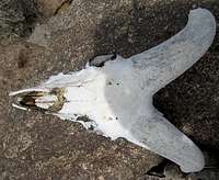 Bighorn Skull Bighorn Skull | 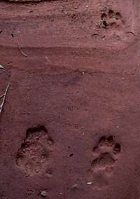 Bobcat Tracks Bobcat Tracks |
Bighorn sheep are abundant, but you may see only their scat, prints, and skeletons.
The beautiful flowers surprise many. This has been a very dry year, yet there were abundant poppies, sunflowers, indigo bush, phacelias and more.
 Prince’s Plume Prince’s Plume |  Purplemat Purplemat |  Phacelia Phacelia |
 Poppies Poppies |  Beavertail Beavertail |  Strawberry Hedgehog Strawberry Hedgehog |
 Indigobush Indigobush |  Mojave Aster Mojave Aster |
Getting There
In Las Vegas, take the i-15 exit onto Lake Mead Boulevard. From the exit, travel east, over the pass between Frenchman and Sunrise mountains, to the fee booth for Lake Mead NRA. From the fee booth, travel a short distance SE to a “T” (this T is about 17 miles east of the i-15 exit onto Lake Mead Blvd). Set your odometer to zero at the T. Turn left and travel NE and E on Northshore road for 14.7 to 15 miles, till a broad wash appears at the right (S). Park on the left (N) side of the road in a paved pullout just beyond the wash; the coordinates of this point are 36.21081, -114.65656 (WGS84). This is the unsigned access for “Cottonwood Springs”. Cross the road to a use trail, and follow the trail S into the wash.The Hike
Cottonwood Spring Access 100k Topo Map 100k Topo Map |  24k Topo Map 24k Topo Map |
The trek consists of three parts: 1) a gentle rise through a rather snaky wash, to a height-of-land at 2.5 miles; 2) a gentle descent of 5.5 to 6 miles, over a normally hard-packed wash; and 3) a rough 1.5 to 2 mile class 2-3 climb over an irregular, often serrated ridge. If you are in decent shape, and the soil is not too moist, you can walk fast for step (1), and jog for most of step (2), at least on the way in. For my 80+F April trip, I cached water at 3.5 and 7 miles. I believe one could ride a mountain bike for most of (1) and (2). Certainly horses travel at least 2 miles up the canyon. (Note: Tracy confirms that he has taken a mountain bike through much of this area.)
For part (1), follow the use trail ESE and SE through the wash, eventually climbing a small dryfall after a cottonwood tree. The route travels roughly SE for a bit more than 2 miles, then abruptly turns ENE for ~0.25 miles to a height-of-land, then turns right nearly 150 degrees, and heads SW on an old, barely visible 4WD road, and shortly turns SE once more. (Caution: I can't overemphasize how tricky navigation can be through the washes in the 1.3 to 2.5 mile leg. Many washes cut off to the side, and all look about the same. Study the maps, take compass bearings, and preferably, load a track into a GPS. This is a bad place to get lost.)
 Cottonwood and Dryfall Cottonwood and Dryfall |  Road at 1.5 Miles Road at 1.5 Miles |  Wash near 2.5 Miles Wash near 2.5 Miles |
Thence begins part (2). You will descend through gentle canyons, and at ~3.5 miles, will hit the dominant flat, gently down-sloping wash. You will follow this wash ENE, then broadly curve SE, for the next 4.5 miles. If the weather has been normal, the wash is hard packed, and makes a good fast-walking or running surface.
 The Flat Wash The Flat Wash |
If there have been recent rains, these washes can be mucky, sticky and slippery in places.
At ~7 miles from the start of the hike, the Guardian ridge will rise rather abruptly on the right side of the wash (an earlier ridge to the right leads to Boulder Peak).
 Ridge Rises from Wash Ridge Rises from Wash |
Now for part (3). At ~ 8 miles, mount the dominant ridge and follow your nose. From here, try to keep to the ridgeline, where there is the most coherent plutonic rock. I’m convinced that no part of this hike need be more than class 2, but you may wish to climb class 3 sections just to get off talus. However, if you find yourself heading up really steep class 4 cliffs, back down and try again; there are no real cliff bands, and there is always an easier way.
 Cliffs Bounds Ridge Cliffs Bounds Ridge |  View From Ridgeline View From Ridgeline |
Once you hit the ridgeline, you still have ~1 mile of up-and-down clambering over igneous rocks, then the stratified sediments of the Thumb Formation. The last 100 yards involve some tricky clambering, but if you are willing to downclimb, nothing need be worse than class 2.
 Summit in View to S Summit in View to S |  Summit Cairn Summit Cairn | > Tribute to BigBendBetty Tribute to BigBendBetty |
You may be tempted to descend off the west side of the ridge, perhaps to climb Boulder Peak. If you do so, be aware that there are lots of very steep talus slopes that end in 50-100’ blind cliffs. Similarly, the route to the east off the top looks easy, but word from Desert Danny (via Nick N) is that the going gets sketchy near the lakeside cliffs. UPDATE: Anya reports there is a way to get down -- cautiously -- on the east side of the peak.
Alternative Access
Feelin’ lucky, punk? Then you may want to go over Pinto Ridge to save a few miles. The cost is an additional elevation gain of about 1000’, and a slow class 3 climb down the south side of the ridge. I learned of this route from Nick N, and have taken it to travel to Sentinel Peak near Sandstone Spring.
The parking spot for this access (36.22800, -114.58688 relative to WGS84) is an additional 4.4 miles east from the “normal” parking spot for the Cottonwood Spring route. From there, one hikes SE for 0.6 miles to the next drainage, then WSW over a low in the Pinto Ridge. Then there is a 1000’ descent down a very steep gully; when you come to an impossible-looking chockstone, you can either descend it directly (short class 4), or head left (east) around it.
 Guardian from Pinto Ridge Guardian from Pinto Ridge |  Nasty Chockstone Nasty Chockstone |
At the bottom of the gully, cut almost directly south for about 0.8 miles to the wash. (Disclaimer: I haven’t done the very last 0.5 mile segment, since I was going to Sentinel, but it is clearly the easiest part of the route. Nick N assures me this last cut-over works just fine.)
UPDATE: The Pinto Ridge cross-over, and yet another alternative route, are shown here in a detailed 24k map.
Red Tape
Access to Lake Mead NRA requires either a temporary, 5-day pass ($5 paid at the fee booth) or a yearly Lake Mead pass ($20), or an "Interagency" pass.Camping
You can camp off the road , away from developed areas. However, I would do this as a day hike. You could camp en route, but you would have to carry all water; there are no reliable springs or streams. The lake is often bounded by high cliffs.Cautions and Logistics
Obviously, this peak is best climbed in cooler weather. The trick then is to get enough daylight hours for a 20-mile trek, 4 miles of which are quite rough. In December, your water needs may be much less; but you have perhaps 9 hours of daylight. No problem, if you are fit enough and plan for a gibbous waxing moon; the first few, and the last few miles are fairly gentle, and could probably be navigated by headlamp (so long as you aware of the one dryfall near the road). April and October provide more daylight, but temperatures may rise above 80F – there is no shade, and the desert sun is merciless.I did this RT hike in 7 hr 40 min. Plan on more time than that.