
|
|
Mountain/Rock |
|---|---|
|
|
46.42058°N / 13.47645°E |
|
|
Hiking, Mountaineering, Ice Climbing, Big Wall, Mixed, Scrambling, Via Ferrata, Skiing |
|
|
Spring, Summer, Fall, Winter |
|
|
8392 ft / 2558 m |
|
|
Overview
Modeon del Buinz / Spik nad Spranjo, 2558m is the mountain in the ridge that comes from Iof di Montasio / Montaz, 2754m from the NW side over some other mounatins, also Spik nad Nosom / Foronon del Buinz, 2531m and continues from the summit of Spik nad Spranjo in the E direction to Punta Plagnis / Spice v Planji, 2411m. and then falls down over the east face to the notch Skrbina Prednje Spranje / Lavinal dell'Orso, 2138m. Here starts to the NE side Vis group.The summit is high and it is nicely seen from all the valleys that surrounds them. On the west side from the meadow Pecol, 1502m and on the south side from the Sella Nevea (Nevejsko sedlo) pass, 1142 m. We have very nice view on it from the Kanin group on the south. From te north side, from the valley Valbruna (Zajzera) we can enjoy the view on his 800 meters high north face. This face united with the north face of Spik nad Nosom / Foronon del Buinz form the big wall at the end of the valley Zajzera.
 The north faces of Modeon del Buinz / Spik nad Spranjo, 2558m, Spik nad Nosom / Foronon del Buinz, 2531m, Spik Hude Police / Cima di Terrarossa, 2420m. (from the left) Seen from the summit of Vis, 2666m.
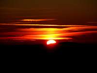 The beautiful sunrise above Julian Alps.
Over its ridges (the west and east)goes the famous ferrata Ceria Merlone which is in the nice weather a beautiful airy and outlookable route. But this is not easy route. It is hard ferrata which is not for everybody. It goes over the airy shelves and defeats some airy faces with help of iron cables. From the start to the end of ferrata you will need around 3-4 hours. This time is only for the ferrata. Here you must to add up the approach to the start and then descent from the end. On this trip we will see many ruins from the First World War. The ferrata does not come directly to the summit but you must approach to the summit over the easiest passages directly from the ferrata. It is not hard, some easy climbing.
Many climbers cross this mountain when they climb the ferrata Ceria Merlone but it is also nice goal if you climb only on its summit. Specially in the ski season there are many nice ravines, couloirs to ski. The most popular and easy ski route goes on the east side of the Spik nad Spranjo through the small valley to the notch in the east ridge of Spik nad Spranjo called Forca de la Val, 2352m.
The view from the top is breathtaking. The mighty west face of Vis / Jof Fuart, 2666m, the long ridge to the Montaz / Iof di Montasio, 2754m and the whole Julian Alps. You can also see many giants of Hohe Tauern group on the north side.
Getting There
The approach valley to the Western Julian Alps will probably be the highway through Val Canale (Udine - Tarvisio). But of course it doesn't reach the heart of this mountain group.
The map of the area.
1. For the south ascent you must deter from the highway in Chiusaforte and travel through Rakolana (Reklanica, Raccolana) valley to Sella Nevea (Nevejsko sedlo) pass, 1142 m. This pass can also be reached from Tarvisio towards south through Valle Rio di Lago (Jezerska dolina). On Sella Nevea you turn towards north-west and drive by a narrow alpine road to Malga Pecol, 1520 m.
2. For the north ascent you deter from the highway some seven kilometers west of Tarvisio and drive south into the Valbruna (Zajzera) valley. The road ends on an alpine meadow on the altitude of 1000 m.
Tarvisio and Valle Rio di Lago (Jezerska dolina) can also be reached from east, from Slovenia (from the Sava valley or over the Predel (Predil) pass and of course also from north, from Austria (from Villach).
For some tourist information see the Tarvisio tourist page.
Maps:
- Tobacco Map 019 - 1:25000 - Alpi Giulie Occidentali Tarvisiano.
- Julijske Alpe - Zahodni del (Western part). Planinska zveza Slovenije. 1:50000.
Route Overview
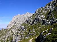 View back to Montaz, 2754m from the ferrata Ceria Merlone.
 Marked routes:
1. From Rif. Brazza (hut) over the west ridge. This route is marked and goes over the first part of the famous ferrata Ceria Merlone over the summit of Spik nad Nosom / Foronon del Buinz, 2531m. Description.
2. From the valley Zajzera / Saisera over Forcella Lavinal dell Orso / Skrbina sprednje Spranje (notch), 2138m. This the route that starts from the north and goes over marked route to the notch and then over the east part of ferrata Ceria Merlone to the top.
3. From the valley Valle Rio di Lago (Jezerska dolina) over Forcella Lavinal dell Orso / Skrbina sprednje Spranje (notch), 2138m. This route goes from the south side to the notch and then also over the east part of ferrata Ceria Merlone to the summit.
4. Ferrata Ceria Merlone. This ferrata starts from the south slopes of Spik Hude Police / Cima di Terrarossa, 2420m and then cross the whole ridge of Spik nad Nosom / Foronon del Buinz, 2531m and Spik nad Spranjo / Modeon del Buinz, 2558m to the notch Forcella Lavinal dell Orso / Skrbina sprednje Spranje, 2138m. Amazing ferrata that goes over airy ridge and shelves.
 Skiing trip to the notch Forca de la Val is very popular. Ski routes:
1. Easy ski route to the notch Forca de la Val, 2352m. From the pass Sella Nevea over the meadow Krnski dol / Cregnedul di sopra, 1500m and then through the big valley directly above the meadow to the notch in the east ridge of Spik nad Spranjo. Very popular ski route. Description.
2. The south ridge of Spik nad Spranjo over the notch Forca Riomoz, 2159m. Harder ski route then the first one. From the meadow Krnski dol / Cregnedul di sopra in the direction to the notch Forca de la Val but soon through the wide SE ravine to the notch Forca Riomoz and then to the pass Buinz (2480 m) and on the summit. I suggest the skiing from the pass. From 40°-45° gradient.
3. The east face of Spik nad Spranjo. Harder ski route over east face of Spik nad Spranjo. 100 meters below the notch Forca de la Val you turn to the left and over the best passages to the summit of Spik nad Spranjo. Ski estimation 300 m, IV-, passages to 45°. Some photos.
Red Tape
 An edelweiss.
No limitations or special permits.
When To Climb
The best and the easiest time is in the snowless season. That is in Summer and Autumn. But also in Winter there are some nice routes for climbing. But be careful because of avalanches and the loneliness of north face. In snow season there is very popular to ski down the valley from the notch Forca de la Val, 2352m just from the east ridge.Camping
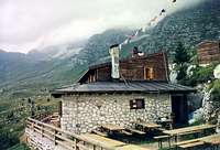 Rif. Brazza (hut), 1680m.
Some huts and bivouacs.
On south:
- Rif. Brazza, 1660 m (parking place just below it).
On east side:
- Refiugio Guido Corsi (hut), 1874m
On north:
- Rif. Attillio Grego (parking place 400 m below it in Valbruna or on Sella di Somdogna, 1398m, 15 minutes away), 1395 m.
- Bivacco D. Mazzeni (bivouac), 1630m, below the north face.
Then a lot of camping places you can find in the valleys around Vis and Montaz group.