
|
|
Mountain/Rock |
|---|---|
|
|
26.48056°S / 66.05856°W |
|
|
Hiking |
|
|
Spring, Summer, Fall, Winter |
|
|
7546 ft / 2300 m |
|
|
Overview

The Cerro Alto del Rey (High Mountain of the King in English) is located in the Tucuman province, in North West Argentina. The summit itself is hardly known, but on its slopes there are the Ruins of the Quilmes civilization.
This mountain actually provides several trails, around and through the ruins. A good way to hike and discover another culture !
Historical Background :
It is thought that the Quilmes civilization settled down there around year 1000. Their settlement was at the time about 30ha large and contained 5000 people.
In 1480 the Incas tried to invade the Quilmes fortress (located on the slopes), but failed to win. When the Spaniards arrived in 1667, they manage to defeat them and deported the 2000 people remaining to Buenos Aires. Nowadays the Quilmes is still remembered in Argentina as a strong civilization, and the main beer brand even took its name from it : Quilmes ! Only the base of the ancient walls are now intact.
Getting There & Staying...

The closest main town around is Cafayate (Salta Province). Drive south bound on road RN40 for about 25 kms. When arriving close the archeological site, it will be indicated.
It is not possible to camp anywhere around the ruins.
The best bet would be to sleep in Cafayate. A nice and rather cheap place there is : Hostal El Portal de Viñas (8$ per person and per night).
Friendly and helpful lady-owner.
Hiking on Cerro Alto del Rey
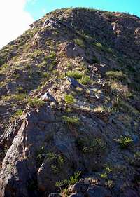
To enter the area you will have to pay 2 pesos (0,70$ per person). Then you are free to walk on any trail, apart from the top one going to the mountain summit, where they expect you to take a guide, as it is protected area.
The ruins of Quilmes are on the South East slope of Cerro Alto del Rey (better light in the morning).
Green Trail : easy
1,77 kms / Between 1858m and 1915m
Yellow trail : easy
1,94 kms / Between 1858m and 1965m
Red Trail : moderate
2,80 kms / Between 1858m and 2060m
Grey Trail : moderate
3,5 kms / Between 1858m and 2300m
A guide is required for this trail.

Books, Maps & Weather

A map is available at the entrance of the Archeoligical site.
A good guibebook would be : Argentina (Lonely Planet)
And for weather forectast : Infoclima > Cafayate