
|
|
Mountain/Rock |
|---|---|
|
|
42.38838°N / 120.23446°W |
|
|
Lake |
|
|
Hiking |
|
|
7548 ft / 2301 m |
|
|
Overview
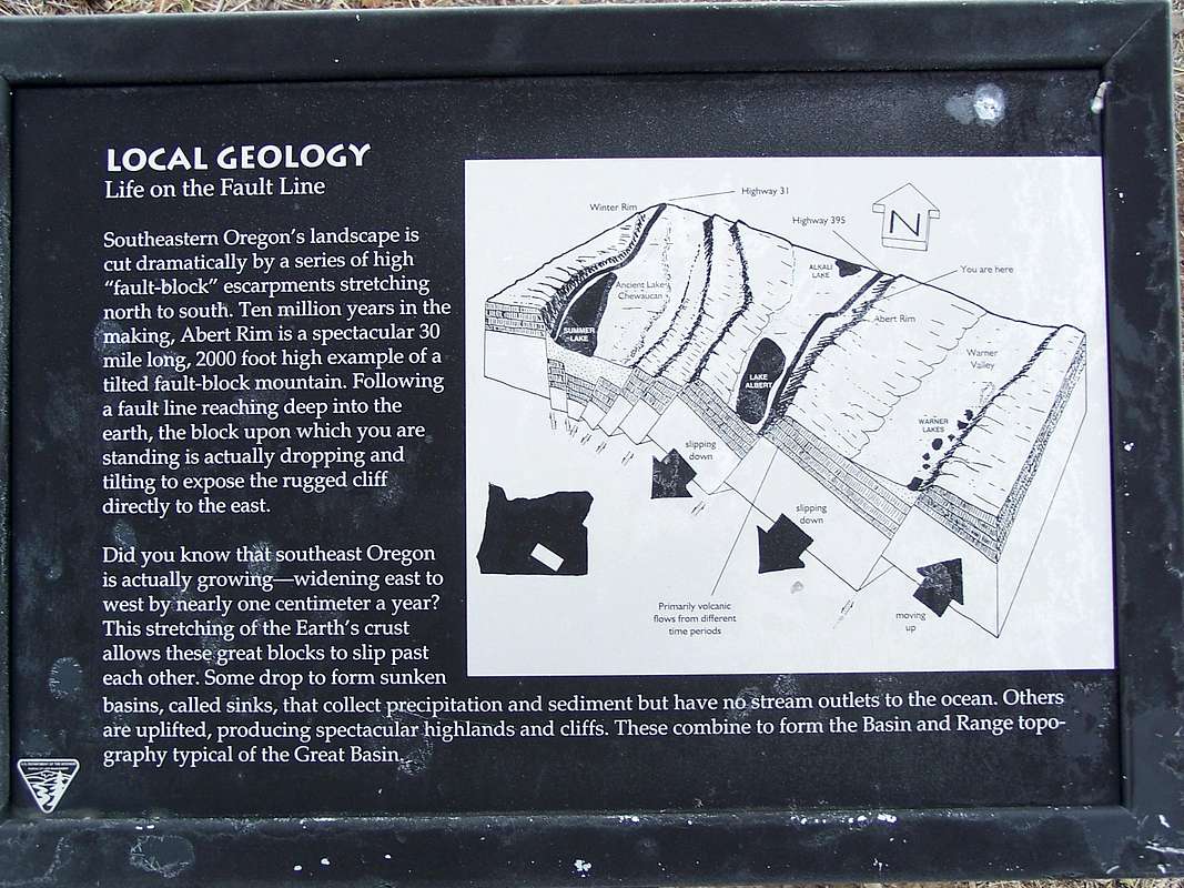
Abert Rim is a massive basalt capped wall rising above Lake Abert in Central Southern Oregon. Stretching over 30 miles from the east shore of Alkali Lake in the north to nearly Lakeview in the south; this distinctive rim is a classic Basin and Range fault block much like Hart and Steens Mountains. As such, Abert Rim is considered the longest exposed fault escarpment in the United States. Much of the rim is protected by soaring cliffs and extremely steep boulder fields. Reaching the summit plateau can be done by scrambling up narrow ravines on the west face, or circuitous 4x4 roads that make there way up the gentle east slopes. The absolute highpoint of Abert Rim was the location of a Fire Lookout until it was tore down in 1976. A picture of the lookout before it was destroyed can be found HERE . Perhaps the best viewpoint from Abert Rim can be reached in the directions listed in the Getting There section.Although difficult to find, petroglyphs can be found on boulders along the lakes shore near the Abert Rim geological marker sign. Also in this area, it is possible to see Bighorn Sheep on the rim above. Below much of the rim lays Lake Abert, the third largest saline lake in the United States, and the third largest lake in Oregon. Typically covering 60 square miles, Lake Abert is exceedingly shallow and nearly dries up during extreme dry spells.

A wide variety of migratory birds such as snowy plover can be seen at Lake Abert where they gather each fall to feed on brine shrimp. Higher on the rim predatory birds such as Peregrine Falcons and Ferriginous Hawks may be seen. Most importantly Rattlesnakes are very common in this area, be very cautious navigating your way up and around Abert Rim.
Getting There - Juniper Creek Route
Although the GPS coordinates listed at the top of the screen are for the absolute highpoint of Abert Rim which can be driven to, these directions are for the more scenic Juniper Creek Viewpoint; a scramble up the side of the rim from Lake Abert. To reach Juniper Creek from Lakeview travel 22.5 miles north to Valley Falls, which is a junction with Highway 31. At Valley Falls continue 6 miles north on US395 to a wildlife viewing area on the edge of Lake Abert. Here you will find a large turnout to park in on the west side of the highway. Cross the road and climb the embankment where you will find a dirt 4x4 path that leads up the side of the rim a short distance. Following this messy 4x4 road will start you up Juniper Creek, once the road quickly ends, follow the line of aspens to a notch in the cliffs above where you can easily gain access to the rims top. Once on top, Warner Peak can be seen to the east and surprisingly an alpine forest (Colvin Timbers) can be seen the southeast. A look to the west reveals many other fault block ranges, most prominently Winter Rim above Summer Lake. This route runs 3 miles roundtrip with 2000 feet of elevation gain. The GPS coordinates for this viewpoint are Lat: 42.53407 Long: -120.20856. BEST TIME TO HIKE - NOVEMBER TO APRIL.
Red Tape
Some areas of Abert Rim are privately owned and protected by barbed-wire fence, so obviously obey posted no-tresspassing laws. With that stated, much of Abert Rim behind Lake Abert including Juniper Creek Canyon are not fenced off and can be hiked freely. Once on top of the rim, there were no fenced areas that I could find. The majority of Abert Rim is BLM property.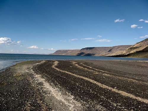 Lakeside of Lake Abert
Camping
There are no developed campgrounds at Lake Abert, check the Fremont National Forest Website for nearby campgrounds.Weather

External Links
Tague's Butte Hang Glider Launch site on Abert Rim