
|
|
Mountain/Rock |
|---|---|
|
|
34.68720°N / 80.20820°E |
|
|
Mountaineering |
|
|
19524 ft / 5951 m |
|
|
Overview
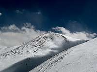
 Satsum Kang from high on Sirengou I
The climb of Satsum Kang will never win the price as the most exciting mountaineering experience, but the views from the summit are astonishing. If I could rate both in the normal Summitpost manner I'll give the climb three stars and the views eight.
Everything is very relative, but of the peaks in the outback of Xinjiang and Xizang/Tibet it's one of the most accessible. Located right at the Xinjiang Highway (Kashi - Shiquanhe/Ali) you can basically hop off your vehicle and start walking towards the summit. In the warm season the climb can be done in sturdy boots, windproof clothing and with only basic mountaineering experience. Needless to say, you have to be well acclimatized as the peak is over 300m higher than Europe's highest peak (Elbrus) and just 250m lower than North America's number one (Denali). Also, if the mountain is covered by snow, bring crampons. It can be icy on the summit slopes.
If travelling through the area and you want to a fantastic view from above, Satsum Kang is one of best alternatives. From the summit you can see the strange looking peaks in the Sirengou group, the turquoise Sirengou lake, Xinjiang Highway from above and loads of other mountains further away.
I don't know when the peak was first summited or by whom, but an educated guess is it was first climbed by soldiers in the PLA (People's Liberation Army), which during a period climbed a lot of mountains in the area. The reason I think that's the case is the size of the summit cairn, which is huge and even for a medium sized mountaineering party it would've taken half a day to pile up that amount of rocks at that altitude.
I don't know anything about the origin of the name of the peak, but the pass close by is called Satsum La and when I asked for the name of the peak I was told it was Satsum Kang. It's the Tibetan name of the peak, there may be a Chinese as well.
Getting there and a warning
 High on the peak
Whichever way you choose, it's a very long journey to get there.
From Xinjiang - Kashi/Kashgar
Kashgar is an oasis town on the brink of The Taklamakan Desert. It has always been a transport hub and it's the last place where you can find flights and railway transport to.
From here there are basically two alternatives:
1. With a group in a rented (it comes with a driver in China, as foreigners aren't allowed to drive on their own) vehicle, usually a Landcruiser. Travel agents in Kashgar can arrange travel permits, a vehicle, a guide and everything else you may want or need.
2. Using local transport or hitching.
Take a bus to Yecheng/Kargalik. It's about 4 hours on good road and the cost is about $5-6.
Get a local bus to the little junction settlement of Aba. About 10-15min/$0.6-0.8
The bus station for transport towards Satsum Kang is located about 1km from the turnoff from the main road, on the left hand side of the main road leading towards your destination. The bus you have to take is heading for Ali/Shiquanhe, which is (at least!) a 30h ride from Aba. Ask for a ticket to Sirengou. It should be about $70-80. Count on at least a 24h journey. Sirengou is a small settlement at a lake. It consists of about ten ramshackle "buildings". You can eat simple meals, stay the night in extremely basic dorms ($1.2-2) and buy soft drinks, bisquits and noodles. Don't expect much of this place.
Hitching can be a bit tricky and the situation changes all the time. Sometimes foreigners are allowed to hitch, at others the truck drivers are told by the police they can't pick up hitchers. If you're lucky you can get rides for free, but most of the time you have to expect as much as the bus ticket costs. Bargain hard and ask different truck drivers before accepting a ride.
From Xizang/Tibet - Ali/Shiquanhe
First, getting to Ali is a long way from everything, about 1300km from Lhatse in central Tibet and about 1750km from Lhasa. Most travellers arrive in Ali by pre-arranged Landcruiser or by bus from Lhasa or Lhatse.
From ALi the alternatives are the same as from Xinjiang province. Arrange a Landcruiser, go by bus or hitch. Hitching is much easier from this direction to Sirengou than from the other side as there are no checkpoints and the truck drivers pick up hitchers much more often. The bus is about $20-25/7-10h.
 Summit view and lake
Altitude warning!
If you arrive from Ali, you can skip this section.
Leaving from the lowlands of Xinjiang at roughly 1500m above sea level, straight up to the high passes over the Kunlun can be extremely dangerous. First you cross two passes at about 5000m, then you drop a bit, but after that you're firmly on altitudes over 5000m. For an unacclimatized person this can be fatal. Best option is to get some acclimatization before departing from Kashgar. One good way is to spend some time trekking in the beautiful area around Muztagh Ata, which is located some hours away from Kashgar. Take this warning seriously!
Travelers have had to turn back to the lowlands, badly suffering from AMS and worse - some have even died on the journey towards Ali.
Red tape
 Late evening light on Sirengou, seen from Satsum Kangri
A valid visa for China is easy to get from any Chinese embassy. The exception is the one in Bishkek, Kyrgyzstan, where you need a letter of recommendation and it’ll take up to 10 days to process the application. Better get it elsewhere. If you plan to stay for a long time in China, Hong Kong is by far the best place for visas, where you can pick up a 6 month visa in 3-4hours. One place amongst hundreds of others is Cosmic Guest House, Mirador Mansions, Nathan Road. For US citizens the Hong Kong option doesn't work.
Officially you need a permit to climb Satsum Kang. It’s 30$.
The peak is not a famous one, it's below 6000m and therefore no one really cares of you climb it.
Chinese embassies.
Camping & accommodation
 Summit, cairn and my Jolly Roger
Camping.
You can camp everywhere in the area. Officially it's forbidden to camp in China, but no one cares. I have had many visits at my camp spots by both the police and the military and they have only been friendly and curious.
Accommodation.
The only place close to Satsum Kang is Sirengou, a little truck stop with about ten shacks. A bed in a very basic dorm starts at ($1.2-2). It's a roof over your head, a bed and in some places a thermos of hot water included in the price. These places also have a restaurant part where you can eat cheap by western standards, but horrendously expensive by Chinese. Expect to pay about Y15-25/dish, which at the time writing is about $2-3.5.
Sirengou is about 5km from the foot of Satsum Kang.
When to climb
 View south
The area is of a very high altitude. All the surrounding areas are over 5000m and the Aksai Chin area is infamous for being a cold place. It's a place where a sudden blizzard can hit any time of the year and winter temperatures can drop below -40C. Therefore it's a good idea to attempt the peak in the warmest possible season. June to August is the summer months in the area. The nights can be very chilly even then and expect minus degrees on the summit. The unfiltered sun of high altitude can on the other hand almost fry you on a hot day. Be prepared for temperature amplitudes of at least 40 degrees even in the summer months.
Mountain conditions
 View north
Satsum Kang is an easy scramble. Some parts are up to 40 degrees on gravel and rock and about the same steepness on snow higher up. During periods when snow is melting it can be icy, so if uncertain bring your crampons. It's a dry area, but if it snows here it's usually coming as a blizzard. Really fierce winds are common. It's an easy peak, but be careful. The weather can change very quickly and when it changes it doesn't get bad, it gets really miserable.
Preparations
 Seen from south (from high on Meng Qin Feng)
Money
Before leaving any of the larger cities get as much cash in Renminbi/Chinese Yuan as you think you'll need. There are very few places in Xizang/Tibet and in the outback of Xinjiang which changes money and it's very far in between the ATMs.
Provisions
Buy anything you need before leaving the main cities. There are plenty of great supermarkets as well as smaller corner shops in China. You can find anything you can possibly need there. When you're on the Xinjiang Highway you're usually down to the choice of noodles, bisquits, soft drinks, powdered milk and candy.
Books & maps
BooksThere's no mountain literature about the area. If you need a guidebook for general knowledge about traveling in the area, Trailblazer's Tibet Overland is one of the better. Forget about oh so famous Lonely Planet for this area. It's crap.

You'll see quite a lot of wildlife along the way, especially if you're hitching, and then it can be interesting to know what you see. A good book about the larger mammals in the area is George Schaller's Wildlife of the Tibetan steppe.

Maps
No mountaineering map of the area exists. The closest to a detailed map you'll get is either the Russian or American air force charts.
Maptown sells the American ONC and TPC. The Russian equivalents are more detailed and have more contour lines, but are harder to find. Omnimap has them all, but it's hard to buy separate sheets and I doubt you want to buy a set of 1643 sheets for $13072 :-). Please let me know if separate sheets are available somewhere on the www.
The overview maps of Tibet/Xizang and Xinjiang are usually horrible and full of errors. Some of the better is published by Gizi and Gecko, but be aware of that for example Sirengou isn't on it. Ok for planning, but not more. Gizi Xinjiang and Gecko Xizang/Tibet
Links
 First sight